Trusted Utah Land Surveyors
When property lines, building plans, or lender requirements are on the line, finding a dependable residential land surveyor in matters. This guide breaks down what a residential land survey does, why homeowners in Utah County need one, which survey types fit common situations, how licensed surveyors work in the field, and what to expect for cost and timing. You’ll get practical steps to request an accurate quote, a checklist of documents to gather, and a clear look at how surveys prevent disputes or encroachments during construction. We also describe the modern tools (GNSS, total stations, UAVs, CAD) that speed work and improve precision, and we outline typical use cases—home purchases, fence installs, and manufactured home placements. Read on for city-specific guidance for Provo, Orem, and other Utah County communities, plus straightforward next steps to .
What Is a Residential Land Survey and Why It Matters in Utah County
A residential land survey is a professional measurement and mapping service that establishes your property corners, creates or confirms the legal description, and produces a recorded plat or certificate useful for closings, permits, and disputes. Surveyors combine historical records research with on-site measurements of monuments and control points, then draft a certified document that shows boundaries, easements, and improvements. The biggest benefit is legal clarity: a survey gives homeowners a defensible map of where their property begins and ends, reducing risk during real estate transactions, construction, or refinancing. In Utah County, varying terrain, local setback rules, and municipal permit requirements make an accurate land survey especially important to avoid costly mistakes during development.
— and how a boundary survey protects your rights and when a property line survey is necessary for a Utah County home.
Residential boundary surveys protect property rights by creating certified evidence of corner locations and legal descriptions. When monuments are found or set and a plat is produced, those records serve title companies, lenders, and courts and reduce ownership ambiguity. For example, a homeowner planning a fence can rely on the survey to avoid encroaching on a neighbor’s easement or to settle a long-running boundary disagreement without escalation. Keep your survey plat safe and mark corners physically before construction so contractors and neighbors can act on the information the survey provides. For information on costs, should be considered.
When to Schedule a Property Line Survey for Your Utah County Home
Homeowners typically need a property line survey when buying or selling, applying for building permits, installing fences or decks, placing or replacing a manufactured home, or resolving a boundary dispute. The need becomes urgent when a permit application requires an accurate plat or a title company asks for documented boundary evidence to close. If you’re planning improvements near a lot line or your deed references are unclear, get a survey before construction to prevent rework or fines. Gathering deeds, existing plats, and any prior survey reports before you contact a surveyor speeds quoting and helps them scope fieldwork correctly.
Frequent triggers for a in Utah County include:
- Real estate closings — a survey clarifies exactly what’s being transferred.
- Permit submissions — municipalities often require accurate plats to verify setbacks.
- Home improvements — fences, decks, and garages should be sited using verified lines before foundation work.
Addressing these needs early keeps projects moving and reduces the chance of conflict with neighbors or local authorities.
How Much Does a Residential Land Survey Cost in Utah County?
Survey cost in Utah County varies with several factors: the lot size, terrain and vegetation, the complexity of record research, whether original corner monuments are found or must be reset, and the required deliverables (paper plat, sealed digital files, legal description). Small, easy-access lots with clear monuments are generally less expensive than large rural parcels with steep slopes or heavy brush that require extra field time. Specialized requests—topographic detail, lender certifications, or tight turnaround—also change price and schedule. To get a precise estimate, a surveyor will need site access, the legal description or deeds if you have them, and the purpose of the survey so they can define scope and deliverables.
Use the comparison below to see how time, complexity, and typical cost drivers differ across common residential survey types.
What Influences the Price of a Residential Boundary Survey?
Key price drivers include acreage, terrain difficulty (steep slopes, rock outcrops), vegetation that slows fieldwork, the clarity and availability of title and plat records, and whether monuments are recovered or must be set. Deliverables such as a sealed paper plat, CAD/GIS files, or a formal legal description add time and cost. Urban lots with clear record chains and easy access usually require less field and research time than rural or irregular parcels where additional investigation and monument recovery are needed. Understanding these factors helps you give surveyors the right information when asking for a quote and reduces scope surprises.
Next, practical guidance on preparing to request an accurate quote from a licensed surveyor. are an important part of the process.
How to Get an Accurate Quote from Licensed Surveyors in Utah County
To get a reliable quote, provide the surveyor with the property address or legal description, the survey purpose (sale, fence, permit, FHA inspection), any deeds or plats you have, and notes about site access (gates, animals, long driveways). Ask for a written scope that lists deliverables, timeline, assumptions (for example, that monuments may not be found), and any potential extra charges. If the site is remote, be ready to schedule a quick site visit or share photos so the surveyor can refine labor estimates. Compare written quotes from multiple licensed surveyors and confirm who will file plats with the county recorder if required.
For a tailored estimate, reviews property details and intended use to provide clear, written proposals. Asking for a written scope and timeline keeps everyone aligned before fieldwork begins.
What Types of Residential Land Surveys Are Common in Utah County?
Common residential surveys in Utah County include boundary surveys, property line surveys, FHA foundation inspections for manufactured homes, topographic surveys for grading and drainage, and plat or lot surveys used in subdivisions. Each serves a specific purpose: boundary surveys define ownership lines; topographic surveys map elevations and features; FHA inspections certify foundation conditions for lender compliance. Selecting the right survey at the start saves money and speeds permitting.
The table below pairs survey services with typical deliverables and common use cases.
Boundary Survey vs. Property Line Survey — What’s the Difference?
A boundary survey usually includes full records research, recovery or setting of corner monuments, precise field measurements tied to control, a sealed plat with bearings and distances, and a certified legal description. A property line survey is typically narrower: it locates and marks the practical line between properties for construction or dispute avoidance without the deeper record analysis or formal platting. Boundary surveys carry more legal weight for title, platting, and recording; property line surveys are useful for everyday decisions like where to place a fence. Choose based on whether you need a recorded, certified boundary survey or simply an on-site finding of the lines.
Understanding this difference helps you request the exact deliverable municipal staff, lenders, or title companies require.
How FHA Foundation Inspections Support Manufactured Home Financing
FHA foundation inspections document foundation adequacy, anchoring, dimensions, and other site-specific items lenders require to finance a manufactured home. Inspectors verify checklist items and provide a certification lenders use to approve financing and demonstrate compliance with Federal Housing Administration standards. For homeowners, an FHA inspection helps speed loan approvals and ensures lenders have the documentation they need for manufactured home placements or refinances. These inspection reports are separate from boundary or topo surveys but often accompany site planning and title requirements for installations.
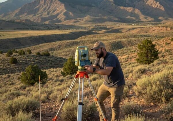
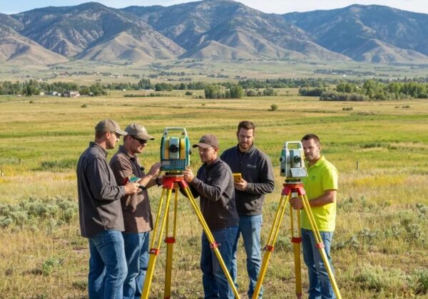
How Licensed Residential Land Surveyors in Utah County Conduct Surveys
Licensed residential land surveyors follow a phased process: initial consultation, records research, establishing field control, data collection, monument recovery or setting, drafting, client review, and final certification and delivery. This sequence ties measurements to recognized control, respects historical evidence, and produces certified plats or legal descriptions suited to the survey’s purpose. Field crews use instruments and workflows that increase accuracy and reduce time on site, while in-office drafting and quality control ensure documents meet county recording standards. Knowing these phases helps homeowners anticipate scheduling, access needs, and review steps.
Below is a concise table linking common survey tools and steps to their purpose and homeowner benefit.
Technology choices affect cost and scope — understanding tool benefits helps you balance budget and required precision.
At Ludlow Engineering, we combine field control, GNSS, and UAV methods as appropriate and pair those with in-house drafting and engineering review to produce reliable, record-ready plats and inspection certifications. Keeping surveying and engineering under one roof streamlines communication and gives homeowners a single point of accountability for measurements and deliverables.
Can Residential Land Surveys Resolve Property Line Disputes in Utah County?
Yes. A professional survey produces certified evidence of boundary locations, clarifies easements, and documents encroachments or inconsistencies in historical records. Surveys show whether monuments exist, deliver a legally defensible plat and legal description, and provide a neutral technical basis for negotiations, title work, or legal action. After a survey, homeowners can ask for corrective action, move or rebuild fences, or pursue formal record updates. Pairing accurate survey data with respectful neighbor communication often prevents disputes from escalating to court.
Knowing common causes for disputes helps explain how a survey targets resolution and prevents future issues.
Common Causes of Residential Property Disputes
Typical causes include unclear or outdated deed descriptions, lost or disturbed monuments, fences placed without documentation, and overlapping easement claims. Over time, improvements and natural shifts can create de facto boundaries that don’t match recorded descriptions. A professional survey uncovers original evidence and delivers a current, certified representation to correct misunderstandings. Surveying before construction or a property transfer avoids many conflicts by establishing a clear starting point for everyone.
These examples show why being proactive with a survey beats reacting to a dispute later.
How Survey Results Prevent Fence and Structure Encroachments
Survey results guide correct placement of fences and structures by marking property corners and providing a certified line for contractors and permitting officials to follow. Before construction, request corner marking, use the survey plat for permit submissions, and confirm setback distances to prevent violations. If an encroachment is found, the survey provides the documentation you need to negotiate a fix or pursue legal remedies. Including survey documentation with permit applications also lowers the risk of post-construction enforcement by local authorities.
Following these steps helps ensure new work respects recorded boundaries and minimizes neighbor disputes.
Where to Find Trusted Residential Land Surveyors in Provo, Orem, and Other Utah County Cities
Homeowners in Utah County should look for licensed firms that list residential boundary, topographic, and FHA inspection services and demonstrate experience with county recording and municipal permitting. Choose providers that explain their records research process, field monumentation practices, and certified plat delivery so you know what will be recorded. Ask for a written scope and pick a surveyor familiar with local recorder offices and setback rules. For city-specific needs in Provo, Orem, and nearby communities, prioritize firms that share clear timelines and example deliverables to speed permit reviews.
Understanding the legal framework for land surveying in Utah helps clarify a professional’s responsibilities and standards of practice.
Why Ludlow Engineering Is a Strong Choice for Residential Surveys in Utah County
Ludlow Engineering and Associates LLC has served Central Utah since 1975. We’ve grown into a civil engineering and surveying firm that focuses on development, site plans, small water and sewer projects, and land surveying — while continuing to support smaller rural clients across the region. Our team includes in-house professional engineers and licensed land surveyors, which helps us manage projects from fieldwork through final deliverables.
Our services cover a wide range of surveying and civil engineering needs: boundary and ALTA title surveys, residential and commercial site plans, subdivision design, house plan drafting and engineering, water and sewer plans, well proofs, FHA manufactured home inspections, and flood and water-rights certifications.
Whether you need a precise property line survey or a boundary survey before a commercial build, our civil planning team is ready to help. We’ve supported clients across Utah, including:
- Juab County
- Utah County
- Millard County
- Sanpete County
- Sevier County
- And more
How to Contact Us and Request a Residential Land Survey Quote in Utah County
When you request a quote, provide the property address or legal description, the purpose of the survey (sale, fence, permit, FHA inspection), any recent deeds or plats you have, and your preferred timing. Ask the surveyor for a written proposal that lists scope, deliverables (sealed plat, digital files), assumptions about monument recovery, estimated timeline, and any extra fees for monument setting or additional research. Expect the surveyor to request site access and possibly a short site visit to finalize pricing. After you receive the written quote, confirm who will file the plat with county offices and what the final deliverables will look like.
- Prepare documents: Gather deeds, prior plats, and any known corner evidence.
- Define purpose: Tell the surveyor whether the survey is for closing, permitting, a fence, or an FHA inspection.
- Request a written scope: Ask for deliverables, assumptions, timeline, and a price estimate.
These steps make quoting smoother and ensure the survey you order fits your needs.
Providing this information up front helps surveyors deliver accurate, timely written estimates and keeps your project moving.
This guide outlines the key decisions Utah County homeowners face when seeking residential land surveyors: how surveys protect your interests, which survey type you need, typical cost drivers, and how professional surveys support permitting and prevent disputes. Use the checklists and tables above to prepare your request, pick the right survey, and get a clear written scope so fieldwork and recording proceed without delay.
Frequently Asked Questions
What should I do if my property line survey reveals an encroachment?
Start by reviewing the survey findings with your surveyor so you clearly understand the issue. Then discuss the results with your neighbor and seek a practical resolution—often the fix is moving a fence or adjusting a structure. If you can’t reach an agreement, consult a property attorney. A certified survey plat is strong evidence for negotiations or legal action if needed.
How often should I update my residential land survey?
Update your survey whenever you make significant changes—new construction, major landscaping, or when a boundary dispute arises. Also consider a new survey when buying or selling property to ensure current, reliable boundary information. Keeping your survey current ensures you have accurate data for permits and property decisions.
Can I conduct my own property line survey?
You can visually estimate lines with basic tools, but a professional survey requires specialized equipment, record research, and legal knowledge. Licensed surveyors are trained to interpret historical documents, measure accurately, and deliver legally defensible results. For real estate closings, permits, or formal disputes, hire a licensed surveyor to ensure compliance and accuracy.
What are the legal implications of a boundary survey?
A boundary survey creates a legally recognized depiction of property lines and can be used in court to resolve disputes. It protects your rights during transactions by clearly documenting boundaries for all parties. Keep survey documents accessible, as they may be required later for sales, permits, or legal matters involving your property.
How do I choose the right surveyor for my needs?
Check qualifications, licensing, and local experience. Look for surveyors who specialize in residential work and understand Utah County recorder and municipal requirements. Read reviews, ask for referrals, and request examples of deliverables. A good surveyor will provide a clear scope of work, transparent pricing, and be willing to answer your questions.
What technologies do modern surveyors use?
Modern surveyors use GNSS (GPS) control, total stations, and drones (UAVs) to increase accuracy and efficiency. GNSS provides precise coordinates, total stations measure angles and distances with high precision, and drones capture aerial imagery and topographic context quickly. These tools speed fieldwork and improve data quality for homeowners.
What should I expect during the surveying process?
Expect a few clear phases: initial consultation, records research, field measurements and monument recovery or setting, drafting, client review, and final certified delivery. Your surveyor should keep you updated on timeline, deliverables, and any issues that arise. Understanding the steps helps set realistic expectations for access, scheduling, and final results.