

Land Surveyor Near Me in Utah: Costs, Timelines, and the 9 Questions to Ask Before You Hire
Finding a dependable land surveyor in Utah doesn’t have to be stressful. This guide walks you through typical costs, realistic timelines, and the key questions to ask before you hire. Read on to understand the types of surveys available, what affects price and schedule, and how to pick a surveyor who will deliver accurate results on time. For more information, check out land surveys.
What Are the Typical Property Survey Costs in Utah?

Budgeting for a survey means knowing which factors move the needle. Survey fees in Utah vary by the survey type, site conditions, and the experience of the firm you hire. Below we explain the main cost drivers so you can plan more confidently.
How Is the Cost of a Property Boundary Survey Determined?
The price for a boundary survey depends on several practical considerations, including:
- Survey Complexity: Irregular property lines, dense vegetation, or many corners add time and equipment needs.
- Location Factors: Urban parcels, difficult access, or steep terrain can increase field time and permit requirements.
- Surveyor Experience: Established firms may charge more, but their local knowledge and accuracy reduce risk down the road.
What Is the Average Price Range for Land Survey Services in Utah?
Survey costs in Utah commonly range from $400 to $1,200 depending on the scope. The table below compares typical services and the main factors that affect price.
Use these ranges as a planning guide. For an accurate estimate, a surveyor will consider your parcel’s specific features and the deliverables you need.
How Long Does a Land Survey Take in Utah?
Survey timelines depend on the survey type and site conditions. Field work, office processing, and any permitting or coordination each add time. Below are common factors that influence schedule and typical timeframes for different projects.
What Factors Influence the Land Survey Timeline?
Common factors that can speed up or delay a survey include:
- Weather Conditions: Heavy snow, rain, or extreme heat can slow field crews.
- Survey Complexity: More corners, monuments to locate, or mapping detail require extra hours in the field and office.
- Regulatory Approvals: If your project needs permits or coordination with local agencies, expect additional lead time.
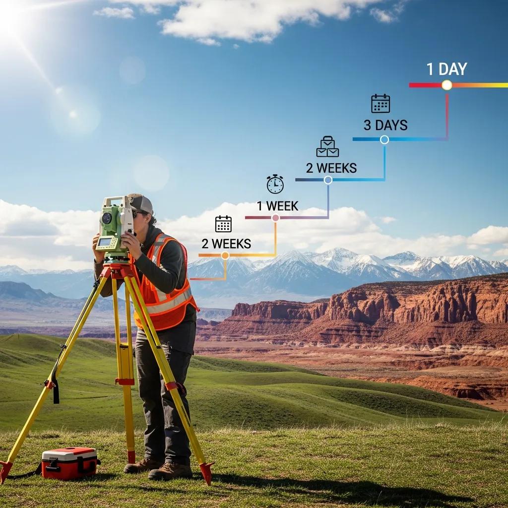
How Does Project Type Affect Survey Duration?
Typical durations by project type:
- Residential Surveys: Often completed in 1–3 days for standard lots, plus a few days of office work.
- Commercial Surveys: Larger sites or more detailed deliverables commonly take 3–7 days in the field and additional office time.
- Specialty Surveys: Environmental, boundary dispute work, or complex topographic studies can take several weeks depending on scope.
What Are the 9 Critical Questions to Ask Before Hiring a Land Surveyor in Utah?
Asking the right questions helps you compare firms and avoid surprises. Before hiring, be sure to ask:
- Are you licensed in Utah?
- How long has your firm been in business?
- Can you share recent client references or project examples?
- Which survey types do you handle most often?
- What timeline do you expect for my project?
- How will you handle unexpected issues or discrepancies?
- What exactly is included in your quoted fee?
- Do you carry professional liability insurance?
- What technology and methods will you use on site?
How to Verify Licensing and Credentials of a Utah Land Surveyor?
Verify credentials by:
- Looking up the surveyor on the Utah Division of Occupational and Professional Licensing website.
- Requesting proof of insurance and any bonding required for the job.
- Checking for memberships in professional groups such as the National Society of Professional Surveyors.
What Should You Know About Surveyor Experience and Local Knowledge?
Local experience matters. A surveyor who knows Utah’s permitting practices, county records, and common boundary issues will work more efficiently. Ask about:
- Past projects in your city or county.
- Familiarity with local zoning and land-use rules.
- Any specialized certifications or training the team holds.
Which Types of Land Surveys Are Commonly Used in Utah?
Different surveys serve different goals. Knowing which type you need will help you get the right deliverable and price. Below are the most common survey types used across Utah.
What Is Included in a Property Boundary Survey?
A typical boundary survey will include:
- Boundary Line Determination: Accurate placement of your property lines based on records and field evidence.
- Survey Markers: Physical monuments or flags placed to mark corners and critical points.
- Legal Descriptions: A written description suitable for deeds or title work, plus a stamped drawing.
Accurate boundary work often requires combining historical records, field evidence, and legal interpretation — a mix of technical and legal considerations that can affect outcomes.
Property Boundary Determination: Legal, Surveying, and Economic Factors
This interdisciplinary paper examines how legal frameworks, surveying practice, and economic factors interact when determining property boundaries. It discusses why parties sometimes turn to courts rather than market solutions to resolve boundary disputes, and it highlights surveying and economic reasons that influence those decisions — from historical map evidence to the transaction costs of enforcing boundary outcomes.
The determination of the “true” property boundary in planned development: a
Coasian analysis, LWC Lai, 2018
How Do Construction Staking and Topographic Mapping Differ?
These services support different project phases:
- Construction Staking: Stakes out building corners, utilities, and other elements from construction plans so crews can place work accurately.
- Topographic Mapping: Produces a contour map and spot elevations to show terrain, drainage, and features needed for engineering and design.
How to Choose the Right Land Surveyor Near Me in Utah?
Pick a surveyor who combines solid references, clear communication, and local experience. Below are practical tips to evaluate candidates efficiently.
What Role Do Client Testimonials and Case Studies Play?
Testimonials and case studies reveal how a firm handles real problems and schedules. Look for:
- Recent, location-specific reviews or project write-ups.
- Examples that show how the firm solved challenges similar to yours.
How Does Timely Service Delivery Impact Project Success?
Delays in surveying ripple through the entire project. Late surveys can raise costs, push back construction, and complicate permitting. Choose a firm that sets realistic timelines and communicates proactively to keep your schedule on track.
Ludlow Engineers and Associates is a Utah-based land surveying and civil engineering firm offering property line surveys, construction staking, and topographic mapping. We focus on precise boundary determination, timely turnarounds, and practical local guidance. If you need reliable surveying services in Utah, we’re available to discuss your project and provide a clear, written estimate.
For more details about our services, visit Ludlow Engineers and Associates.
Frequently Asked Questions
What should I consider when choosing a land surveyor in Utah?
Prioritize licensing, relevant experience, and local knowledge. Confirm insurance and ask for references from similar projects. Clear, upfront communication about timeline, scope, and deliverables will help you avoid surprises.
Are there any specific regulations for land surveying in Utah?
Yes. Surveyors must follow state rules enforced by the Utah Division of Occupational and Professional Licensing. That includes maintaining accurate records, adhering to professional standards, and meeting legal requirements for recorded surveys.
How can I prepare for a land survey on my property?
Gather deeds, prior surveys, and tax records. Clear brush or obstacles where possible and mark any areas of special concern. Share site access details and any recent boundary information with your surveyor before fieldwork begins.
What happens if a boundary dispute arises after a survey?
Start by reviewing the survey report and legal descriptions. Many disputes resolve through discussion or mediation; others require a title or real estate attorney. Your surveyor can explain the findings and, if needed, provide documentation for legal steps.
Can I use a land survey for purposes other than property boundaries?
Absolutely. Surveys support construction staking, site design, topographic analysis, environmental assessments, and permitting. Choose the survey type that matches your intended use to get the correct deliverables.
What technology do land surveyors use in their work?
Modern surveyors use GPS, total stations, laser scanning, and drones for aerial data. Software like CAD and GIS helps process field data into accurate maps and legal documents. Using current tools improves speed and precision.
How can I ensure my land survey is accurate?
Work with a licensed, experienced surveyor and clarify the scope and deliverables before work begins. Ask about field methods and review the final drawing carefully. Good communication throughout the process reduces the chance of errors.
Conclusion
Knowing typical costs, realistic timelines, and the right questions to ask will help you hire a surveyor who delivers accurate results on schedule. Consider complexity, local rules, and the surveyor’s experience when making your choice. If you’d like expert help with surveying in Utah, contact us to discuss your project and get a clear estimate.

