Construction surveying is a critical part of the construction process. It involves the precise measurement and mapping of a construction site to ensure accuracy and safety. Understanding the tools used in construction surveying can help you appreciate the complexity and importance of this field.

Traditional Surveying Tools
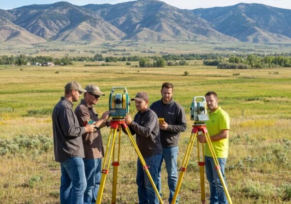
Traditional tools like theodolites, total stations, and levels have been used for many years in construction surveying. These tools are essential for measuring angles, distances, and elevations with high precision.
Theodolites are vital in construction surveying. They measure both horizontal and vertical angles, which are critical for determining property boundaries, building layouts, and more. Their precision makes them indispensable, even with advancements in modern technology.
Levels, particularly builder’s levels and dumpy levels, are another cornerstone of traditional surveying. They help in determining the height of points on a construction site relative to a specific reference point. Ensuring that different points on a construction site are level is crucial for the stability and safety of structures.
While many consider these tools old-fashioned, their reliability and precision have kept them in use even today. They offer a certain robustness and simplicity that modern electronic tools can’t entirely replace.
Modern Surveying Equipment
Modern surveying equipment includes advanced technologies like GPS devices, laser scanners, and drones. These tools have revolutionized the way surveyors collect and analyze data, making the process faster and more accurate.
GPS devices are particularly popular for their ability to provide precise location data in real time. This is invaluable for projects that require a high level of accuracy, such as road construction and large-scale property developments.
Laser scanners, often used for 3D modeling, capture detailed topographic data with incredible accuracy. This data is then used to create precise 3D maps and models, which are essential for complex construction projects.
Drones offer a bird’s-eye view of construction sites, making it easier to survey large areas and difficult terrains. Equipped with high-resolution cameras and GPS, drones can capture detailed aerial images and videos Construction Dive provides news and analysis for construction industry executives.
These modern tools not only enhance accuracy but also significantly speed up the surveying process, allowing for real-time adjustments and more efficient project management.
Software and Data Processing Tools
In addition to physical tools, surveyors also use specialized software for data processing and modeling. Examples include CAD software, GIS systems, and other data analysis programs that help in creating detailed maps and construction plans.
CAD (Computer-Aided Design) software is widely used for designing and modeling construction projects. It allows surveyors to create precise drawings and 3D models, which are essential for planning and visualizing complex projects.
GIS (Geographic Information Systems) is another critical tool in construction surveying. GIS integrates various data types and provides a platform for analyzing and visualizing spatial information. This is particularly useful for large-scale infrastructure projects where multiple data sources need to be analyzed together.
Software tools like these are essential for transforming raw data collected in the field into usable information. They enable more accurate planning, better decision-making, and efficient project execution. For more detailed information on the different types of land surveys used in civil engineering Ludlow Engineering – What Are the Different Types of Land Surveys Used in Civil Engineering?.
Safety and Maintenance of Surveying Tools
Proper maintenance and safety practices are crucial when using surveying tools. Regular calibration, cleaning, and safe handling ensure that the tools remain accurate and reliable over time.
Calibration is essential for maintaining the accuracy of surveying tools. Instruments should be checked regularly to ensure they are providing correct readings. This is especially important for high-precision tools like theodolites and total stations.
Proper storage and handling are equally important. Surveying instruments should be stored in protective cases when not in use and transported carefully to avoid damage. Keeping these tools clean and free of dust and debris can also prevent wear and tear.
Safety is another critical consideration What Are the Different Types of Land Surveys Used in Civil Engineering?. Surveyors must follow safety guidelines when working on construction sites, including wearing appropriate personal protective equipment (PPE) and being aware of potential hazards. Ensuring both the safety of personnel and the integrity of the tools can help avoid costly mistakes and accidents.
In summary, the maintenance and safety of surveying tools are essential not only for the longevity of the instruments but also for the overall success of the construction projects. Properly maintained and safely handled tools ensure accurate measurements, which are the backbone of quality construction work.
Wrapping Up: The Importance of Surveying Tools
Construction surveying is a fundamental aspect of the construction industry, and the tools used play a major role in ensuring the accuracy and quality of the work. From traditional levels to advanced GPS systems, each tool has its unique function and importance. With the right tools and knowledge, surveyors can perform their tasks efficiently and effectively, contributing to the overall success of construction projects.