Corner Markers & Property Lines — How Surveyors Re‑Establish Boundaries in Alpine, UT
Understanding property lines and corner markers is essential for any landowner in Alpine, UT. These features define where ownership begins and ends, and they matter for real estate deals, development, and resolving disputes. Below we explain how professional surveyors re‑establish boundaries, which Utah regulations apply, and the modern tools used in the field. We also cover common causes of boundary conflicts and practical steps owners can take to resolve them. By the end, you’ll have a clear, usable picture of how property lines and corner markers work in Alpine.
What Are Property Lines and Corner Markers in Alpine, UT?
Property lines are the legal limits that separate one parcel from another. They’re determined from a mix of historical records, legal descriptions, and field surveys. Knowing your property lines matters because they define your rights and responsibilities as an owner and help you avoid encroachment or permitting issues.
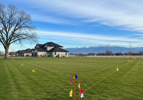
Corner markers are the physical points placed at a parcel’s corners to show those limits on the ground. Markers can be iron pins, concrete monuments, wooden stakes, or other durable materials. Because they’re tangible evidence of a boundary, corner markers often play a central role in resolving disputes or confirming a survey’s findings.
How Do Property Lines Define Land Boundaries?
Property lines set the legal extent of a parcel by tying written descriptions to points on the ground. Surveyors combine historical documents, deeds, and measured fieldwork — distances, angles, and control points — to convert the legal description into an on‑the‑ground boundary. Those lines affect what you can build, where you can place fences, and where access or easements lie.
When lines are unclear or conflicting, legal questions can follow. That’s when a licensed surveyor is typically brought in to reconcile records, locate original monuments, and produce an authoritative boundary for use in negotiations or court.
What Is the Role and Legal Significance of Corner Markers?
Corner markers serve as the field reference for otherwise abstract property descriptions. Because they can be located, measured, and shown on a map, markers often carry legal weight in boundary determinations. Typical marker types include iron pins set in the ground, concrete monuments, and wooden or metal stakes placed during surveys.
In disputes, a properly documented corner marker — shown on a certified boundary survey — provides practical proof of where a boundary lies. Keeping markers visible and documented reduces confusion between neighbors and streamlines property transactions.
How Do Surveyors Re-Establish Property Boundaries and Corner Markers?
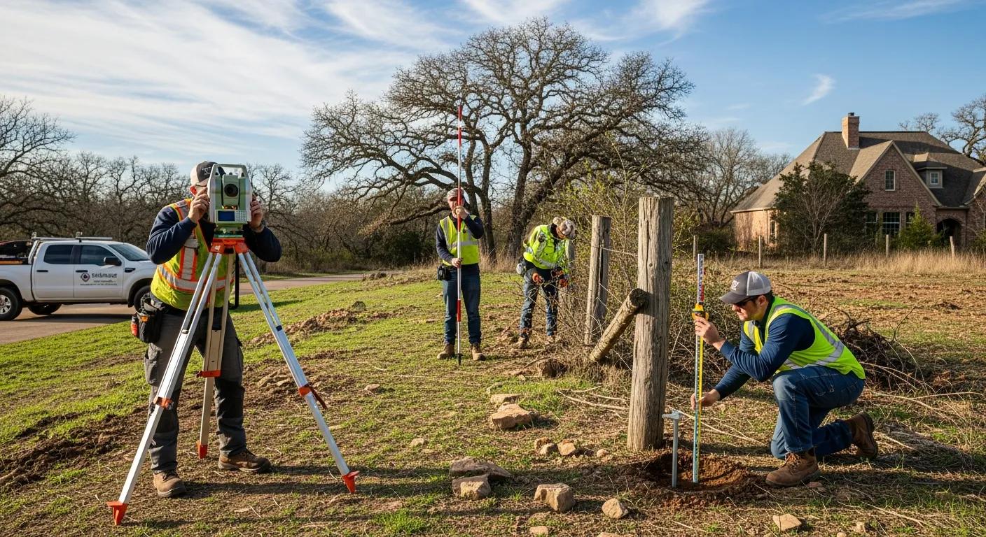
Re‑establishing boundaries is methodical work. Licensed surveyors follow a series of steps to ensure the result is accurate, defensible, and compliant with Utah standards. The process balances documentary research with precise field measurement.
What Are the Steps in a Boundary Survey for Property Line Determination?
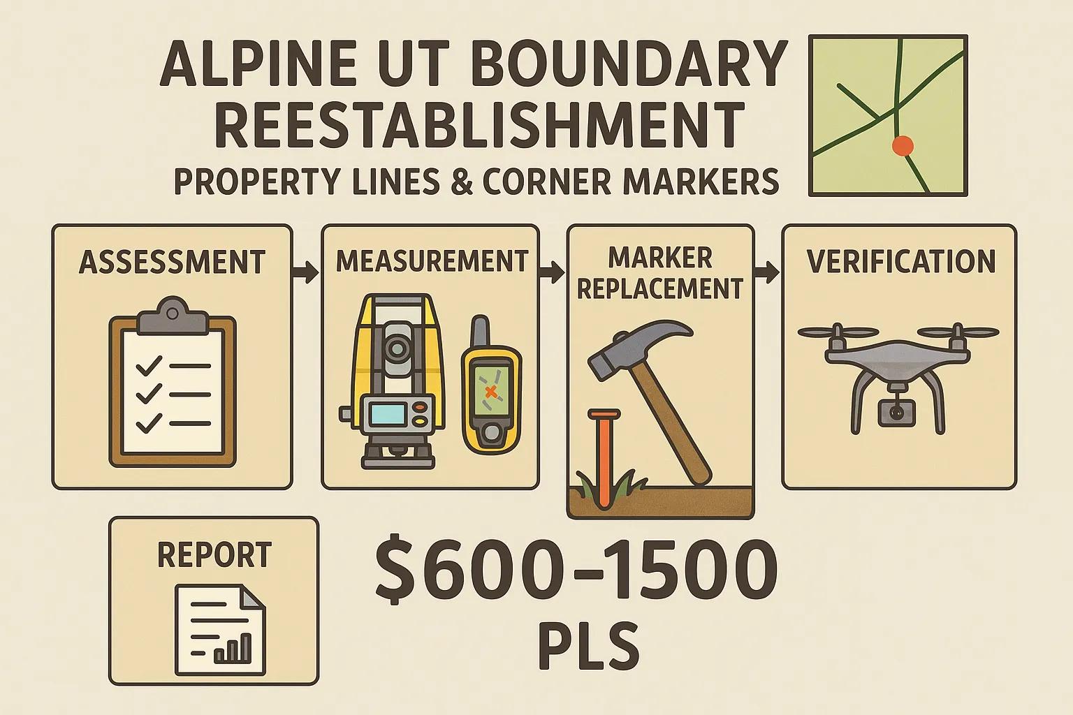
A boundary survey commonly follows these steps:
- Initial Assessment: We review deeds, plats, previous surveys, and other records to understand the parcel history and any existing monumentation.
- Measurement Techniques: In the field, surveyors use total stations, GNSS/GPS, and control ties to measure distances and angles that locate corners and lines with precision.
- Final Report Preparation: The project concludes with a detailed survey map, a written report noting corner locations and any discrepancies, and certified documentation you can rely on.
This sequence ensures boundaries are re‑established in a repeatable, legally sound way and gives property owners the documentation they need.
How Are Corner Markers Accurately Replaced and Verified?
When a corner marker is missing or damaged, surveyors reconstruct its position using records and measured control. The usual approach includes:
- Locating Original Markers: Using historical plats, deed calls, and surviving monuments to identify where corners were originally set.
- Replacement Techniques: Installing new, durable markers (iron, concrete, or approved monuments) at the re‑established corner locations.
- Verification Tools: Confirming positions with GPS/GNSS and total station measurements and documenting the work on the final plat.
Accurate replacement and careful documentation preserve the property’s boundary integrity and reduce future disagreements.
What Legal Regulations Govern Boundary Surveys in Utah and Alpine?
Boundary surveys in Utah are subject to state statutes and local rules that protect property rights and set professional standards. Surveyors must follow licensing requirements and technical standards when preparing surveys that will be used for legal or permitting purposes.
Which Utah State Land Survey Laws Affect Property Boundary Reestablishment?
Key legal frameworks include:
- Utah Land Survey Act: Governs the practice of land surveying in the state and sets standards for licensed surveyors.
- Boundary Law: Provides the legal principles used to resolve competing claims and interpret deeds and monuments.
These statutes ensure surveys are performed by qualified professionals and that results are defensible in legal or administrative proceedings.
How Do Surveyors Ensure Compliance with Local Alpine Jurisdiction?
Local rules in Alpine — zoning, platting requirements, and permit conditions — can affect survey scope and deliverables. Surveyors coordinate with city or county officials as needed, secure required permits, and format plats and certificates to meet local filing standards. That local compliance keeps your survey valid for permitting, development, or recordation.
What Modern Technologies Do Surveyors Use in Alpine Boundary Surveys?
Modern tools have made boundary surveys faster and more accurate. In Alpine, survey teams commonly combine GNSS/GPS, total stations, and drones to capture positional data and site imagery efficiently.
How Does GPS and Drone Technology Improve Survey Accuracy?
GNSS/GPS provides precise coordinate data that anchors surveys to state or national reference frames, while drone surveys capture aerial imagery and elevation data that help map features and terrain. Together, these technologies allow surveyors to verify corner locations, model topography, and produce plans with a high degree of confidence.
Research comparing measurement systems further underscores why precise control and repeated observations matter when establishing legal boundaries.
DGPS & Total Station Accuracy for Property Boundary Surveys
A control survey establishes the positions of points with a high level of accuracy to support activities like mapping, boundary surveys, and construction. This study compares coordinates determined using dual‑frequency GPS and Total Station equipment to evaluate their relative accuracies.
Comparative Evaluation of The Accuracies of Differential GPS and Total Station in Determining the Coordinates of Existing Controls, JI Igbokwe, 2021
What Tools and Equipment Are Essential for Land Surveyors in Utah?
Essential survey equipment includes:
- Total Stations: For precise angle and distance measurements on the ground.
- GPS Receivers: GNSS units for accurate positioning tied to control networks.
- Drones: For aerial imagery, site visualization, and efficient data collection over larger or difficult terrain.
Using these tools together helps deliver reliable, well‑documented boundary surveys.
How Can Property Owners Resolve Boundary Disputes in Alpine, UT?
Boundary disagreements are common but usually resolvable. Understanding the typical causes of disputes and the role of a professional survey can help you address issues calmly and effectively.
What Are Common Causes of Property Line Disputes?
Typical causes include:
- Misunderstandings: Neighbors may interpret maps, verbal agreements, or historical placements differently.
- Legal Issues: Ambiguous deed language, lot splits, or title changes can cloud where lines lie.
- Neighbor Disputes: Physical improvements, fences, or landscaping that encroach across an unclear boundary.
Recognizing these causes early makes it easier to take corrective action before a dispute escalates.
How Do Boundary Surveys Help in Dispute Resolution?
A boundary survey provides an impartial, documented determination of where lines and corners are located. That survey can be used to support negotiations, clarify misunderstandings, or serve as evidence in legal proceedings when necessary. In many cases, a certified survey brings neighbors to a quick, amicable resolution.
What Are the Typical Costs and Certification Requirements for Surveyor Services in Alpine?
Knowing typical costs and the credentials to look for helps you select the right surveyor for your needs.
How Much Does a Land Boundary Survey Cost in Alpine, UT?
Survey costs vary with property size, complexity, and the presence of disputes. In Alpine, typical comprehensive boundary surveys range from about $600 to $1,500. Price factors include:
- Property Size: Larger parcels require more field time and data processing.
- Survey Complexity: Irregular boundaries, difficult terrain, or conflicting records increase effort.
- Surveyor Experience: Licensed, experienced surveyors deliver reliable results and documentation.
What Certifications Must Professional Surveyors Hold in Utah?
Qualified surveyors in Utah must be licensed and maintain current professional education. Key credentials include:
- Licensed Professional Land Surveyor (PLS): Required to perform and certify boundary surveys in Utah.
- Continuing Education: Ongoing training ensures surveyors stay current with technology and legal standards.
Choosing a licensed surveyor helps ensure your survey meets legal and technical expectations.
Conclusion
Clear property lines and properly documented corner markers protect your ownership and simplify transactions or development. Working with a licensed surveyor ensures boundaries are re‑established accurately and in line with Utah and local Alpine standards. If you have questions about a specific property, our team can explain the process, estimate costs, and provide the certified survey documentation you need. Discover more about our surveying services and how we can assist you today.