Ludlow Engineering logo, representing a land surveying company in Utah, associated with land survey cost variations and related services.

Commercial Land Survey Cost in Utah (2026) | Ludlow


Drone hovering above a commercial property in Nephi, Utah, capturing aerial imagery for an ALTA survey, showcasing urban landscape and buildings.
Home  ›  Survey Costs  ›  Commercial Survey Fees
Commercial surveying · Statewide Utah · 2026 pricing

Commercial Land Survey Cost in Utah

What commercial ALTA, boundary, topographic, site-plan and construction surveys cost in Utah, what drives the fee, and which survey your transaction actually needs.

Short answer: commercial boundary surveys start around $1,800, ALTA/NSPS surveys start at $3,000, and most financed commercial transactions land between $3,000 and $15,000 depending on parcel size, Table A items and records. Ludlow quotes every commercial survey as a fixed fee in writing.
$1,800+ Commercial boundary surveys
$3,000+ ALTA / NSPS surveys
2–6 weeks Typical commercial turnaround
Fixed fee Scope & deliverables in writing
Start with the transaction

How Much Does a Commercial Land Survey Cost?

The price depends less on the word “commercial” than on what the survey has to prove, and to whom. If a lender or title insurer is involved, you’ll almost always need an ALTA/NSPS survey, and the Table A items they select drive most of the cost. If you only need lines for a split, a fence or a dispute, a commercial boundary survey costs far less. Building or renovating adds topography and a site-plan survey. The table below shows typical 2026 ranges by transaction.

01 · 2026 Utah planning ranges

Commercial Survey Cost by Transaction

Typical ranges for Utah commercial work. Your fixed-fee quote will be specific to the parcel, the title commitment and the lender’s scope.

Your TransactionSurvey NeededTypical Cost
Buying commercial property with bank financingALTA/NSPS Land Title Survey$3,000–$18,000+
Refinancing commercial propertyALTA update or re-certification$600–$4,500
Owner-financed commercial purchaseBoundary survey (ALTA optional)$1,800–$3,500
Splitting a commercial parcelBoundary survey + plat or lot-line adjustment$2,500–$6,000+
Building a new commercial structureBoundary + topographic / site-plan survey$3,500–$9,000
Major addition or renovationTopographic + site-plan survey$2,500–$6,000
Site-plan approval or zoning applicationSite-plan survey$3,500–$8,000
Development due diligenceALTA + topographic (often drone-led)$5,000–$15,000+
Commercial boundary disputeBoundary survey (sometimes ALTA)$2,000–$5,500+
1031 exchange acquisitionALTA/NSPS Land Title Survey$3,000–$12,000
ConstructionConstruction staking + as-builtProject-based
02 · Know what you’re buying

Commercial Survey Types & What Each Costs

Each is prepared in-house and stamped by a Utah Professional Land Surveyor. Many commercial projects combine two or more in a single field effort.

Lender & title

ALTA / NSPS Land Title Survey

Boundary plus the Table A items your lender and title insurer select: utilities, easements, encroachments, flood zone, zoning and parking. The default for financed purchases and refinances. Starts at $3,000.

ALTA Surveys →
Lines only

Commercial Boundary Survey

Sets the corners and legal boundary without Table A documentation. Fits owner-financed deals, lot splits and disputes where no lender requires an ALTA. Starts around $1,800.

Boundary Surveys →
Design

Topographic Survey

Elevations, contours and surface features for the architect and civil engineer. Usually $1,500–$6,000 standalone, less when combined with the boundary or ALTA fieldwork.

Topographic Surveys →
Approval

Site Plan Survey

Boundary, topography and existing features combined into the base for municipal site-plan review, zoning and building permits.

Site Planning →
Construction

Staking & As-Built

Building, utility, curb and grade staking during construction, then an as-built survey that shows what was actually built. Priced by the project.

As-Built Survey Costs →
Flood zones

Flood & Floodproofing Certificates

FEMA elevation certificates for commercial buildings in flood zones, and the data behind floodproofing certifications for non-residential structures.

Flood Certificates →
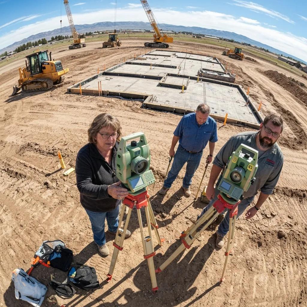
Surveyors conducting an ALTA survey on a commercial construction site in Payson, Utah, using total stations, with construction equipment and foundation forms visible in the background.
Commercial vs. residential

Same Instruments. Bigger Scope.

A commercial survey uses the same methods as a residential one, but it answers to more people: a lender, a title insurer, a city reviewer and often an attorney. Larger parcels, dense utilities, recorded easements and higher liability are why the fee is higher.

03 · Inside the number

What a Commercial Survey Fee Pays For

Every commercial quote is built from the same four pieces. Knowing them makes it easier to see why two quotes differ.

Research

Records & Title Review

Deeds, plats, prior surveys and every exception in the title commitment, checked before fieldwork.

Field

Crew Time & Equipment

Locating corners, improvements, utilities and features with GNSS, total station or drone.

Office

Drafting & Certification

Calculations, the survey drawing, Table A notes and the surveyor’s certification to the named parties.

Travel

Mobilization

Getting crew and equipment to the site, shown as its own line on our quotes.

04 · Why quotes vary

Six Factors That Raise or Lower the Fee

These move a commercial survey up or down the ranges in the table above.

Size

Parcel Size & Shape

More acreage and more boundary courses mean more corners to recover and more ground to map.

Scope

Table A Items

Each optional item, such as utilities, zoning, parking counts or building dimensions, adds field or office time.

Records

Record Quality

Clean recent plats speed things up; old metes-and-bounds deeds and conflicting surveys slow them down.

Density

Improvements & Utilities

Shopping centers and industrial sites with many buildings, utilities and easements take longer to map.

Site

Terrain & Access

Steep ground, active operations, traffic and restricted areas add time and safety measures.

Schedule

Closing Date

Expedited delivery means overtime or extra crews, priced at a premium.

Drone surveying technology and a surveyor using a total station in a mountainous landscape, with computer screens displaying topographic maps and data analysis for land surveying applications.
05 · Drone-led commercial surveys

Where a Drone Lowers the Price.

On commercial parcels of about 5 acres or more, we fly the site with FAA Part 107 pilots and use ground crews to verify control and capture what the drone can’t see.

Shorter fieldwork: about 1 day instead of 2–4 on larger parcels.
Lower cost: typically 15–30% less on parcels of 5+ acres.
Faster delivery: ALTA work in about 3–4 weeks instead of 4–6.
More data: a scaled orthomosaic and point cloud for your design team.
Safer: no crew walking active industrial sites or traffic corridors.
Not always: small, dense urban or restricted-airspace sites stay ground-based.
06 · Avoid surprises

Costs That Can Be Added Mid-Project

These are the usual reasons a commercial survey bill grows. Most can be avoided by settling scope before the quote.

Records

Boundary Discrepancies

Gaps, overlaps or conflicting surveys that need extra research before the surveyor can certify the line.

Utilities

Private Utility Locating

Blue Stakes marks public lines only. Private lines on large sites may need a locating subcontractor.

Scope creep

Table A Items Added Late

A lender who adds items after the quote adds field and office time.

Title

Revised Title Commitments

New exceptions mean new documents to plot and a revised drawing.

Schedule

Expedited Delivery

A closing date inside the normal timeline is possible, at a premium.

Construction

Re-Staking

Stakes or monuments knocked out by equipment have to be reset.

07 · Before you sign

How to Compare Commercial Survey Quotes.

Two commercial quotes can differ by thousands of dollars simply because they cover different work. Before comparing price, line up the scope: the same Table A items, the same deliverables, the same parties in the certification and the same number of revisions.

A quote from a surveyor who has already read your title commitment is worth more than a lower number from one who hasn’t, because the second one is likely to change.

Ask Every Surveyor

Is it a fixed fee or hourly with reimbursables?
Which Table A items are included, by number?
Have you reviewed the title commitment and exceptions?
Who is certified: buyer, lender, title company?
How many revisions are included after review?
What’s the delivery date, and what does faster cost?
08 · What to expect

How a Ludlow Commercial Survey Works

Scope is settled before fieldwork, so the fee you approve is the fee you pay.

1

Send the Documents

Parcel, title commitment, lender requirements and closing date.

2

Scope & Fixed Fee

Survey type, Table A items and deliverables in writing.

3

Research & Field

Records reviewed, then the crew or drone maps the site.

4

Draft & Review

Draft drawing shared with you, title and lender for comments.

5

Certify & Deliver

Signed, sealed and certified to the named parties.

10 · Direct answers

Commercial Land Survey Cost FAQ

Questions buyers, brokers and developers ask most.

How much does a commercial land survey cost in Utah?

Commercial boundary surveys start around $1,800, and commercial ALTA/NSPS surveys start at $3,000 and can pass $18,000 on large industrial sites. Topographic surveys typically run $1,500–$6,000 standalone. Staking and as-built work is priced by the project. Every Ludlow quote is a fixed fee in writing.

Why does a commercial survey cost more than a residential one?

Commercial deals usually involve a lender and a title insurer, so the survey needs ALTA/NSPS scope rather than a simple boundary. Parcels are larger, improvements and utilities are denser, records are more complex and the liability is higher, all of which add field and office time.

What drives the price of a commercial survey?

Parcel size, the number of Table A items requested, the quality of existing records and prior surveys, how many buildings, utilities and easements must be shown, terrain and site access, travel, and how fast you need it.

What extra costs can come up during a commercial survey?

The most common are boundary discrepancies that need more research, private utility locating beyond Blue Stakes, Table A items added after the quote, revisions when the title commitment changes, expedited delivery and re-setting disturbed monuments. A clear scope up front avoids most of them.

How long does a commercial land survey take?

A commercial boundary survey typically takes 2–4 weeks. An ALTA survey takes about 3–4 weeks when drone-led or 4–6 weeks ground-only, and a topographic survey 2–3 weeks. Expedited schedules are available for an added fee.

How do I compare commercial survey quotes?

Make sure each quote covers the same scope: the same Table A items, deliverables, certification parties and revision rounds. Ask whether it’s a fixed fee, what’s excluded, and whether the surveyor has reviewed your title commitment. The lowest number often leaves items out.

Can drone surveying lower the cost?

On parcels of about 5 acres or more, drone-led fieldwork typically cuts field time and can reduce cost by roughly 15–30%. On small or dense urban sites, ground surveying is usually just as efficient, and we’ll tell you which fits during scoping.

Do you work with title companies, lenders and out-of-state owners?

Yes. We coordinate directly with title officers and lenders to confirm Table A scope, and handle out-of-state clients remotely with electronic delivery of all documents.

Land surveying equipment set up in an open Utah landscape
Commercial Surveying · Statewide Utah · Since 1975

Get a Fixed Commercial Survey Fee.

Send the property, the title commitment and the lender’s requirements. We’ll identify the right survey and send a fixed-fee proposal within 1–2 business days.

Who's behind this page

Licensed Utah Surveyors & Engineers Since 1975.

Ludlow Engineering has surveyed and engineered Utah property for 51 years. Every survey and plan is prepared under a licensed professional, not handed off.

Daryl Penrod

Professional Land SurveyorState of Utah No. 5331527

Directs our boundary, topographic, ALTA and subdivision surveys.

J. Brett Ludlow

Professional EngineerState of Utah

Stamps our site plans, foundation designs and civil engineering.

Travis Ludlow

Partner & Managing MemberMBA

Managing Member of Ludlow Engineers and Associates

Since 197551 years, family-run in Nephi
5,606projects tracked since 2000
1,200+survey maps filed with Utah counties
19 countiesacross Utah where we've worked

Where we work

Projects in 19 Utah counties since 2000, from our office in the center of the state.

Most projects
Sanpete County1,875
Juab County1,862
Utah County631
Millard County123
Salt Lake County81
Recent projects
  • Subdivision & plattingNephi, Juab County
  • Site planSantaquin, Utah County
  • Survey projectPerry, Box Elder County
  • Subdivision & plattingFillmore, Millard County
  • Subdivision & plattingNephi, Juab County

Counts come from Ludlow Engineering's project records (2000–present, updated Oct 2026). Client names are never shown.