

Salt Lake City Land Surveyors: Your Complete Guide to Boundary Surveys
Accurate land surveying is the foundation of responsible property ownership, development, and dispute resolution in Salt Lake City. This guide explains what professional land surveying involves, why it matters for homeowners, developers, and lenders, and how licensed surveyors deliver reliable plats, digital deliverables, and legal documentation. Readers will learn the main survey types used across Salt Lake City, step-by-step process expectations, transparent cost drivers, and how to request a formal quote from a licensed surveyor. The article also covers decision criteria for hiring local professionals, the benefits surveys provide for commercial and residential projects, and the latest technologies—UAVs, LiDAR, GNSS—that are reshaping local practice. Throughout, keyword-relevant terms like land surveyors in Salt Lake City, boundary survey Salt Lake City, and ALTA survey Salt Lake City are used to help homeowners and project managers find practical, actionable guidance.
What Are the Main Types of Land Surveying Services in Salt Lake City?
Main surveying services in Salt Lake City include boundary, ALTA/NSPS land title, topographic, construction staking, and other specialty surveys that support legal, development, and construction needs. These survey types map property corners, elevations, improvements, and easements so owners and professionals can make informed decisions. Understanding the practical use case for each survey helps clients choose the right scope and deliverables for title work, permitting, or site design. The short comparison table below contrasts typical outputs and turnaround expectations to help readers decide which survey fits their immediate goals.
This table compares common survey types, their typical uses, and example outputs or timing.
The table highlights how each survey maps to client goals: boundary work for legal certainty, ALTA for commercial closings and insurance, and topo for design. The next subsections explain boundary and ALTA surveys in practical Salt Lake City contexts.
What Is a Boundary Survey and Why Is It Important?
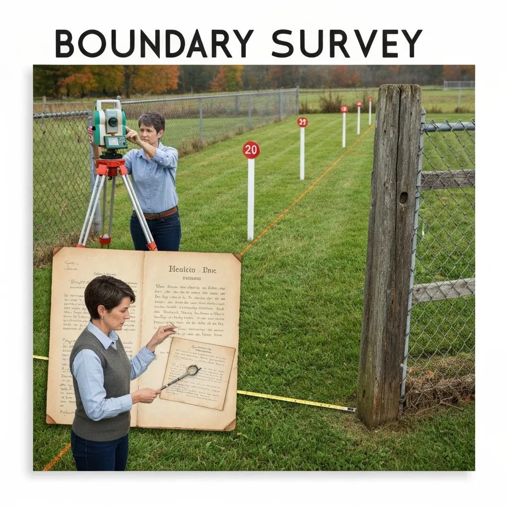
A boundary survey establishes the legal limits of a parcel by researching deeds, plats, and field evidence, then physically locating monuments and producing a certified plat. This process matters because property owners, builders, and local authorities rely on certified plats to verify setbacks, resolve encroachments, and support property transfers. Deliverables typically include a signed survey plat, field notes, monumentation, and records of evidence used to determine lines. In Salt Lake City contexts, local cadastral records and municipal setback rules can influence research complexity and the need for coordination with planning staff.
Boundary surveys often precede construction or sale to avoid later disputes. Accurate monumentation and a clear surveyor’s certificate create evidence that can be used in legal or title matters, which is why many clients prioritize professionally stamped plats.
How Do ALTA Surveys Support Commercial Real Estate in Salt Lake City?
An ALTA/NSPS land title survey follows national standards to meet lender and title company requirements for commercial real estate due diligence and insurance underwriting. ALTA surveys combine boundary evidence with recorded easements, rights-of-way, and visible improvements, producing a standardized report that stakeholders use to assess risk. Typical ALTA deliverables include a certified plat, exception lists, and any requested surveyor certifications or endorsements required by title insurers. For Salt Lake City commercial transactions, the ALTA process often involves coordination with local utilities and review of municipal records to ensure all encumbrances and access routes are documented.
Because ALTA surveys are tailored to insurance and closing needs, they commonly require additional research and verification steps that affect timeline and cost. Understanding those requirements upfront reduces surprises during escrow and eases lender sign-off. ALTA surveys
How Does the Land Surveying Process Work in Salt Lake City?
A typical survey engagement starts with client intake and records research, moves through field data collection and monumentation, and finishes with drafting, certification, and delivery of digital and paper deliverables. This sequence ensures legal defensibility and practical utility for permitting, design, or transaction purposes. Clients should expect clear milestones: proposal and scope, on-site survey, draft plat review, and final stamped deliverables. The following EAV table maps steps to deliverables and typical timeframes so readers can set realistic expectations.
The table below maps common process steps to actions and deliverables so clients understand what to expect at each phase.
This stepwise mapping clarifies responsibilities and timings, helping clients plan permitting or closing windows. Below are the specific steps for a boundary survey and the technologies commonly used by Salt Lake City land surveyors.
What Are the Steps Involved in a Typical Boundary Survey?
A boundary survey typically begins with records research—examining deeds, prior plats, and title commitments—to form a legal basis for fieldwork. Field verification follows, using measurements to locate evidence such as monuments, fences, and improvements; surveyors reconcile field evidence with written records to close the boundary. Monumentation may be set or documented, and a certified plat is drafted showing bearings, distances, and any discrepancies or encroachments. Final deliverables usually include the signed plat, field notes, and digital files suitable for planners or title companies.
Understanding these steps helps property owners prepare documents like deed copies and current title commitments, which can shorten the research phase and reduce overall cost. The next section explains technologies that speed and improve accuracy for these tasks.
Which Technologies Are Used by Salt Lake City Land Surveyors?

Modern surveying relies on GNSS/GPS for rapid control points, robotic total stations for precise horizontal and vertical measurements, UAV photogrammetry for broad-area mapping, and LiDAR/3D laser scanning for high-resolution point clouds. These technologies produce deliverables such as CAD files, GIS layers, orthophotos, and point clouds that support BIM integration and design workflows. Surveyors choose technologies based on site scale, required accuracy, and deliverable format—UAVs for large site mapping, LiDAR for complex structures, and GNSS for long-range control.
Using these tools reduces field time and improves deliverable fidelity, which benefits permitting and contractor coordination. As a practical example, some multidisciplinary firms combine in-house engineering and surveying teams to convert survey outputs directly into site plans and construction documents.
How Much Does a Land Survey Cost in Salt Lake City?
Survey pricing varies by type, parcel size, site complexity, and required deliverables, but clients can expect transparent cost drivers rather than fixed nationwide prices. Common price influences include acreage, terrain, research complexity, required accuracy, and whether ALTA endorsements or digital deliverables are needed. The EAV table below breaks down primary cost factors and typical impacts to help readers estimate relative pricing before requesting a formal quote.
Understanding cost drivers helps clients plan budgets and scope responsibly. land and property survey costs
This breakdown shows why two nearby parcels can have different estimates and which choices control budget. The next subsection lists common pricing drivers in practical terms. You can find more information on land and property survey costs.
What Factors Influence the Cost of Boundary and ALTA Surveys?
Key variables include the survey type (boundary vs ALTA vs topographic), the amount of deed and title research required, site access and terrain, and the level of deliverable detail or endorsements requested. For example, an ALTA survey that requires endorsements for title insurance typically incurs more research and coordination than a straightforward boundary survey. Field conditions—such as dense brush or obstructed sight lines—may necessitate UAV or 3D scanning, which affects labor and equipment costs. Lastly, turnaround time expectations and the need for additional digital outputs (GIS layers, CAD files, point clouds) influence final pricing.
Knowing these drivers allows clients to tailor scope to budget—for example, limiting deliverables to a certified plat for a quick dispute resolution versus commissioning a full ALTA with digital layers for a commercial closing. The following subsection explains how to request a quote and what to include to get an accurate estimate.
How Can You Request a Quote from a Licensed Land Surveyor in Salt Lake City?
To request an accurate quote, prepare the property address or legal description, a recent deed or title commitment, and a clear statement of intended use (sale, construction, permitting, or financing). Submit these materials and ask for a written scope that lists deliverables, timeline, and any assumptions about access or research. Expect a preliminary estimate within a few business days and a site visit scheduled to refine pricing if necessary. For those considering a local multidisciplinary provider, Ludlow Engineering and Associates is an available resource with surveying and civil engineering services across Utah; contact them via their website contact page to request a scope and estimate.
Providing clear documentation up front speeds estimates and reduces scope change risk. A concise request with the items above leads to faster, more reliable quotes and clearer project scheduling.
Why Choose Local Licensed Land Surveyors in Salt Lake City?
Hiring a local licensed surveyor ensures compliance with Salt Lake City and Salt Lake County regulations, faster permitting coordination, and knowledge of local record sources that affect boundary and easement determinations. Local professionals understand municipal standards, typical easement patterns, and planning division requirements, which reduces rework during permitting or transaction closing. Trust signals to evaluate include licensure, demonstrated in-house engineering capacity, transparent deliverables, and professional integrity in reporting. The short bulleted list below summarizes key buyer criteria when selecting a local survey provider.
- Licensed professional land surveyor authorization and proof of compliance with state requirements.
- Clear examples of deliverables such as certified plats, CAD/GIS files, and point clouds.
- Demonstrated ability to coordinate with local planning departments and title companies.
- Transparent communication on scope, assumptions, and timelines.
After weighing criteria, the next paragraph highlights specific trust signals that local clients often rely on when choosing a firm.
What Experience and Credentials Should You Look For?
Clients should verify that the provider uses licensed professional surveyors and has credentials or affiliations indicating professional practice standards, and ideally has civil engineering capabilities in-house to streamline site-plan workflows. Evidence of competency includes sample stamped plats, clear descriptions of deliverables, and references from recent projects—especially projects similar in scale or regulatory context to the client’s needs. For complex commercial work, look for teams that can deliver GIS layers, CAD files, and coordinate with title and permitting stakeholders. These items reduce friction and improve the quality of outcomes for owners and developers.
Assessing credentials early reduces the risk of incomplete deliverables or the need to re-engage another firm later in the project lifecycle. The next subsection explains why client service and integrity are essential.
How Does Client Satisfaction and Integrity Impact Surveying Services?
Client satisfaction depends on clear communication of scope, assumptions, and realistic timelines, while integrity ensures survey results are defensible and accurately reported. Transparent reporting of uncertainties, visible record-keeping, and consistent client updates prevent disputes and costly delays. Ethical practice also affects legal defensibility—accurate monuments and certified plats are central to resolving boundary disagreements or supporting title insurance claims. Firms that prioritize integrity reduce downstream legal exposure and foster long-term client relationships built on trust.
Choosing a provider that emphasizes responsiveness and clear documentation leads to smoother projects and fewer surprises during permitting or closing.
What Are the Benefits of Commercial and Residential Land Surveys in Salt Lake City?
Land surveys reduce risk, support efficient design and permitting, and create a permanent, defensible record of property conditions and legal limits for both residential and commercial projects. For developers, surveys inform grading, utility routing, and site layout decisions; for homeowners, surveys clarify setbacks, detect encroachments, and provide legal documentation for sales or refinancing. Surveys also streamline construction by providing accurate control for contractors and reducing rework from mislocated features. Below is a concise checklist of practical benefits that owners and professionals can expect from a completed survey.
This checklist summarizes primary advantages of commissioning professional surveys.
- Risk Reduction: Identifies encroachments, easements, and title exceptions that could affect transactions.
- Improved Planning: Provides elevations and improvements needed for site design, grading, and permitting.
- Construction Efficiency: Supplies staking and control data that minimize errors and rework during construction.
After benefits come specific applications in development and dispute contexts, explained next.
How Do Land Surveys Facilitate Property Development and Construction?
Surveys provide the topographic baseline, boundary control, and construction staking necessary to translate design into buildable work, ensuring correct placement of foundations, utilities, and site grading. Accurate elevation data and contour mapping reduce earthwork errors and support stormwater design and permitting. Construction staking converts plan coordinates to physical guide points on-site, enabling contractors to construct within designed tolerances. These survey outputs improve contractor efficiency, reduce change orders, and help projects meet municipal approvals more predictably.
By integrating survey deliverables with civil engineering workflows, project teams can move from concept to permit-ready documents faster and with fewer iterations. The following subsection describes surveys’ role in legal and easement issues.
What Role Do Surveys Play in Resolving Property Disputes and Easements?
A professionally prepared survey documents boundary evidence, improvements, and recorded encumbrances, creating the factual record used in dispute resolution, settlement negotiations, or court proceedings. Survey plats identify easement locations, dimensions, and relationships to improvements, which clarifies use rights and access. In cases of encroachment or uncertain title lines, surveyors reconcile physical evidence with deed descriptions to recommend practical resolutions such as monument resetting or agreed easement boundaries. This evidence-based approach supports legal processes and reduces prolonged conflicts.
Accurate, certified documentation is often required to finalize settlements or obtain title insurance endorsements, making timely surveys an important tool in dispute and easement management.
What Are the Latest Trends and Technologies in Salt Lake City Land Surveying?
Recent trends emphasize faster, higher-resolution data capture and seamless digital deliverables: UAV photogrammetry for rapid site mapping, 3D laser scanning for complex structures, GNSS control networks for precise positioning, and delivery of CAD, GIS, and point-cloud files for integration with BIM and civil design. These technologies improve survey accuracy, reduce field hours, and create datasets usable across design and construction teams. Local standards and clients increasingly request digital formats that plug directly into permitting and modeling workflows. The next sections compare UAV and LiDAR benefits and summarize local standards affecting surveys.
How Are UAVs and 3D Laser Scanning Improving Survey Accuracy?
UAV photogrammetry enables rapid coverage of large sites with orthophotos and contour extraction, while 3D laser scanning produces dense point clouds capturing complex geometry and as-built conditions with high precision. Photogrammetry is efficient and cost-effective for terrain and vegetation mapping, whereas LiDAR/3D scanning excels where structural detail or vertical accuracy is critical. Deliverables from these methods include orthomosaics, contour models, and point clouds that can be supplied to design teams in standard formats for CAD, GIS, or BIM. Choosing the right technology depends on the project’s accuracy needs, site complexity, and deliverable requirements.
Integrating these outputs into civil engineering workflows reduces duplication of effort and accelerates design validation and construction verification.
What Are the Local Regulations and Standards Affecting Land Surveys in Salt Lake City?
Surveyors operating in Salt Lake City follow state licensure requirements and national standards like ALTA/NSPS for title surveys, as well as local planning division rules and permit conditions that affect submittal formats and monumentation standards. Clients should confirm that their surveyor will produce deliverables that comply with municipal submittal criteria and title company requirements. Because local record systems and permitting processes can differ from one jurisdiction to another, working with a surveyor familiar with Salt Lake City and Salt Lake County practices streamlines approvals and reduces rework. Verifying compliance up front avoids delays tied to incompatible file formats or missing certification language. For more information, check out our services.
Regular communication between surveyors, planners, and title stakeholders keeps projects aligned with current regulatory expectations and helps avoid costly resubmissions.
Land surveying in Salt Lake City combines legal rigor, modern geospatial methods, and practical deliverables that enable confident transactions, smooth permitting, and efficient construction. For clients seeking a provider with in-house engineering and surveying capabilities who serves Salt Lake City and statewide projects from a Nephi, Utah base, Ludlow Engineering and Associates is positioned to assist; prospective clients can request a scope and estimate through the firm’s online contact page or by providing deeds and project intent to begin the quoting process.

