

Easement Survey Legal Descriptions for Boundaries & Rights-of-Way
Easement surveys play a crucial role in defining property boundaries and ensuring legal clarity regarding land use. These surveys provide essential documentation that outlines the rights and responsibilities associated with easements, which are legal rights to use another person’s land for a specific purpose. Understanding the intricacies of easement surveys and their legal descriptions is vital for property owners, developers, and legal professionals alike. This guide will delve into the significance of easement surveys, the types of easements that require detailed legal descriptions, and the methodologies employed in conducting these surveys. Additionally, we will explore the standards for legal descriptions, how to interpret easement plats, and common challenges faced during the surveying process.
What is an Easement Survey and Why is a Legal Description Essential?
Easement surveys are specialized surveys that delineate the boundaries and rights associated with easements on a property. These surveys are essential for accurately mapping property lines and ensuring that all parties understand their rights and obligations. A legal description is a precise way of describing a property, which is crucial for legal documentation and dispute resolution. Without a clear legal description, property disputes can arise, leading to costly litigation and confusion over land use.
Defining Easement Surveys and Their Role in Property Boundary Mapping
An easement survey is a detailed examination of a property that identifies the specific areas where easements exist. This survey is critical in property boundary mapping as it provides a clear visual representation of the easement’s location and extent. By accurately defining these boundaries, easement surveys help prevent disputes between property owners and ensure compliance with local regulations.
Key Components of a Legal Description in Easement Documentation
A legal description in easement documentation typically includes several key components: the property’s boundaries, the purpose of the easement, and any relevant measurements or references to landmarks. These elements work together to create a comprehensive understanding of the easement’s scope and limitations, which is essential for legal clarity and enforcement.
Which Types of Easements Require Detailed Survey and Legal Descriptions?
Different types of easements necessitate varying levels of detail in their surveys and legal descriptions. Understanding these distinctions is crucial for property owners and surveyors alike.
Understanding Utility, Access, and Conservation Easements
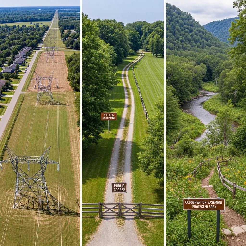
Utility easements allow utility companies to install and maintain infrastructure such as power lines and water pipes. Access easements grant individuals the right to cross another person’s property to reach their own. Conservation easements are designed to protect natural resources and limit development on certain lands. Each type of easement has unique requirements for legal descriptions and surveys, reflecting their specific purposes and implications.
As highlighted by research, utility easements are critical for infrastructure, often involving specific legal descriptions and land use conditions established during land development.
Utility Easements: Legal Descriptions & Land Use Conditions
Easements over utilities on private properties grant the utility providers the right to access that part of the property for reasons noted in the easement agreement and to set land use conditions over the easement. In the world of buried infrastructure, permanent easements, especially for publicly owned sewerage and water distribution systems, are usually dedicated by private property developers when the record plans are submitted for approval during the land development process.
Easements for Utilities on Private Properties, 2005
Similarly, the effectiveness of conservation easements relies heavily on thorough documentation and management plans to ensure their long-term legitimacy and environmental protection.
Conservation Easement Documentation & Legal Language
Demonstrated shortfalls in baseline forest inventories, record keeping, and professionally-developed management plans were evident on working forest easements. Failure to address these shortcomings runs the risk of jeopardizing the legitimacy of the easement approach even where favorable legal and tax conditions exist. Management restrictions varied broadly, with a minority of respondents prohibiting such techniques as clearcutting and salvage logging. Concerns for the use of chemicals, best management practices, and streamside management zones were commonly reflected in easement language, whereas logging road design and the cultivation of old-growth conditions remain largely undeveloped.
A survey of forestland conservation easements in the United States: Implications for forestland owners and managers, 2007
How Easement Types Influence Survey Methods and Legal Descriptions
The type of easement significantly influences the methods used in surveying and the format of the legal description. For instance, utility easements may require more extensive surveying techniques to account for underground installations, while access easements might focus on the pathways and routes used. Understanding these nuances ensures that the legal descriptions are accurate and enforceable.
How Are Easement Surveys Conducted? Survey Methods and Technologies Explained
Easement surveys employ various methods and technologies to ensure accuracy and compliance with legal standards. These techniques are essential for producing reliable survey results.
Traditional, GPS, and Drone Survey Techniques for Easement Mapping
Traditional surveying methods involve physical measurements and the use of tools like theodolites and measuring tapes. In contrast, GPS technology allows for precise location tracking and mapping, enhancing the accuracy of surveys. Drone technology has emerged as a powerful tool for easement mapping, providing aerial views that can capture extensive areas quickly and efficiently.
Integrating GIS and Digital Data in Modern Easement Surveys
Geographic Information Systems (GIS) play a vital role in modern easement surveys by allowing surveyors to analyze and visualize spatial data. This integration of digital data enhances the accuracy of surveys and facilitates better decision-making regarding land use and easement management.
What Are the Standards and Formats for Easement Legal Descriptions?
Legal descriptions must adhere to specific standards and formats to ensure their validity and enforceability. Understanding these standards is crucial for anyone involved in property transactions.
Metes and Bounds vs. Lot and Block: Choosing the Right Format
Legal descriptions can be formatted in two primary ways: metes and bounds, and lot and block. Metes and bounds descriptions use physical landmarks and measurements to define property boundaries, while lot and block descriptions refer to a specific parcel within a recorded subdivision. Choosing the appropriate format depends on the property type and local regulations.
Ensuring Compliance with Local and State Legal Description Standards
Compliance with local and state standards is essential for legal descriptions to be recognized in court. Surveyors must be familiar with these regulations to ensure that their descriptions meet all necessary legal requirements, thereby preventing potential disputes and ensuring the enforceability of easements.
How to Prepare and Interpret Easement Plats and Surveyor Reports?
Understanding how to read and interpret easement plats and surveyor reports is vital for property owners and legal professionals.
Reading and Understanding Plat Maps for Easement Boundaries

Plat maps provide a visual representation of property boundaries and easements. Learning to read these maps involves understanding the symbols and notations used to indicate easement locations and dimensions. This knowledge is crucial for accurately assessing property rights and obligations.
Components of a Surveyor Easement Report and Legal Description
A surveyor’s easement report typically includes detailed information about the easement’s location, dimensions, and purpose. Key components of this report may include the surveyor’s findings, legal descriptions, and any relevant maps or diagrams. Understanding these components helps property owners and legal professionals navigate the complexities of easement documentation.
What Are Common Challenges in Easement Surveys and How to Resolve Them?
Easement surveys can present various challenges that require careful consideration and resolution.
Identifying and Overcoming Boundary Disputes in Easement Surveys
Boundary disputes often arise due to unclear legal descriptions or conflicting survey results. Identifying the root cause of these disputes is essential for resolution. Engaging experienced surveyors and legal professionals can help clarify boundaries and facilitate negotiations between parties.
Case Studies: Successful Easement Survey Resolutions and Client Testimonials
Real-life case studies illustrate the importance of thorough easement surveys in resolving disputes. Successful resolutions often involve clear communication, accurate documentation, and a willingness to collaborate among all parties involved. Testimonials from clients highlight the value of professional easement surveys in achieving satisfactory outcomes.
Different legal description formats serve distinct purposes and are essential for ensuring clarity in property rights.
This comparison highlights the importance of selecting the appropriate legal description format based on the property type and local regulations.
For more information on how professional engineers can assist with your surveying needs, visit Ludlow Engineers.
Frequently Asked Questions
What is the difference between an easement and a right of way?
An easement is a legal right to use another person’s land for a specific purpose, while a right of way is a type of easement that specifically allows passage over someone else’s property. Rights of way are often used for access to landlocked properties or for utility installations. Understanding this distinction is crucial for property owners and developers, as it affects how land can be used and the legal obligations associated with each type of access.
How can property owners ensure their easement rights are protected?
Property owners can protect their easement rights by ensuring that all easements are clearly documented in legal descriptions and recorded with local authorities. Regular communication with neighboring property owners can also help prevent misunderstandings. Additionally, consulting with legal professionals or surveyors can provide guidance on maintaining and enforcing easement rights, especially in the event of disputes or changes in property ownership.
What role do surveyors play in easement disputes?
Surveyors play a critical role in easement disputes by providing accurate measurements and documentation of property boundaries and easement locations. Their expertise helps clarify the legal descriptions and can serve as evidence in legal proceedings. By conducting thorough surveys and producing detailed reports, surveyors assist property owners and legal professionals in resolving conflicts and ensuring compliance with local regulations.
Are there specific regulations governing easement surveys?
Yes, easement surveys are subject to various local, state, and federal regulations that dictate how surveys should be conducted and documented. These regulations ensure that surveys meet legal standards for accuracy and clarity. Surveyors must be familiar with these requirements to produce valid legal descriptions and avoid potential disputes. Compliance with these regulations is essential for the enforceability of easements in legal contexts.
What should I do if I believe my easement rights are being violated?
If you believe your easement rights are being violated, the first step is to gather evidence, such as photographs or documentation of the infringement. Next, communicate with the party involved to discuss the issue and seek a resolution. If informal discussions do not resolve the matter, consider consulting a legal professional who specializes in property law to explore your options for enforcement or dispute resolution.
How often should easement surveys be updated?
Easement surveys should be updated whenever there are significant changes to the property, such as new construction, changes in land use, or alterations to the easement itself. Regular updates help ensure that legal descriptions remain accurate and reflect current conditions. Additionally, property owners should consider updating surveys before any legal transactions or disputes to avoid complications related to outdated information.
Conclusion
Understanding easement surveys and their legal descriptions is essential for property owners and developers to navigate land use rights effectively. These surveys not only clarify property boundaries but also prevent disputes and ensure compliance with local regulations. By engaging with professional surveyors, you can secure accurate documentation that protects your interests. Discover how our expert services can assist you in managing your easement needs today.