
Essential Construction Staking Services for Accurate Site Preparation
Construction staking is a critical process in the construction industry, serving as the foundation for accurate site layout and grade control. This technique involves marking specific points on a construction site to guide the placement of structures, ensuring that they are built according to the approved plans. By utilizing construction staking, project managers can significantly reduce errors and enhance the overall efficiency of construction projects. This article will delve into the importance of construction staking, the techniques and technologies involved, budgeting considerations, common challenges, and how to find reliable services.
What is Construction Staking and Why is it Crucial for Site Survey Services?
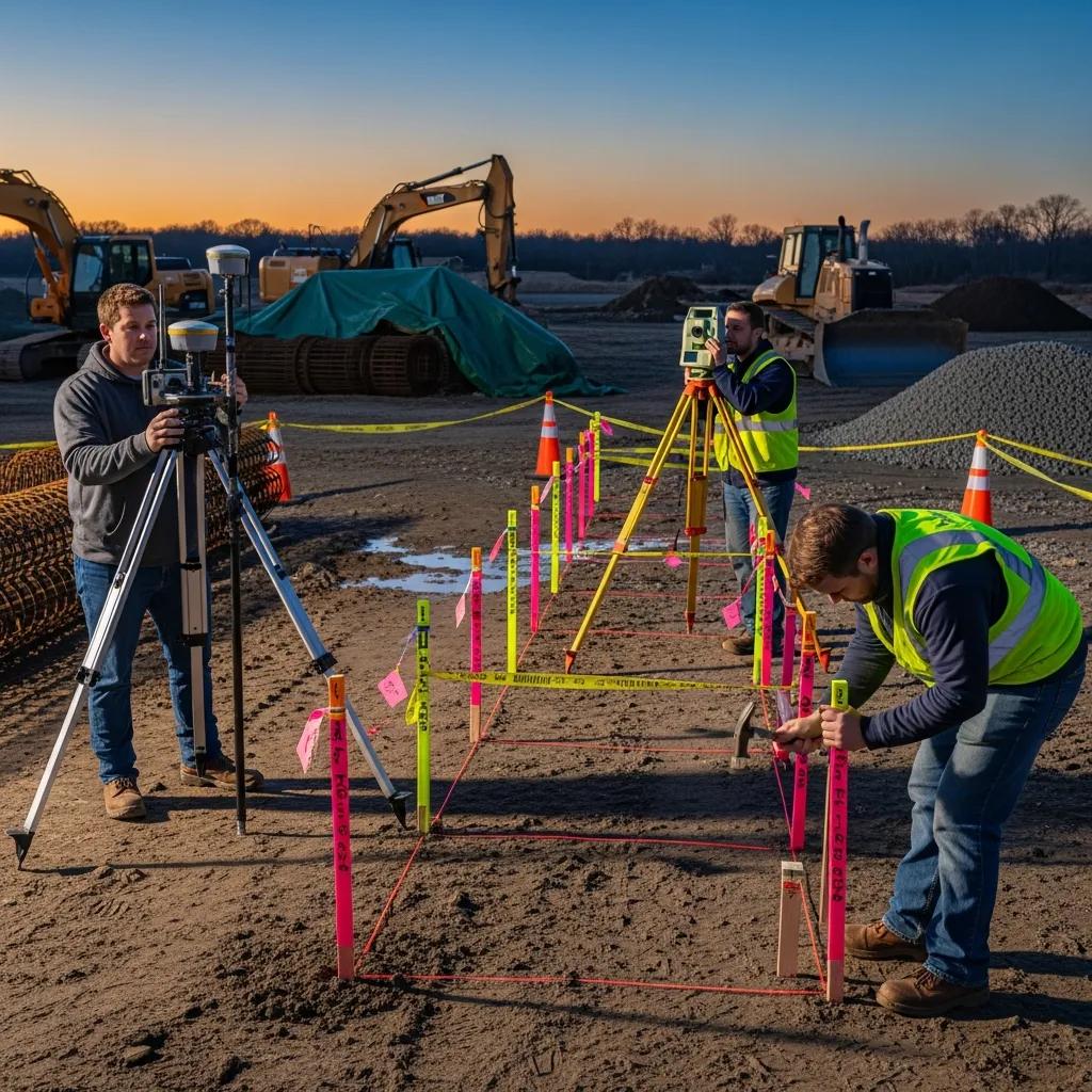
Construction staking is the process of marking the locations of proposed structures on a construction site, which is essential for ensuring that the project adheres to design specifications. This method is crucial for site survey services as it provides a physical reference of where buildings, roads, and other infrastructure will be placed. Accurate construction staking directly impacts the precision of the building layout, which is vital for maintaining compliance with local regulations and standards.
How Does Construction Staking Ensure Accurate Building Site Layout?
Construction staking employs various techniques to ensure that the layout of a building site is accurate. Surveyors use tools such as total stations and GPS technology to determine precise locations for stakes. These stakes serve as reference points for construction crews, guiding them in the placement of foundations and other structural elements. By utilizing these advanced techniques, construction staking minimizes the risk of errors that could lead to costly delays and rework.
What Are the Key Benefits of Grade Control Surveying in Construction Projects?

Grade control surveying is an integral part of construction staking, providing several key benefits. First, it helps in achieving the correct elevation for structures, which is essential for drainage and overall site functionality. Second, effective grade control can lead to cost savings by optimizing the amount of earthwork required. Lastly, it enhances project efficiency by ensuring that all construction activities are aligned with the planned design, thereby minimizing the potential for errors.
Which Techniques and Technologies Are Used in Site Layout Survey and Grade Control?
The field of construction staking has evolved significantly with the advent of new technologies and techniques. Modern site layout surveys utilize a combination of traditional surveying methods and advanced technologies to improve accuracy and efficiency.
How Do GPS and Drone Technologies Improve Construction Grade Staking Accuracy?

GPS technology has revolutionized construction grade staking by providing real-time location data with high precision. Drones are also increasingly used to survey large areas quickly, capturing detailed topographic data that can be analyzed to inform staking decisions. These technologies not only enhance accuracy but also reduce the time required for site surveys, allowing for faster project initiation. For more information, consider visiting topographical survey services.
Further emphasizing the efficiency and precision of modern GPS technology, research highlights its benefits in specific construction applications.
RTK GPS for Precise Highway Construction Staking
Staking out of batter pegs and alignments constitutes an important part of highway construction projects. When classical terrestrial surveying methods are used in staking out of highway construction projects one can meet with some difficulties such as lack of sight between two control points, inaccessible angle points and loss of time. RTK GPS (Real Time Kinematic GPS) surveying method has some advantages over classical geodetic surveying methods in that RTK GPS does not need sight between control points. Further more, RTK GPS can be managed by only one person and whole staking out process can be carried out by using only one reference point, depending on the quality of the radio transmitter and the distance between the points and reference station. Today, RTK GPS surveying method offers fast and precise positioning in staking out process. One can stake out a point or determine the coordinates of a point in centimeter accuracy by using RTK GPS.
Using Real Time Kinematic (RTK)
GPS In Staking Out of Highway Construction Projects, L Tasci, 2021
What Equipment is Essential for Effective Construction Site Marking?
Effective construction site marking relies on a variety of equipment, including:
- Total Stations: These devices combine electronic theodolites and distance measuring equipment to provide precise measurements.
- GPS Receivers: Used for accurate positioning and navigation on the construction site.
- Survey Markers: Physical markers that indicate specific points on the site, essential for guiding construction activities.
This equipment is crucial for ensuring that construction staking is performed accurately and efficiently.
The combined power of these technologies, particularly total stations and GNSS RTK, is further demonstrated in their application for advanced construction monitoring.
Total Station & GNSS RTK for 3D Construction Monitoring
With the advent of robotic total stations, the three-dimensional topographic measurement method has been proposed as an efficient and rapid measurement option for the determination of 3D coordinates. In addition, the GNSS (Global Navigation Satellite System) technology improvements, mainly in the RTK (Real-Time Kinematic) measurement mode, opened a new perspective for monitoring, which has also shown consistent results.
Experience of using total station and GNSS technologies for tall building construction monitoring, I da Silva, 2017
How to Plan and Budget for Construction Staking and Grade Control Services?
Planning and budgeting for construction staking and grade control services require careful consideration of several factors. Understanding these elements can help project managers allocate resources effectively and avoid unexpected costs.
What Factors Influence the Cost of Site Survey Services and Grade Control?
Several factors can influence the cost of site survey services, including:
- Project Size: Larger projects typically require more extensive surveying efforts, increasing costs.
- Site Conditions: Challenging terrain or environmental factors can complicate surveying and increase labor costs.
- Technology Used: The use of advanced technologies like drones and GPS can raise initial costs but may lead to savings in the long run due to increased efficiency.
How to Integrate Construction Staking into Project Scheduling for Efficiency?
Integrating construction staking into project scheduling is essential for maintaining efficiency. This can be achieved by:
- Early Planning: Incorporating staking into the initial project timeline to ensure that it aligns with other construction activities.
- Coordination with Other Services: Ensuring that all teams are aware of staking schedules to prevent delays.
- Regular Updates: Keeping the project schedule flexible to accommodate any changes in staking requirements.
What Are Common Challenges and Solutions in Construction Staking and Site Layout?
Despite its importance, construction staking can present several challenges that need to be addressed to ensure project success.
How to Minimize Errors and Delays Through Precise Grade Stakes and Earthwork Grading?
Minimizing errors in construction staking involves implementing best practices such as: understanding boundary survey
- Regular Training: Ensuring that all personnel involved in staking are well-trained in the latest techniques and technologies.
- Quality Control Checks: Conducting regular checks to verify the accuracy of stakes and measurements.
- Utilizing Technology: Leveraging GPS and other technologies to enhance precision and reduce human error.
What Industry Standards and Certifications Ensure Quality in Construction Surveying?
Adhering to industry standards and obtaining relevant certifications can significantly enhance the quality of construction surveying. Key certifications include:
- Professional Land Surveyor (PLS): Ensures that surveyors meet specific educational and professional standards.
- ISO Certifications: International standards that ensure quality management systems are in place.
These certifications help ensure that construction staking is performed to high professional standards, reducing the likelihood of errors.
Where Can You Find Reliable Construction Staking Services and Case Studies?
Finding reliable construction staking services is crucial for project success. Researching potential providers and reviewing case studies can provide valuable insights.
What Do Recent Case Studies Reveal About Cost Savings and Project Efficiency?
Recent case studies have shown that effective construction staking can lead to significant cost savings and improved project efficiency. For instance, projects that utilized advanced GPS technology reported a reduction in surveying time by up to 30%, allowing for faster project completion and lower overall costs.
How to Choose a Qualified Construction Surveyor for Your Site Layout Needs?
When selecting a construction surveyor, consider the following criteria:
- Experience: Look for surveyors with a proven track record in similar projects.
- Certifications: Ensure that the surveyor holds relevant certifications and adheres to industry standards.
- Technology Utilization: Choose surveyors who utilize modern technologies to enhance accuracy and efficiency.
By carefully evaluating these factors, project managers can select qualified surveyors who will contribute to the success of their construction projects.
Frequently Asked Questions
What is the difference between construction staking and traditional surveying?
Construction staking is a specific application of surveying that focuses on marking the locations of proposed structures on a construction site. While traditional surveying provides a broader range of measurements and data for land assessment, construction staking is primarily concerned with ensuring that construction aligns with design specifications. It involves precise marking of points to guide construction activities, whereas traditional surveying may include boundary determinations and topographic mapping.
How often should construction staking be checked during a project?
Construction staking should be checked regularly throughout the project to ensure ongoing accuracy. It is advisable to verify stakes before major construction activities, especially after significant site changes such as grading or excavation. Regular checks help identify any shifts or errors that may occur due to environmental factors or construction activities, allowing for timely corrections and minimizing the risk of costly mistakes.
What role do local regulations play in construction staking?
Local regulations significantly influence construction staking as they dictate the standards and practices that must be followed during the staking process. Compliance with zoning laws, building codes, and safety regulations is essential to avoid legal issues and ensure that the construction project meets community standards. Understanding these regulations helps surveyors and project managers accurately position stakes and avoid potential setbacks during inspections.
Can construction staking be done without advanced technology?
While advanced technology such as GPS and drones greatly enhances the accuracy and efficiency of construction staking, it is possible to perform staking using traditional methods. Techniques like tape measurements, theodolites, and plumb bobs can still be effective, especially for smaller projects. However, relying solely on manual methods may increase the risk of errors and may not be suitable for larger or more complex sites where precision is critical.
What are the environmental considerations in construction staking?
Environmental considerations in construction staking include assessing the impact of construction activities on local ecosystems, water drainage, and soil stability. Surveyors must be aware of sensitive areas, such as wetlands or protected habitats, and ensure that staking does not disrupt these environments. Additionally, proper grading and drainage plans must be established to prevent erosion and manage stormwater runoff, which are crucial for sustainable construction practices.
How can project managers ensure effective communication with surveyors during staking?
Effective communication between project managers and surveyors is vital for successful construction staking. This can be achieved by establishing clear lines of communication from the outset, setting regular meetings to discuss progress, and using project management tools to share updates. Additionally, involving surveyors early in the planning process allows for better alignment of goals and expectations, reducing the likelihood of misunderstandings and errors during staking.
Conclusion
Utilizing construction staking ensures precise site layout and grade control, significantly enhancing project efficiency and reducing costly errors. By integrating advanced technologies like GPS and drones, construction professionals can achieve accurate results that align with design specifications. Understanding the importance of reliable staking services is crucial for successful project execution. Discover how our expert services can elevate your construction projects today.