

Utah Land Surveying: Statewide Services for Property, Development, and Construction
By Travis Ludlow, Ludlow Engineers and Associates
Utah’s varied terrain and steady growth make accurate land surveys essential for property owners, developers, and contractors. This guide explains the surveying services available across the state, why they matter, and how modern tools improve precision and speed. You’ll find clear descriptions of common survey types, typical costs and timelines, licensing essentials, and the tech that’s reshaping the field—so you can choose the right surveyor for your project.
Key Takeaways
- Common Utah surveys include boundary, topographic, construction, ALTA/NSPS, subdivision, UAV aerial, and FHA foundation inspections.
- Boundary surveys define property lines to resolve disputes and document legal ownership.
- Topographic surveys map contours and elevation to support smart site planning and drainage design.
- Construction surveys set accurate reference points so buildings and infrastructure match the design and local rules.
- Modern tools—GNSS, robotic total stations, drones, and LiDAR—boost accuracy and speed for survey work in Utah.
- Survey costs in Utah typically range from about $500 to $4,500 depending on scope, with turnarounds from one to four weeks.
- Licensed Utah surveyors meet education, experience, and exam requirements to ensure work meets professional standards.
- Drones and GIS expand data collection and mapping capabilities for large or hard-to-reach sites.
- Accurate surveys reduce risk, support code compliance, and improve communication among owners, contractors, and permitting agencies.
Key Types of Surveying Services Offered:
Surveying covers several specialized services for different project needs. Knowing which survey you need helps avoid surprises and keeps projects moving. Utah providers commonly offer:
- Boundary Surveys: Precisely locate property lines for ownership, sales, and disputes.
- Topographic Surveys: Record terrain, contours, and features for design and grading plans.
- Construction Surveys: Provide layout, stakes, and control to place improvements exactly where they belong.
- ALTA/NSPS Land Title Surveys: Detailed surveys that meet title company standards for commercial transactions.
- Civil Site Plans and Subdivision Surveys: Create legal descriptions and parcel layouts needed for development approvals.
- UAV Aerial Surveying: Use drones to capture high-resolution imagery and quick, accurate site data.
- FHA Foundation Inspections: Verify foundation condition and compliance with federal housing requirements.
Boundary Surveys
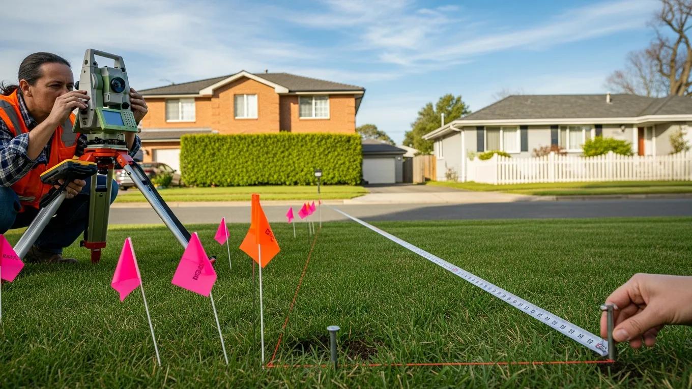
Boundary surveys establish the legal lines of a parcel through research and on-site measurement. They’re the baseline for ownership, land transfers, and dispute resolution. A proper boundary survey includes title research, monument setting or recovery, and a recordable boundary map so you have clear, defensible documentation of where your property begins and ends.
Topographic Surveys

Topographic surveys capture contours, elevations, and physical features across a site. That data informs grading, drainage, road alignment, and landscape decisions. For projects with earthwork or sensitive natural features, a detailed topo helps designers avoid costly on-site changes and ensures the design fits the land.
Construction Surveys
Construction surveys translate plans into real-world control points. Surveyors lay out building corners, foundation lines, curb locations, and other references to keep construction true to the design. Regular stake checks and as-built surveys also help track progress and prevent rework.
ALTA/NSPS Land Title Surveys
ALTA/NSPS surveys follow a strict checklist used by lenders and title companies. They document boundaries, easements, rights-of-way, and significant encroachments—information that protects buyers and lenders in commercial deals by clarifying title risks before closing.
Civil Site Plans and Subdivision Surveys
These services support land development by creating legal plats, lot lines, and engineered site plans required for municipal approval. They coordinate design constraints, setbacks, and utility placements so projects meet local ordinances and move smoothly through permitting.
UAV Aerial Surveying
Drones speed up mapping for large sites, steep terrain, and remote areas, capturing high-resolution images and point clouds that feed into models and orthophotos. For many projects, UAV surveys cut field time and cost while delivering rich data for planning and monitoring.
FHA Foundation Inspections
FHA foundation inspections assess footing and foundation conditions to confirm compliance with federal housing standards. Early inspections can prevent delays in financing and ensure the structural elements meet lender and code expectations.
Benefits for Clients:
Hiring a professional surveyor delivers several practical advantages:
- Accuracy and Precision: Licensed surveyors use proven methods and calibrated tools for reliable measurements.
- Comprehensive Solutions: From boundary research to construction stakeout, surveyors provide end-to-end services.
- Local Expertise: Familiarity with Utah codes, terrain, and permitting accelerates approvals and reduces surprises.
- Clear Communication: Professional deliverables and coordination help align owners, contractors, and agencies.
- Risk Management: Early detection of issues—easements, encroachments, or grade conflicts—saves time and money downstream.
For dependable land surveying across Utah, Ludlow Engineering offers tailored services for property owners, developers, and builders.
Coverage Areas:
Ludlow Engineering serves communities across Utah, including central regions and surrounding counties. Their statewide reach ensures local knowledge and timely support, whether you’re working in a city center, a suburban subdivision, or a remote parcel.
What Are the Key Types of Land Surveys Offered Across Utah?
To summarize, surveyors in Utah commonly provide these core services:
- Boundary Surveys
- Topographic Surveys
- Construction Surveys
- ALTA/NSPS Land Title Surveys
- Civil Site Plans and Subdivision Surveys
- UAV Aerial Surveying
- FHA Foundation Inspections
Knowing which survey fits your project keeps designs accurate and regulatory reviews smoother.
How Do Property Boundary Surveys Define Your Land Ownership?
Boundary surveys define property lines through deed research, historical records, and field measurement. The final survey provides a legal description and a map you can rely on for sales, development, fencing, or resolving neighbor disputes—so you know exactly what you own.
What Is Included in Topographic Surveying Services in Utah?
Topographic survey deliverables typically include:
- Contours: Lines showing elevation changes across the site.
- Digital Terrain Models: 3D surface models used for grading and volume calculations.
- Utility Layouts: Locations of existing utilities and visible infrastructure.
These components guide design decisions and reduce unforeseen site issues during construction.
How Does Construction Staking Support Utah Building Projects?
Construction staking turns design intent into on-site layout. Surveyors set control points and stakes that guide excavation, foundations, utilities, and final placement—keeping work aligned with plans and minimizing costly adjustments.
What Are the Benefits of Accurate Construction Layout Services?
Accurate layout brings clear advantages:
- Precision and Compliance: Structures are positioned to meet design and local code requirements.
- Error Reduction: Less rework and fewer costly mistakes during construction.
- Improved Efficiency: Contractors work with reliable reference points, keeping projects on schedule.
Good surveying saves money and time across the build lifecycle.
Which Equipment and Technology Are Used in Utah Construction Staking?
Modern construction staking relies on:
- Robotic Total Stations: High-precision instruments that automate measurements and layout.
- GNSS/GPS Systems: Satellite-based positioning for efficient control and site-wide accuracy.
- UAVs and LiDAR: Drones with LiDAR capture dense point clouds for detailed terrain models and site checks.
Combined, these tools reduce field time and improve data quality for project teams.
Automated Stakeout Surveys for Construction Efficiency
This research describes a field-tested automated stakeout system using a Leica robotic total station paired with an economical custom rover. The approach lowers barriers to real-time data capture on active sites, improving safety and efficiency. By linking physical stakeout with digital models, the system supports practical Digital Twin workflows for earthwork and construction control.
Automated Stakeout Survey for Efficient Earthwork Construction Project Control, M Lu, 2024
These innovations help survey teams deliver timely, safe, and repeatable results on construction projects.
What Are the Costs and Timeframes for Land Surveying Services in Utah?
Below are typical cost ranges and expected turnaround times for common surveys in Utah. Prices vary with property size, terrain, accessibility, and project complexity.
Use these figures as planning estimates—your surveyor can provide a detailed quote based on site conditions and deliverables.
How Much Does a Property Boundary Survey Cost in Utah?
Most residential boundary surveys in Utah fall between $500 and $3,000. Factors that influence price include acreage, terrain difficulty, legal research needs, and whether monuments must be set or recovered.
How Long Do Different Types of Land Surveys Typically Take?
Typical completion windows are:
- Boundary Surveys: 1-2 weeks
- Topographic Surveys: 2-4 weeks
- Construction Surveys: 1-3 weeks
- ALTA/NSPS Land Title Surveys: 2-4 weeks
- Civil Site Plans and Subdivision Surveys: 2-3 weeks
These timeframes depend on permitting cycles, weather, and access—your surveyor can provide a project-specific schedule.
What Regulations and Licensing Govern Land Surveying in Utah?
Utah regulates surveying to protect property rights and public safety. Licensed surveyors must follow state standards and ethical rules. These regulations ensure surveys meet legal requirements and are suitable for recording and permitting.
Which Professional Licenses Are Required for Utah Land Surveyors?
To practice legally, Utah surveyors typically must meet these requirements:
- Education: A degree in surveying, geomatics, civil engineering, or a related discipline.
- Work Experience: Supervised field and office experience under a licensed surveyor.
- Examinations: Successful completion of state and national licensing exams.
These criteria help ensure surveyors have the knowledge and judgment required for reliable work.
How Do Utah Land Surveying Regulations Affect Property Owners?
Regulations protect property owners by ensuring surveys are performed by qualified professionals and that results are defensible in legal and permitting contexts. Hiring a licensed surveyor reduces risk and makes transactions and projects more predictable.
How Is Technology Advancing Land Surveying Services in Utah?
Technology is increasing survey accuracy and cutting turnaround times. Notable advances include:
- GNSS and Total Stations: Improve positional accuracy and workflow efficiency.
- Drones and LiDAR: Enable rapid mapping of large or complex sites.
- Software Innovations: Better tools for processing, modeling, and sharing spatial data.
As instruments and software improve, surveyors can balance precision, time, and cost more effectively for each project.
Advanced Surveying Tools: Accuracy, Time & Cost
Recent studies show that advanced surveying instruments deliver gains in accuracy and productivity, but their performance depends on device specifications and site conditions. Evaluating tools by precision, time savings, and cost helps teams choose the right approach for each project.
Operational Efficiency of Advanced Surveying Tools: A Case Study, SV Shah, 2025
When chosen and applied correctly, these technologies raise the quality and usefulness of survey deliverables.
What Role Do Drones and GIS Mapping Play in Modern Surveys?
Drones collect aerial imagery and elevation data quickly; GIS organizes that information for analysis and visualization. Together they give project teams a clearer spatial picture—useful for planning, permitting, and monitoring progress over time.
How Does GPS Equipment Improve Survey Accuracy and Efficiency?
GPS and GNSS systems, especially with RTK corrections, enable centimeter-level positioning that’s essential for precise layouts and control networks. These systems speed field work and reduce the need for repeated checks, improving both accuracy and productivity.
For experienced, reliable land surveying services in Utah, contact Ludlow Engineering to discuss your project needs.
Frequently Asked Questions
What should I consider when choosing a land surveying service in Utah?
Look for a licensed surveyor with relevant local experience, a clear scope of work, and up-to-date equipment. Ask for references, sample deliverables, and a written estimate that outlines timeline, fees, and responsibilities. Confirm they carry professional liability insurance and understand local permitting requirements.
How can I prepare for a land survey on my property?
Gather deeds, prior surveys, and title reports if you have them. Clear access routes and mark any known property corners. Let neighbors know if the surveyors will be working near shared lines. Being available to answer questions on-site helps the crew work efficiently.
What are the common challenges faced during land surveying in Utah?
Surveyors often contend with steep or rugged terrain, seasonal weather, and restricted access to remote parcels. Dense vegetation and older, missing monuments can also complicate work. Experienced surveyors plan for these issues and communicate realistic schedules and costs.
How do land surveys impact property development projects?
Surveys provide the baseline data for site design, permitting, and construction. Accurate surveys prevent boundary disputes, reduce redesign, and help projects meet zoning and building requirements—keeping development on time and on budget.
What is the difference between a boundary survey and a topographic survey?
A boundary survey determines the legal property lines. A topographic survey maps the physical features and elevation of the land. Projects often require both: the boundary to establish limits, and the topo to inform design and grading.
Can I conduct a land survey myself, or should I hire a professional?
While you can take basic measurements, a licensed surveyor brings legal authority, technical training, and quality control. Hiring a professional reduces the chance of mistakes that can cause disputes or permit issues—making it the safer, more reliable choice for most projects.
What advancements in technology are shaping the future of land surveying?
Key trends include widespread UAV/LiDAR use for rapid mapping, improved GNSS accuracy with RTK and network corrections, robotic total stations that automate field work, and cloud-based software for faster processing and collaboration. These tools increase precision while lowering field time and overall project cost.
Conclusion
Professional land surveying in Utah brings clarity to ownership, certainty to design, and control to construction. By pairing local knowledge with modern technology, licensed surveyors help clients manage risk, meet regulations, and keep projects on track. To explore custom surveying solutions for your property or development, reach out to Ludlow Engineering and discuss the scope and schedule for your next project.