

Expert Land Surveyors in American Fork Utah: Trusted Survey Services for Accurate Property Solutions
Land surveying in American Fork, Utah, establishes the factual basis for property rights, development decisions, and construction accuracy by measuring and mapping land features with precision. This article explains how professional land surveyors perform boundary surveys, ALTA/NSPS surveys, topographic mapping, construction staking, and UAV aerial surveying to deliver reliable plats, legal descriptions, and control points that support transactions and projects. Property owners, developers, and contractors will learn how surveys prevent disputes, inform site planning, influence costs, and meet lender or title insurance requirements. Common pain points—uncertain property lines, permit delays, and construction rework—are addressed through clear explanations of survey types, the technologies used, and practical steps to request an accurate estimate. The guide maps the full process: an overview of services, a transparent look at costs and price drivers, reasons to choose Ludlow Engineers and Associates for local expertise, how surveys support development and legal clarity, the modern tools surveyors use, and a step-by-step path to request trusted surveying services in American Fork. Throughout, keywords like land surveyor american fork, American Fork boundary survey, and ALTA/NSPS survey American Fork are used to align practical guidance with local search intent.
What Services Do Expert Land Surveyors Provide in American Fork Utah?
Land surveyors provide a spectrum of services that define property limits, map terrain, and translate designs into physical site references; these services combine field measurements, records research, and mapped deliverables to reduce legal risk and guide construction. Typical service types include boundary surveys to establish lines, ALTA/NSPS surveys for commercial closings, topographic surveys for site design, and construction staking to locate improvements on the ground. These services produce tangible deliverables—survey plats, legal descriptions, control points, and reports—that support title insurance, permitting, and construction. Below is a concise list of the primary services most relevant to American Fork property owners and developers.
- Boundary surveys: Establish legal property lines and monument existing corners.
- ALTA/NSPS surveys: Comprehensive commercial surveys for title and lending.
- Topographic surveys: Elevation data and feature mapping for design and grading.
- Construction staking: Layout of building corners, utilities, and grades on site.
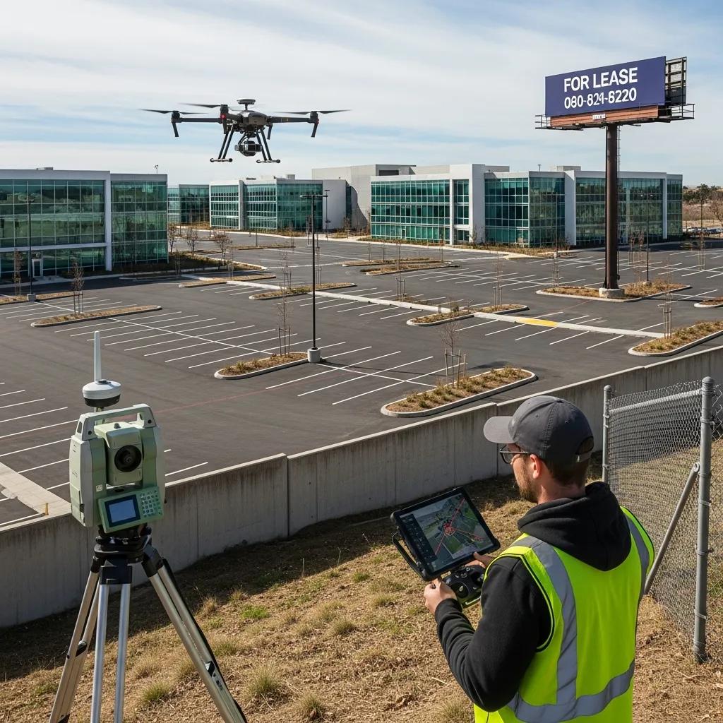
- UAV aerial surveying: Rapid site mapping and orthomosaic imagery for large parcels.
- FHA foundation inspections & civil site plans: Targeted reports supporting permits and financing.
These deliverables enable property transactions, site planning, and dispute resolution by converting measurements into authoritative documentation and legal exhibits. For readers seeking a provider whose service mix maps directly to these needs, Ludlow Engineers and Associates offers matching surveying and civil engineering services; see the dedicated trust section below for company-specific credentials and what to expect when engaging them. The next section addresses how much these services typically cost and why pricing varies.
How Are Boundary Surveys Conducted to Define Property Lines?
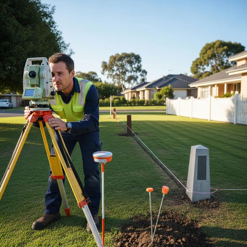
A boundary survey begins with records research to gather deeds, plats, and recorded monuments, then proceeds to fieldwork where surveyors measure existing control points and locate physical evidence of corners. Survey instruments capture horizontal and vertical positions and are reconciled against record information to prepare a survey plat and updated legal description. Professional boundary work resolves discrepancies by applying surveying law, monument evidence, and historical documentation, producing a defensible result suitable for title work or dispute resolution. Understanding the research-first approach clarifies why boundary surveys often take additional time when historical records are complex, and that meticulous documentation is the primary deliverable used in negotiations or legal proceedings.
What Is an ALTA Survey and When Is It Required?
An ALTA/NSPS survey is a standardized, comprehensive commercial survey that documents boundaries, easements, improvements, access, and other elements required by title companies and lenders to underwrite commercial transactions. This survey follows the ALTA/NSPS minimum standards and often includes additional items such as zoning, utilities, and recorded easements, making it substantially more detailed than a basic boundary survey. Lenders, title insurers, and commercial buyers typically request ALTA surveys during property due diligence to identify title risks and ensure accurate legal descriptions for closing. Because ALTA surveys compile multiple data layers and sometimes require coordination with title companies, they tend to be more complex and can carry higher costs than simpler survey types.
How Much Does a Land Survey Cost in American Fork Utah?
A short direct answer: survey costs in American Fork vary by survey type and property complexity, with typical ranges from a few hundred dollars for simple residential boundary checks to several thousand dollars for an ALTA/NSPS or extensive topographic mapping; the final price depends on parcel size, terrain, record complexity, and required deliverables.
Below is a quick-reference table showing typical cost ranges for common survey types and their key cost drivers to help homeowners and developers estimate budget needs.
Different survey types have characteristic price ranges driven by field time, data processing, and reporting requirements.
These ranges illustrate how the same property can produce different estimates depending on requested accuracy, report detail, and local conditions. Major cost drivers include the extent of records research, terrain difficulty, travel/time on site, required deliverables (e.g., signed plats, legal descriptions), and whether aerial data capture or LiDAR processing is needed. After understanding these drivers, readers often ask how to get an accurate estimate tailored to their parcel; the next subsection explains local factors in American Fork that influence pricing.
What Factors Influence Land Survey Pricing Locally?
Local factors in American Fork that influence survey pricing include terrain and vegetation which increase field time, access to historical county records that may be scattered or incomplete, parcel configuration (irregular shapes or split parcels), and proximity to established control and benchmarks. Seasonal weather and ground conditions can extend field days, while steep slopes or dense brush require additional safety measures and slower point capture. Urban parcels with heavy improvements or multiple encumbrances typically need more research and mapping, increasing cost relative to undeveloped rural lots. Preparing clear access and supplying available documents (deeds, previous plats) can reduce research time and lower overall cost by streamlining the surveyor’s workflow.
How to Get an Accurate Survey Cost Estimate from Ludlow Engineers?
To request an accurate estimate from Ludlow Engineers and Associates, provide basic parcel information, the intended use of the survey (transaction, site design, permitting), and any existing documents such as deeds or prior plats; these inputs allow the firm to scope fieldwork, research time, and deliverables. Ludlow Engineers typically follows a process of records review, preliminary scope confirmation, and a site visit when necessary to produce a formal estimate and timeline tailored to the client’s goals. Expect a clear written estimate that outlines assumptions, deliverables (plat, legal description, digital files), and anticipated turnaround once scope is agreed. If you are preparing a request, include the property address, parcel ID if known, and the desired survey type to accelerate the quoting process; the firm’s local experience helps translate those details into a realistic cost and schedule.
Expert Land Surveying Services in American Fork, Utah
Choosing a qualified provider matters because experience, licensing, and local knowledge directly impact accuracy, regulatory compliance, and project timelines; Ludlow Engineers and Associates positions itself as a civil engineering and surveying firm that matches common client needs in Utah. The firm’s service set aligns with the core survey types discussed earlier—boundary surveys, ALTA/NSPS surveys, topographic mapping, construction staking, UAV aerial surveying, and FHA foundation inspections—so clients can access integrated engineering support alongside surveying. Below is a concise attributes table that clarifies what Ludlow Engineers emphasizes and how it benefits property owners and developers.
Ludlow Engineers and Associates is referenced in regional resources and blog posts that mention team members by name, and the firm’s local presence supports practical advantages during permitting and title discussions. The next subsection highlights specific capabilities and experience that inform their approach to projects.
What Experience and Expertise Do Ludlow Engineers Bring?
Ludlow Engineers and Associates operates as a civil engineering firm with surveying capabilities and provides the suite of services needed for property due diligence, site development, and construction support; local resources note longstanding operations in Utah and a team experienced in property surveys and civil plans. The firm’s project work typically includes boundary and ALTA surveys, topographic mapping, civil site plans, and construction staking—services that rely on licensed surveyors and engineers to produce signed, usable deliverables. This combination of surveying and engineering helps clients move from measurement to design more efficiently, reducing the need to coordinate multiple vendors and streamlining communication across project phases. Readers seeking a single point of responsibility for both survey control and site design will find this integrated capability particularly useful.
How Does Local Knowledge Benefit Your Surveying Project?
Local knowledge shortens lead times and reduces errors because experienced practitioners understand county record idiosyncrasies, typical easement patterns, and local permit workflows that affect survey scope and approvals. Familiarity with American Fork terrain and common infrastructure layouts allows surveyors to anticipate access issues and efficiently plan fieldwork, which cuts unnecessary site visits and expedites deliverables. Local relationships with municipal or county staff can help clarify submittal expectations and avoid rework that delays permitting or closings. Applying this local expertise during the research and field phases translates into more predictable schedules and fewer surprises for clients moving into design, construction, or transaction stages.
How Do Land Surveys Support Property Development and Legal Clarity in American Fork?
Land surveys provide the empirical foundation for property development by verifying boundaries, documenting easements, identifying encroachments, and supplying topographic data essential for planning, grading, and drainage design. Developers and homeowners rely on survey plats and legal descriptions to secure permits, obtain title insurance, and set construction limits; without accurate surveys, projects risk costly rework or legal disputes. Surveys also create the control framework for civil engineering plans, ensuring that grading, utilities, and foundations are positioned relative to true property lines and existing site features. Knowing how surveys fit into the overall development lifecycle helps stakeholders schedule surveys at the right time to avoid delays and ensure regulatory compliance.
How Do Surveys Prevent Property Line Disputes and Easement Issues?
Accurate surveys mitigate disputes by producing documented evidence—survey plats, monuments, and legal descriptions—that clarify where ownership and easement rights exist, allowing neighbors and parties to negotiate from an objective basis. When encroachments or ambiguous boundaries arise, a professional survey establishes the recorded facts and supports legal resolution or boundary agreements. Surveyors also identify existing easements and rights-of-way on plats, which informs buyers and developers about limitations before construction or sale. Using certified deliverables in negotiations or legal filings reduces uncertainty and often prevents escalation to costly litigation.
What Role Do Surveys Play in Construction Staking and Site Planning?
Construction staking translates engineered plans into physical markers on the site, locating foundation corners, curb lines, and utility alignments so contractors can build to design intent with minimal rework. Topographic surveys provide the elevation and feature data engineers use to develop grading plans and stormwater solutions, reducing the risk of drainage problems or permit denials. Regular staking and as-built surveys during construction confirm that work follows plans and help catch deviations early when corrections are less expensive. Together, topo mapping and staking protect project budgets by aligning field execution with approved designs and by documenting compliance for inspections and certifications.
What Are the Latest Technologies Used by Land Surveyors in American Fork Utah?
Modern land surveying leverages GNSS/GPS, robotic total stations, LiDAR scanning, and UAV aerial surveying to capture spatial data faster and with higher resolution than traditional methods. Each technology measures different aspects—GNSS provides broad control coordinates, total stations deliver precise point measurements, LiDAR captures dense point clouds for 3D models, and UAVs produce orthomosaics and DSMs for large-area mapping. The following table compares these technologies and clarifies the benefits clients receive when firms apply the right tool to the task.
Indeed, the evolution of surveying tools has significantly enhanced the precision and efficiency of land measurement, directly impacting project timelines and budgets.
Advanced Surveying Tools: Accuracy, Time, and Cost Efficiency
Today, with advanced surveying instruments, surveying has become easier and more powerful. Accuracy is a prime concern concerning the time and cost involved in surveying. The advanced surveying instruments perform differently in different locations depending on their specifications and functions, pertaining to time and cost. Hence, it is necessary to determine the performance of these instruments with respect to precision, time, and cost.
Operational Efficiency of Advanced Surveying Tools: A Case Study, SV Shah, 2025
Choosing the appropriate technology depends on project goals: GNSS for broad control, total stations for legal boundaries, LiDAR for dense 3D models, and UAVs for rapid mapping. Local regulatory considerations for UAV operations and required accuracy thresholds for ALTA or boundary surveys inform tool selection and workflow planning.
How Does UAV Aerial Surveying Improve Accuracy and Efficiency?
UAV aerial surveying collects high-resolution imagery and elevation models that accelerate topographic mapping and provide orthomosaics useful for initial site evaluation and massing studies. For large or hard-to-access properties, drones reduce field time, lower safety risk, and produce deliverables like digital surface models and orthophotos that integrate with CAD and GIS workflows. While UAV data complements ground control and field measurements, combining drone outputs with GNSS control and total station checks ensures accuracy suitable for engineering and mapping. As a result, clients receive quicker site overviews and actionable data that shorten design timelines and improve decision-making.
This approach aligns with modern research highlighting the efficiency and detail offered by drone-based methods.
UAS Photogrammetry for High-Resolution Topographic Surveying
Highly detailed topographic surveying at minimal cost and effort has always been one of the developing areas of scientific interest. Image-based remote sensing solutions using unmanned aerial systems (UAS) and structure from motion (SfM) with multi-view stereo (MVS) photogrammetry are the latest automation and advancement in surveying engineering that provides high-resolution topographic data.
Accuracy of unmanned aerial systems photogrammetry and structure from motion in surveying and mapping: a review, SI Deliry, 2021
What Advanced Equipment Is Used for Topographic and ALTA Surveys?
Topographic and ALTA surveys commonly employ a mix of total stations for precise point measurements, GNSS receivers for establishing control, and laser scanners or UAVs where dense surface data is required. Total stations are ideal for capturing visible monuments, improvements, and legal evidence with millimeter-level precision, while GNSS supports rapid control for larger projects. LiDAR and laser scanning produce detailed models of terrain and structures, reducing manual point collection and improving contour accuracy for grading and drainage design. Selecting the right combination of instruments ensures deliverables meet required accuracy standards and client expectations.
How Can Property Owners Request Trusted Land Survey Services in American Fork?
Requesting a survey begins with clarifying the purpose—sale, development, or construction—and assembling basic property information so a provider can scope work accurately; clear initial communication reduces misunderstandings and produces a timely estimate. The process typically involves an initial inquiry with parcel details, a records review to identify requirements, a scoped site visit if needed, and delivery of a written proposal that outlines deliverables, schedule, and assumptions. Below is a step-by-step checklist to help property owners prepare for a quote and understand what to expect from first contact through project completion.
- Provide property identifiers: Include address, parcel number, or deed reference if available.
- State the survey purpose: Indicate whether the work is for a sale, design, permitting, or financing.
- Attach existing documents: Share deeds, prior plats, or title commitments to speed research.
- Describe access and site conditions: Note locked gates, vegetation, or steep terrain that affect fieldwork.
Supplying these items helps the surveyor produce a focused proposal, and presenting clear goals at the outset improves the accuracy of the estimate and timeline. The next subsection explains the specific quote process used by Ludlow Engineers and Associates.
What Is the Process to Request a Quote from Ludlow Engineers?
When contacting Ludlow Engineers and Associates for a quote, provide the property identifiers, the intended use of the survey, and any supporting documentation; this enables the firm to perform a preliminary records review and advise on the appropriate survey type. After the initial intake, Ludlow Engineers typically confirms scope details, schedules a site visit if necessary, and issues a written estimate that lists deliverables (plat, legal description, digital files), assumptions, and an expected timeline. Response times vary with complexity, but clients can expect a clear proposal that outlines next steps and any additional approvals or title company coordination required. Including clear goals and accessible documents up front accelerates the process and helps align expectations.
What Should Clients Expect During the Surveying Process?
Clients should expect a defined timeline that begins with records research, followed by field data collection, draft deliverable review, and final signed plat or report delivery; the surveyor will coordinate access and notify neighbors when necessary for fieldwork. On-site activities may include monument recovery, control setup, and point collection using GNSS or total station instruments, while UAV flights or LiDAR scans may be scheduled for topographic data capture. Draft deliverables provide an opportunity for client review and clarifications before finalization, and the final package typically includes a survey plat, legal description, and digital files suitable for permitting, title work, or construction. Clear communication throughout the process reduces surprises and ensures the final documents meet transactional, regulatory, and construction needs.
Frequently Asked Questions
What qualifications should I look for in a land surveyor in American Fork?
When selecting a land surveyor in American Fork, look for qualifications such as state licensing, experience in local surveying practices, and familiarity with the specific types of surveys you need, such as boundary or ALTA surveys. Additionally, check for professional affiliations with organizations like the National Society of Professional Surveyors (NSPS) or state surveying associations. A reputable surveyor should also have a solid portfolio of past projects and positive client testimonials, which can provide insight into their reliability and quality of work.
How long does a typical land survey take to complete?
The duration of a land survey can vary significantly based on the type of survey, the complexity of the property, and the surveyor’s workload. Generally, a simple boundary survey may take a few days to a week, while more complex surveys, such as ALTA/NSPS surveys or topographic surveys, can take several weeks. Factors that influence the timeline include the need for historical research, the size of the parcel, and weather conditions. It’s best to discuss timelines with your surveyor during the initial consultation to set realistic expectations.
What should I do if I disagree with the results of a land survey?
If you disagree with the results of a land survey, the first step is to review the survey documents and discuss your concerns with the surveyor. They can clarify their methods and findings. If discrepancies remain, you may consider hiring a second surveyor for a second opinion. In some cases, legal action may be necessary, especially if the survey impacts property boundaries or easements. Consulting with a real estate attorney can provide guidance on how to proceed based on your specific situation.
Can I perform my own land survey, or do I need a professional?
While property owners can conduct informal measurements or use tools like GPS for personal reference, a professional land survey is essential for legal and transactional purposes. Only licensed surveyors can provide official survey plats and legal descriptions that are recognized by courts and title companies. Attempting to perform your own survey may lead to inaccuracies and potential disputes, especially if property boundaries are contested. It’s advisable to hire a qualified surveyor to ensure compliance with local regulations and accuracy in documentation.
What are the common challenges faced during land surveys?
Common challenges during land surveys include access issues, such as locked gates or dense vegetation, which can hinder fieldwork. Additionally, discrepancies in historical records or unclear property boundaries can complicate the survey process. Weather conditions may also affect timelines, especially in areas with harsh climates. Surveyors must navigate these challenges while ensuring accuracy and compliance with local regulations. Effective communication with property owners about site conditions and access can help mitigate these issues and streamline the surveying process.
How can I prepare my property for a land survey?
To prepare your property for a land survey, start by ensuring clear access to the site. Remove any obstacles like vehicles, debris, or overgrown vegetation that may impede the surveyor’s work. Gather relevant documents, such as previous surveys, deeds, or property descriptions, and provide them to the surveyor to facilitate their research. Inform neighbors about the survey, especially if it involves boundary lines, to prevent misunderstandings. Clear communication and preparation can help the surveyor complete their work efficiently and accurately. You should consider boundary survey services for precise measurement.