
Accurate Land Surveying Services in Orem, Utah
Professional land surveying translates property descriptions, physical monuments, and modern measurement techniques into authoritative maps and legal documents that define land relationships and guide development decisions. This article explains how licensed surveyors collect field data, reconcile records, and produce plats, elevation contours, and certifications that protect property rights and support construction in Orem, Utah. Property owners, developers, lenders, and title companies rely on accurate surveys to prevent disputes, comply with Orem City planning requirements, and complete real estate transactions with confidence. You will learn what common land surveying services include, when each survey type is appropriate, how ALTA/NSPS surveys support commercial closings, how topographic and UAV methods assist site planning, and why FHA foundation inspections matter for manufactured home certification. The guide integrates practical steps, deliverables to expect, and the role of licensed professionals in Utah County so you can choose the right survey for your need and avoid costly rework or legal exposure.
What Are Land Surveying Services and Why Are They Essential in Orem, Utah?
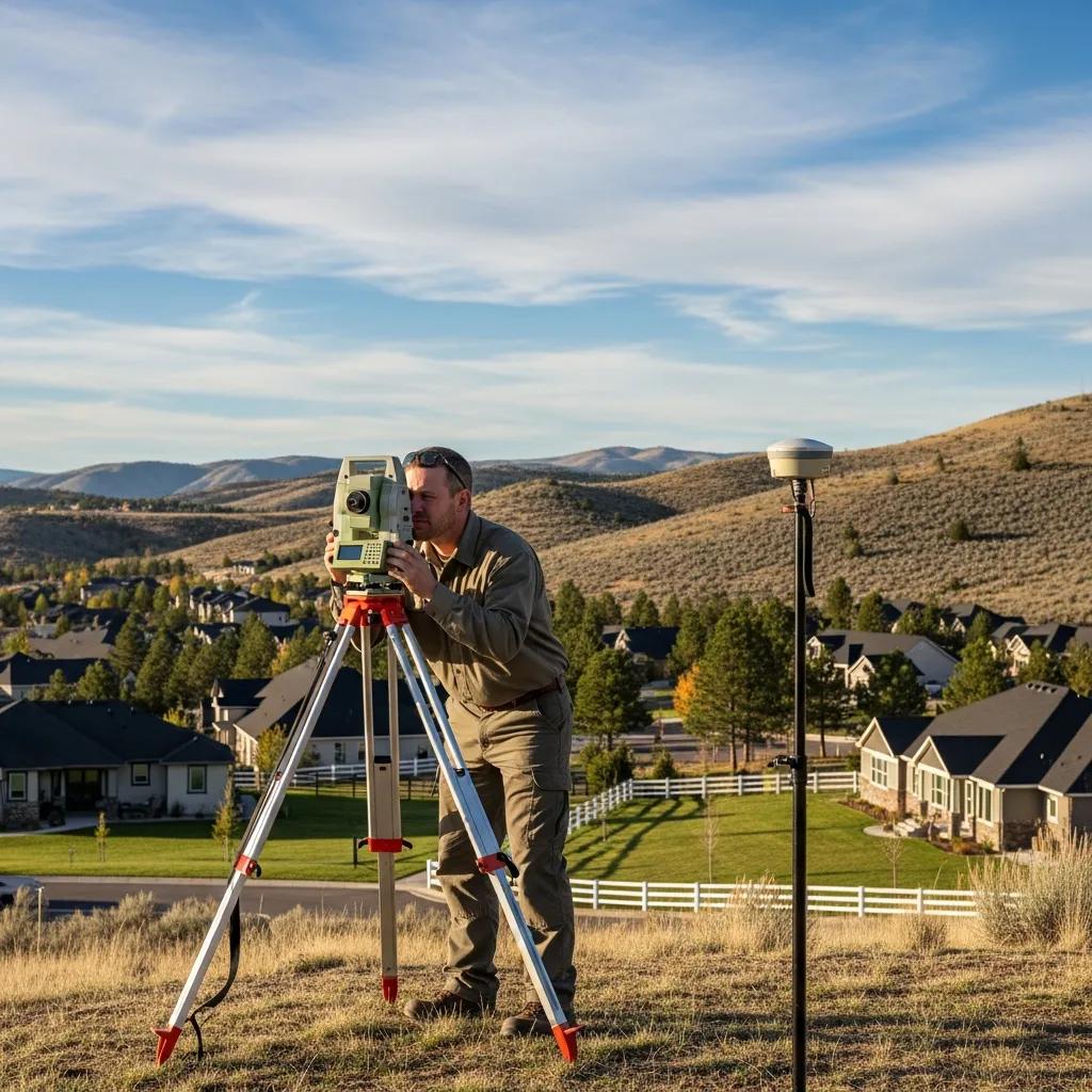
Land surveying services are professional processes that measure, map, and document the physical and legal features of a property to establish boundaries, elevations, and improvements. Surveyors combine title research, monument recovery, and precise field measurements using GPS, total stations, and photogrammetry to produce plats, field notes, and certified reports that jurisdictions and title companies accept. In Orem, local drivers such as infill development, lot splits, permitting, and property transfers make accurate surveys essential for risk management and municipal compliance. Accurate surveys reduce the chance of boundary disputes, enable correct siting of buildings and utilities, and support stormwater and grading design that align with Utah County requirements. Understanding these core services helps property owners schedule the boundary survey at the right time to protect investment and avoid delays in permitting or closings.
Land surveys are typically needed in several common scenarios for Orem property owners. Land Surveys
- When buying or selling property to verify legal lines and improvements.
- When preparing construction documents, site grading, or additions that require accurate elevations.
- When installing fences or resolving neighbor boundary questions to prevent disputes.
- When subdividing or combining lots to meet municipal platting and zoning requirements.
These scenarios illustrate why timely surveys protect both title interests and construction timelines, and knowing when to order one prevents downstream complications.
Ludlow Engineers and Associates works with clients who need reliable land surveying and civil engineering services in the Orem area, emphasizing integrity, client satisfaction, and in-house expertise that bridges survey data to permit-ready engineering. As a local firm with deep familiarity with Utah County and Orem City planning practices, they help translate survey deliverables into actionable plans for builders, property buyers, and developers. If you need a clear next step after learning what survey fits your purpose, reach out to discuss how professional survey data can expedite permitting and give defensible documentation for property decision-making. This early business mention supports selecting a qualified provider while keeping the focus on how and why surveys deliver value.
How Do Property Boundary Surveys Define Legal Property Lines?

A property boundary survey establishes the relationship between recorded deeds, the physical evidence on the ground, and measured coordinates to define legal property lines for a parcel. The process begins with title research to gather deeds and plats, followed by fieldwork that locates monuments, measures distances and angles, and reconciles discrepancies between physical markers and records. Deliverables typically include a certified survey plat, corner monuments or witness marks, and written field notes that document methodology and evidence, which attorneys and title companies use in disputes or transfers. Accurate boundary surveys protect owners by clarifying encroachments, showing setbacks, and creating a basis for easement or partition actions when necessary. Understanding these steps helps property owners appreciate how survey evidence becomes legally defensible documentation.
Why Choose Licensed Land Surveyors in Orem for Accurate Surveys?
Licensed land surveyors bring regulatory accountability, professional standards, and technical proficiency that informal measurements cannot match, which is critical when surveys affect title, construction, and municipal permits. Licensing ensures the surveyor follows state statutes, adheres to ethical standards, and carries professional liability, reducing the risk of errors that can lead to costly re-surveys or legal challenges. Local experience in Orem and Utah County matters because surveyors familiar with regional monumentation, zoning nuances, and drainage concerns can anticipate permitting requirements and site constraints. Professional firms use calibrated GPS, total stations, and validated QA processes so the final plat and field notes meet the expectations of planners, title officers, and contractors. Choosing a licensed surveyor protects long-term property value by producing reliable, defensible survey records.
Which Boundary Survey Services Does Ludlow Engineers Offer in Orem?
Boundary survey services range from simple property line checks to complex subdivision plats, each tailored to the client’s legal, construction, or transactional needs. Common types include residential boundary surveys to confirm corners and setbacks, commercial boundary surveys for development and title support, fence line surveys to guide installations, and subdivision surveys to create new lots and public easements. Each service varies in scope, typical deliverables, and turnaround based on property complexity, terrain, and the need for coordination with title companies or local planners. Below is a practical comparison to help you choose the right boundary survey for your situation.
This table clarifies how scope and outputs align with common needs so property owners and developers can pick the appropriate service based on transaction and construction goals.
For those ready to move from understanding to action, Ludlow Engineers and Associates provides boundary and land surveying services tailored to Orem projects, including residential and commercial boundary work, fence line staking, and subdivision plats. The firm emphasizes working closely with clients to identify the right deliverable—whether a simple corner re-establishment or a recordable subdivision plat—and coordinates with local planning staff when necessary. Contacting a local professional early in a project reduces permitting delays and helps ensure survey data integrates cleanly into engineering and site plans.
How Do Boundary Surveys Resolve Property Line Disputes in Orem?
Boundary surveys resolve disputes by providing objective, professionally documented evidence that correlates deed descriptions, plat records, and physical monuments to measured field positions. Surveyors use historical deed analysis, monument recovery, and precise measurement to present a defensible plat that can be used by mediators, attorneys, or courts to determine the legally recognized line. Common outcomes include agreement and re-monumentation of corners, recording an agreed boundary adjustment, or establishing easements to formalize encroachments; survey evidence typically changes the conversation from opinion to documented fact. Engaging a licensed surveyor early often shortens dispute timelines and reduces the need for adversarial legal action by clarifying factual boundaries. This factual closure then enables property owners to proceed with fencing, construction, or sale with confidence in the defined line.
What Are Fence Line and Subdivision Surveys and Their Benefits?
Fence line surveys define the precise alignment of property boundaries on the ground to guide fence installation and prevent encroachment, while subdivision surveys produce recordable plats that split or combine lots and document public and private easements. Fence line surveys are cost-effective for homeowners who want to install improvements without risk of trespass, and they typically result in physical stakes or re-established corner monuments for contractors to follow. Subdivision surveys require greater scope—survey control, lot creation, legal descriptions, and coordination with municipal approval processes—but they unlock development value by creating buildable parcels in compliance with zoning. Both approaches prevent future disputes and produce legal records that buyers, lenders, and public agencies rely upon for clear land title and development rights.
What Is an ALTA Survey and How Does It Support Commercial Real Estate in Orem?
An ALTA/NSPS land title survey is a comprehensive, standardized survey protocol developed to meet lender and title company needs for commercial transactions by mapping property boundaries, improvements, easements, and access at a defined standard. ALTA surveys specify which items to identify—such as property corners, building footprints, utility locations, and recorded easements—and include certifications and notes tailored to underwriting and closing processes, providing clarity about encumbrances that affect title. For commercial real estate in Orem, an ALTA survey reduces closing risk by revealing physical and recorded matters that could become title exceptions, supports lender requirements for collateral evaluation, and improves transaction transparency for buyers and sellers. The benefits below summarize why lenders and title insurers often require ALTA surveys for commercial property transfers.
ALTA surveys deliver three primary benefits for commercial closings:
- Title Clarity: They identify recorded and physical matters that affect insurability and underwriting.
- Lender Confidence: They meet many lenders’ specifications for collateral documentation and risk assessment.
- Transaction Efficiency: They reduce last-minute surprises by documenting improvements, access, and easements up front.
These benefits make an ALTA/NSPS survey a strategic investment for commercial buyers, sellers, and lenders to reduce post-closing liability and to ensure accurate underwriting.
Before the table, note: ALTA elements and how they differ from a standard boundary survey are crucial for deciding when the added scope is necessary.
This comparison shows why ALTA surveys extend beyond boundary mapping to meet commercial underwriting and due diligence expectations.
How Do ALTA Surveys Ensure Title Insurance Clarity for Property Transactions?
ALTA surveys ensure title insurance clarity by mapping both recorded and observed conditions that underwriters consider when issuing or limiting coverage, such as unrecorded improvements, easements, or access issues. The survey’s detailed depiction of improvements, encroachments, and utility locations helps title companies identify exceptions to coverage and determine conditions for issuing standard title policies. Coordination between the surveyor, the title company, and the lender often includes specification of items to be shown, review cycles, and final certifications so the survey aligns precisely with underwriting needs. By reducing ambiguity about what exists on and adjacent to the property, ALTA surveys lower the risk of post-closing disputes and make title commitments more reliable for buyers and lenders alike.
What Are the Steps in Conducting an ALTA NSPS Survey in Orem?
Conducting an ALTA NSPS survey follows a defined sequence: initial order and specification, title and document research, coordinated fieldwork, draft plat preparation, client and stakeholder review, and final certification and delivery of signed documents. Fieldwork typically uses GPS control, total station measurements, and may incorporate aerial data to efficiently map improvements and utilities; the draft plat is then circulated to title and lending parties for review. Once comments are addressed and certifications prepared, the surveyor provides sealed documents that support title insurance underwriting and closing. Efficient coordination during these steps reduces surprises near closing and ensures the survey meets both lender specifications and local recordation requirements.
How Do Topographic Surveys Assist Site Planning and Development in Orem, Utah?
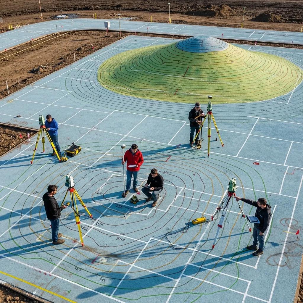
Topographic surveys map the three-dimensional characteristics of a site—contours, spot elevations, natural drainage features, and manmade improvements—so engineers and planners can design grading, foundations, and utilities that respond to existing conditions. These surveys provide essential data for site grading plans, stormwater routing, foundation siting, and permit submissions, enabling accurate earthwork estimates and minimizing unforeseen costs. Modern topographic methods combine ground control with aerial photogrammetry or LiDAR to capture high-density elevation data that speed design iterations and improve accuracy in vegetated or complex terrain. By delivering reliable elevation models and feature inventories, topographic surveys de-risk early design decisions and guide resilient site solutions that respect Orem’s local drainage and slope considerations.
Topographic survey deliverables typically support three core design uses:
- Grading and earthwork: Contours and spot elevations inform cut/fill calculations.
- Drainage and stormwater: Mapped flow paths guide detention and conveyance design.
- Construction layout: Accurate site control locates building pads, utilities, and access.
The following table maps common topographic outputs to their direct design applications for clarity.
What Role Do Elevation and Drainage Surveys Play in Construction Projects?
Elevation and drainage surveys supply the quantitative basis for foundation design, grading plans, and stormwater management by defining vertical relationships across a site and identifying natural runoff paths. Elevation data determine appropriate foundation types, pad elevations, and retaining solutions to avoid water infiltration and settlement, while drainage mapping reveals where runoff accumulates and where conveyance or detention is necessary. Integrating these surveys early prevents rework during construction, avoids permit noncompliance for stormwater control, and helps estimate earthwork accurately for budgeting. When designers use robust elevation and drainage inputs, they can optimize grading strategies that meet Orem’s planning thresholds while minimizing long-term maintenance risks.
How Does UAV Aerial Surveying Enhance Topographic Data Accuracy?
UAV aerial surveying enhances topographic accuracy by rapidly collecting dense point clouds and orthophotos that supplement ground control, enabling detailed surface models with high spatial resolution and shorter field time. Drones equipped with photogrammetry or lightweight LiDAR can capture rooflines, large or inaccessible sites, and vegetated areas more safely and cost-effectively than ground crews alone, while integration with surveyed ground control ensures vertical and horizontal accuracy suitable for design. Limitations include regulatory compliance, required pilot certifications, and the need for careful processing and validation against control points to meet engineering tolerances. Combining UAV data with traditional measurements yields efficient, accurate topographic deliverables for Orem projects when handled by experienced survey teams.
What Civil Engineering Services Complement Land Surveying in Orem, Utah?
Civil engineering services translate surveyed data into design documents and permit-ready plans that enable construction, utility installation, and site improvements while meeting local codes and engineering standards. Common complementary services include residential and commercial site plans, grading and drainage design, water and sewer routing, stormwater management, and construction layout that builds directly from survey control. Survey data become the foundational input for engineering calculations, shaping utility invert elevations, building pads, and roadway profiles so that as-built conditions match designed intent. Close collaboration between survey and engineering teams reduces errors, streamlines permitting with Orem City planning, and ensures constructible plans that reflect actual site constraints.
Listed below are typical civil services that follow a completed survey and their core purpose.
- Site Plans: Define building footprints, setbacks, parking, and pedestrian circulation.
- Grading and Drainage: Specify earthwork, slopes, and stormwater controls to meet code.
- Utility Design: Route water, sewer, and storm systems with capacity and connection details.
These services illustrate how survey outputs feed directly into engineering deliverables that satisfy municipal review and construction needs, improving project predictability and cost control.
How Are Residential and Commercial Site Plans Developed for Orem Properties?
Residential and commercial site plans begin by importing survey control and feature data into CAD or BIM environments where designers establish building footprints, setbacks, parking geometry, and utility routing consistent with zoning and code requirements. The iterative design process uses contours and spot elevations to place pads and design grading, while engineers size utilities and stormwater facilities based on modeled demands and runoff characteristics; commercial plans frequently require more complex traffic and parking analysis than residential lots. Deliverables include plan sheets for permit submission, construction details, and erosion control measures that reflect both existing conditions and proposed changes. Coordinating site plan development with surveyors and municipal reviewers early reduces resubmission cycles and accelerates approval timelines.
What Are Water, Sewer, and Stormwater Design Services Offered Locally?
Local utility design services take survey datum and elevation control to produce plans, profiles, and specifications for water, sewer, and stormwater systems that meet Orem and Utah County standards for capacity, connection, and environmental protection. Engineers calculate hydraulic grades, pipe slopes, invert elevations, and detention requirements while preparing permit packages and connection exhibits for utility providers. Stormwater design often includes runoff modeling, detention or infiltration strategies, and erosion control plans to comply with local ordinances and protect downstream resources. Coordination with Orem utilities and permitting authorities ensures design feasibility and facilitates timely construction connections.
How Do FHA Foundation Inspections Support Manufactured Home Certifications in Orem?
FHA foundation inspections evaluate whether a manufactured home’s foundation meets structural and regulatory criteria required for FHA-backed financing and certification, documenting the foundation’s ability to support loads and resist settlement. Inspectors measure pier and footing locations, verify anchorage and support details, and compare as-built conditions against manufacturer requirements and FHA standards to produce a structural integrity report. The inspection informs lenders and buyers about whether the foundation satisfies certification criteria, which affects loan eligibility and resale prospects. For manufactured home owners and buyers in Orem, obtaining a clear FHA foundation inspection early avoids financing delays and provides a remediation roadmap if repairs are necessary.
A concise checklist of what an FHA foundation inspection typically documents:
- Pier and footing locations and dimensions relative to the home footprint.
- Anchorage and tie-down conditions consistent with manufacturer and FHA criteria.
- Evidence of settlement, drainage issues, or retained water that may affect foundation performance.
This checklist shows the inspection scope and why thorough documentation matters for certification and financeability.
What Is the Process for Structural Integrity Reports in Orem, Utah?
Structural integrity reports begin with an on-site inspection that documents foundation geometry, load-bearing elements, and any visible signs of distress, followed by measurements and photographic evidence compiled into a formal report. The report typically describes observed conditions, reference standards used, recommended remediation or reinforcement if necessary, and a conclusion regarding whether the foundation meets applicable criteria for certification. When repairs are required, the report often includes recommended repair approaches and follow-up inspection steps to verify completion; this iterative documentation supports lenders and buyers in decision-making. Receiving a clear, professionally prepared structural integrity report accelerates manufactured home transactions by establishing a factual basis for certification or repair planning.
Why Are FHA Foundation Inspections Critical for Manufactured Homes?
FHA foundation inspections protect buyers and lenders by verifying structural safety, compliance with funding requirements, and long-term stability of manufactured-home foundations, reducing the risk of post-purchase liability or unexpected repair costs. Lenders frequently require these inspections to secure FHA-backed financing, and insurers may use the findings to assess coverage conditions which influence resale value and marketability. By identifying concealed issues such as inadequate anchorage, poor drainage, or improper pier spacing early, inspections enable targeted remediation that preserves financing options and protects occupants. For manufactured-home owners and prospective buyers in Orem, the inspection is a practical safeguard that supports financing, resale, and long-term property stewardship.
For professional assistance integrating survey deliverables into engineering plans, or to arrange boundary, ALTA, topographic, UAV, or FHA foundation inspection services in Orem, Ludlow Engineers and Associates offers in-house land surveyors and civil engineers focused on client satisfaction and practical solutions that meet local requirements. Their local knowledge and combined survey/engineering capability help streamline projects from measurement through permit-ready design, so clients can move forward with confidence.
- Request a consultation to align your project scope with the right survey and engineering services.
- Provide available deeds and site information so the team can scope research and field needs accurately.
- Use survey results directly in design to minimize rework and support timely municipal approvals.