As the world of construction evolves, so do the methods we use to map out our future projects. This blog explores the innovative techniques in land surveying that are not only changing the game but paving the way for more efficient, accurate, and environmentally friendly construction projects.

The Importance of Land Surveying in Construction
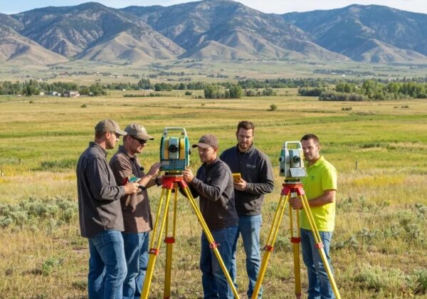
Land surveying plays a pivotal role in the construction industry, laying the groundwork for every development project. This process is essential for accurately mapping and measuring land before any construction begins. It helps avoid costly mistakes and legal disputes by ensuring that every structure is built on the right piece of land and complies with zoning and project specifications. With the introduction of new technologies, the field of land surveying is witnessing a shift towards more sustainable and efficient practices. As outlined by Ludlow Engineers, understanding boundary surveys is crucial whether you’re planning a new development or making significant changes to your property (Ludlow Engineers).
Accuracy in land surveying is paramount, reducing the margin for error and ultimately saving time and resources throughout the construction process. Advanced surveying technologies have enhanced the precision of these measurements, enabling construction projects to proceed with confidence. The use of drones, 3D laser scanning, and GPS has revolutionized traditional methods, making surveys faster, more accurate, and less labor-intensive. This progress has made a substantial impact on the way properties are assessed, plotted, and developed. Through precise land surveying, we can now execute complex projects with remarkable precision, supporting sustainable development practices (Ludlow Engineers).
Enter the Drones: Aerial Surveying Takes Off
Drones have taken land surveying to new heights, offering a bird’s-eye view that’s invaluable for mapping large areas with accuracy and speed. These unmanned aerial vehicles (UAVs) can navigate tough terrains and capture high-resolution images that are used to create detailed maps and models. Besides their efficiency, drones are a more eco-friendly option for land surveying, minimizing the human footprint on sensitive lands. The Benefits of Drone Topographic Surveys show how this technology is revolutionizing land surveying by providing accurate, detailed data in a fraction of the time it used to take (Ludlow Engineers).
3D Laser Scanning: Capturing Every Detail
3D laser scanning is another game-changer in land surveying, offering the ability to capture detailed measurements of complicated structures and terrains. This technology creates highly accurate 3D models of surveyed areas, allowing for better planning and analysis in the early stages of construction projects. 3D laser scanning is particularly useful in the renovation of existing structures, as it can accurately document and model complex environments. The precision it offers is critical for ensuring that new modifications will fit perfectly with the already established structures, further emphasizing the role of advanced technology in creating sustainable and efficient development strategies (Ludlow Engineers).
GPS and GNSS Systems: Precision from the Satellites
Global Positioning System (GPS) and Global Navigation Satellite Systems (GNSS) have vastly improved the accuracy of land surveys. By utilizing satellite technology, surveyors can determine exact positions with unprecedented precision. This accuracy is crucial for large-scale and complex projects where the slightest miscalculation can lead to significant issues. GPS systems are particularly effective for mapping vast stretches of land, as they can cover more ground in less time than traditional methods. The introduction of these satellite systems represents a leap forward in our ability to plan and execute construction projects with precision, ensuring that every development is positioned accurately and according to plan.
The Role of Robotics in Modern Land Surveying
The integration of robotics into land surveying signifies a shift towards more autonomous survey processes. Robotic total stations, for example, allow a single surveyor to control the instrument from a distance, thereby increasing efficiency and safety on site. These self-operating machines can collect data with minimal human intervention, streamlining the surveying process while reducing the potential for human error. The evolution of robotics in surveying not only enhances precision but also opens up new possibilities for how we map and understand our world. As these technologies continue to develop, they will undoubtedly play a larger role in reshaping the landscape of land surveying and construction.
Sustainable Surveying: Balancing Accuracy and Ecology
As the global emphasis on sustainability grows, so does the push for eco-friendly land surveying practices. Sustainable surveying takes into account the environmental impact of surveying activities, promoting techniques that minimize ecological disruption. This approach can include the use of drones to reduce land disturbance or leveraging digital tools to decrease the need for physical markers and stakes. Sustainable surveying practices not only support the health of our planet but also align with the construction industry’s overall shift towards more environmentally responsible development projects. By incorporating sustainable methods, land surveyors can contribute to conservation efforts while ensuring the accuracy and reliability of their work.
Conclusion: The Future Is Now
The advancements in land surveying technology and methodologies have revolutionized the construction industry. From drone surveying to 3D laser scanning, the new wave of land surveying techniques offers unprecedented precision and efficiency. As we continue to embrace these innovations, the future of construction looks brighter, with the promise of projects that are better planned, better built, and better for our planet. Explore more about our cutting-edge services and how we can assist your next project by visiting Ludlow Engineers.