Spanish Fork Land Surveyors — Trusted Boundary, ALTA, and Property Surveys
Ludlow Engineers and Associates delivers precise, local land surveying services in Spanish Fork, Utah — from boundary and ALTA/NSPS surveys to topographic and property line work for residential, commercial, and development projects. This page outlines the core survey types, typical costs and what drives them, complementary civil engineering and inspection services, and straightforward steps to begin a project in Spanish Fork. Property owners, buyers, developers, and lenders will find clear guidance on which survey fits their needs, what to expect in the deliverables, and how local terrain and title research affect price and timing. You’ll also learn how combined survey + engineering workflows can smooth permitting and closings. Below we cover why to choose a local Spanish Fork surveyor, the main survey types and outputs, transparent cost factors with sample ranges, related engineering and FHA inspection offerings, common questions about timing and necessity, and how to start a project with Ludlow Engineers and Associates.
Why Choose Our Land Surveying Services in Spanish Fork Utah?
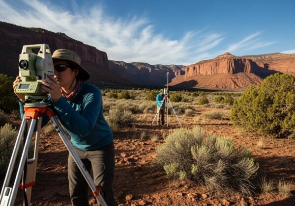
Working with a local surveying firm means area knowledge, faster turnaround, and smoother coordination with county permitting and title professionals. At Ludlow Engineers and Associates we pair those advantages with in-house licensed surveyors and engineers. Local experience helps us anticipate access and terrain issues common in Spanish Fork and Utah County, reducing surprises in the field and speeding document delivery for closings and permits. We focus on clear communication, accurate legal descriptions and survey maps, and client-friendly processes that keep projects on schedule — protecting property rights and minimizing transactional friction. The following subsection explains the specific local strengths our team brings to every job.
What Local Expertise Does Ludlow Engineers Bring to Spanish Fork Projects?
We know Spanish Fork’s terrain, permitting pathways, and typical development patterns across Utah County, which lets our field crews plan efficient site visits and targeted research. With surveyors and engineers working together in-house, we coordinate title research, survey control, and permit submittals to avoid repeated site visits and shorten project timelines. That local perspective is especially valuable when steep slopes, irrigation easements, or old records affect boundary or topo work. Integrated teams produce cohesive deliverables and maintain clearer communication with local agencies during permitting and construction.
How Does 45+ Years of Experience Benefit Your Land Surveying Needs?
Since 1975, Ludlow Engineers and Associates has applied decades of experience to untangle complex boundary histories and streamline survey work for Spanish Fork properties. Longstanding relationships with local agencies and familiarity with historical plats and monumentation methods often speed problem resolution and produce dependable legal descriptions. Experienced teams anticipate common issues — older plats, ambiguous easements, or limited access — and address them early, reducing the chance of costly rework. That stability improves outcomes for boundary disputes, subdivision layouts, and title‑sensitive commercial transactions.
Why local experience matters in Spanish Fork:
- Permitting Efficiency: We address common agency requirements up front to shorten review cycles.
- Field Planning: Local terrain and seasonal access knowledge reduces extra mobilizations.
- Historical Context: Access to legacy records and institutional memory supports accurate boundary reconstruction.
What Types of Land Surveys Are Available in Spanish Fork Utah?
In Spanish Fork we provide the standard survey types — boundary surveys, ALTA/NSPS land title surveys, topographic surveys, and property line surveys — each serving a specific purpose with distinct deliverables. Knowing the differences helps you order the right survey for a sale, permit, build, or dispute. Below we define each survey type, when to choose it, and the key deliverables you’ll receive. The table summarizes purposes and common outputs for quick comparison.
The table offers a quick view of how each land survey supports different needs. The sections below provide practical examples and when to choose each type.
What Is a Boundary Survey and Why Is It Important in Spanish Fork?

A boundary survey defines a parcel’s legal perimeter by researching records and locating or setting monuments. It’s the reliable way to establish property limits for construction, sale, or dispute resolution. The work combines title research, deed and plat review, and field monument searches to produce a defensible legal description and map. Property owners commonly order boundary surveys before installing fences, adding structures, or resolving disagreements with neighbors to avoid encroachment and ensure setback compliance. When ownership clarity matters, a certified boundary survey provides the documentation contractors, lenders, and courts rely on.
When Do You Need an ALTA Survey for Commercial Properties in Spanish Fork?
An ALTA/NSPS survey is required when lenders, title companies, or buyers request a comprehensive, standardized survey for commercial transactions or title insurance. ALTA surveys follow national minimum standards set by the American Land Title Association and the National Society of Professional Surveyors and document recorded easements, improvements, access, and utilities to evaluate title risk. Typical uses include commercial sales, financing, or refinancing where the lender or insurer specifies ALTA requirements. Ordering this survey early in a transaction prevents last‑minute delays and clearly identifies encumbrances affecting the property.
The 2021 ALTA/NSPS Standards introduced several important updates that affect commercial real estate surveys and underwriting.
How Do Topographic Surveys Support Development Projects in Spanish Fork?

Topographic surveys capture elevations and site features — contours, spot elevations, and surface elements — that engineers use for grading, drainage design, and site planning. Accurate topographic data helps civil engineers place roads, utilities, and building pads to work with natural drainage and avoid costly regrading. Modern tools like GPS, total stations, and UAV/drone photogrammetry or LiDAR make data collection faster and provide CAD/GIS-ready deliverables. Ordering a topo survey early gives designers better cost estimates and reduces the chance of design revisions during permitting.
Why Are Property Line Surveys Essential for Spanish Fork Homeowners?
Property line surveys are practical, focused investigations homeowners rely on before building fences, landscaping, or small additions to prevent encroachment and neighbor disputes. These surveys usually produce a simple sketch, notes on monumentation, and guidance on where improvements may be placed relative to legal lines and setbacks. Homebuyers also benefit from a property line verification before closing to confirm structures sit within the parcel. Bringing a recent deed, address, and any existing plats when you order a survey speeds the process.
Quick checklist before ordering any survey:
- Have the property address and parcel number ready to speed initial research.
- Gather deeds or prior plats if available, to help correlate historical records.
- Identify the survey purpose (sale, construction, fence, financing) so we can select the right scope.
How Much Does a Land Survey Cost in Spanish Fork Utah?
Survey cost in Spanish Fork depends on scope: survey type, parcel size and shape, terrain and vegetation, records complexity, and required deliverables such as ALTA certification or CAD files. Residential property line surveys are usually less expensive than ALTA surveys for commercial work because ALTA requires deeper research and certification. The table below outlines common cost drivers and high‑level ranges to help you budget and prepare for a tailored estimate.
Use this table as a planning baseline — we’ll provide a specific estimate after reviewing your parcel and project needs.
What Factors Influence Land Survey Pricing in Spanish Fork?
Major pricing drivers include the survey type, parcel size and shape, terrain difficulty (steep slopes or dense vegetation), and the complexity of title and historical records requiring research. Field conditions determine crew time and equipment needs: rugged or brush-covered lots take longer and cost more than flat, open parcels. Administrative tasks — coordinating utility locates, confirming easements, or meeting title insurance certifications — also add to cost and timeline. Understanding these factors helps you balance budget and the level of detail required for your project.
Common factors that increase survey cost:
- Difficult terrain or limited access that extend fieldwork and require additional crew time.
- Extensive title research or missing records that increase office hours and review.
- Higher deliverable fidelity such as ALTA certifications or detailed CAD/GIS outputs.
How Can You Request a Customized Land Survey Quote from Ludlow Engineers?
To get a tailored quote, give us the property address and parcel or lot number if known, explain the survey purpose (sale, fence, financing, construction), and share any lender or title company requirements. We’ll perform a scope review and send a written estimate that lists included tasks, an estimated timeline, and expected deliverables (certified maps, legal descriptions, CAD files, etc.). For complex jobs we may recommend site access prep or preliminary research to avoid later scope changes. Call For Service: request a custom quote by phone at (435) 623-0897 or provide parcel details to speed the estimate.
What to include when requesting a quote:
- Property address and parcel number, if available, to speed records research.
- Purpose and required deliverables, such as ALTA certification or grading contours.
- Any lender, title, or permitting conditions that affect scope.
What Related Civil Engineering and Inspection Services Do We Offer in Spanish Fork?
Surveying pairs naturally with civil engineering and inspection services that take a project from measurement to construction. Ludlow Engineers provides integrated workflows for site plans, subdivision design, and FHA foundation inspections. When survey and engineering are coordinated together, survey data feeds directly into grading, utility design, and permit packages, reducing coordination gaps. The table below outlines complementary services, typical uses, and what clients receive with combined packages for Spanish Fork projects.
These services support turnkey delivery; the next section explains how site plans use survey data.
How Do Civil Engineering Site Plans Support Spanish Fork Construction Projects?
Site plans turn survey inputs into buildable designs by using boundary and topo data to place building footprints, roads, utilities, and grading. Engineers study contours and existing features to design drainage that minimizes erosion and manages runoff given local slopes, then produce permit-ready drawings to streamline municipal review. When survey and engineering come from one firm, design iterations are faster because engineers work directly from original control and data formats — reducing miscommunication and accelerating approvals and construction starts.
What Is an FHA Foundation Inspection and When Is It Required in Spanish Fork?
An FHA foundation inspection documents that a foundation meets lender or program requirements, often required for manufactured home loans or specific financing conditions. The inspection records foundation dimensions, anchorage, and compliance items an FHA underwriter needs and produces a formal report for the loan file. When lenders request foundation verification, arranging the inspection and any corrective work early prevents closing delays. Ludlow Engineers can coordinate inspection, reporting, and follow‑up remediation planning to satisfy lender conditions.
Benefits of combined survey + engineering packages:
- Single point of responsibility that shortens coordination during permitting.
- Consistent data flow from survey to design, reducing rework.
- Faster approvals because deliverables align with municipal expectations from the start.
Those advantages make integrated services an efficient path for many Spanish Fork construction projects. Call For Service: contact Ludlow Engineers at (435) 623-0897 to review combined survey and engineering options tailored to your project.
What Are the Most Common Questions About Land Surveying in Spanish Fork Utah?
Clients often ask about timelines, whether to order a survey before buying property, and how ALTA differs from a boundary survey. Brief, practical answers set expectations and reduce transaction risk. The short Q&A items below offer guidance specific to Spanish Fork conditions and established professional practice; for more detail see our blog.
How Long Does a Land Survey Take in Spanish Fork?
Timelines depend on the survey type: a straightforward residential property line survey can finish in a few days to a couple of weeks, while ALTA surveys or complex boundary reconstructions may take several weeks because of research and certification. Field work length is driven by access and terrain; office time depends on title research and drafting deliverables like legal descriptions or CAD files. Weather, record retrieval, and coordination with utilities or title companies can extend schedules, so early engagement helps set realistic expectations. We outline timing in the written estimate so you can plan accordingly.
Do You Need a Land Survey Before Buying Property in Spanish Fork?
We generally recommend ordering a survey before purchase when possible. A current survey confirms property limits, easements, and improvements that affect use or value. Order one especially if there have been prior disputes, irregular parcels, planned improvements, or a title commitment recommends a new survey. Relying solely on seller‑provided surveys or title-only reviews carries risk if monuments or improvements are incorrect. A timely survey reduces surprises at closing and supplies documentation for negotiations or lender conditions.
What Is the Difference Between an ALTA Survey and a Boundary Survey?
An ALTA/NSPS survey is a comprehensive, standardized survey used for commercial transactions and title insurance underwriting; a boundary survey focuses on locating and describing property lines for ownership clarity. ALTA surveys document recorded easements, improvements, and include certifications required by lenders and title insurers. Boundary surveys emphasize monumentation and legal descriptions used for fences, small builds, or dispute resolution. Choose based on your transaction: lenders and title insurers typically request ALTA for commercial deals, while homeowners usually need a boundary or property line survey.
Key distinctions between ALTA and boundary surveys:
- Scope: ALTA surveys are broader and include title-related items; boundary surveys focus on corner locations and legal descriptions.
- Stakeholders: Lenders and title insurers request ALTA; homeowners commonly use boundary surveys.
- Cost and time: ALTA surveys require more research and certification, so they generally cost more and take longer.
These differences will help you choose the survey type that best fits your transaction.
How Can You Start Your Land Surveying Project with Ludlow Engineers in Spanish Fork?
Getting started is simple: gather basic property information, pick the survey purpose, and contact Ludlow Engineers and Associates to request a scoped estimate and schedule a site visit. During intake we’ll list required documents, access instructions, and anticipated deliverables, then schedule field crews for control setup and monument searches. Knowing what to expect on site and typical delivery timing helps coordinate contractors, lenders, or title companies. The sections below explain contact options and the usual sequence of tasks during a survey appointment.
What Are the Best Ways to Contact Ludlow Engineers for Spanish Fork Surveys?
The quickest way to begin is to call Ludlow Engineers and Associates at (435) 623-0897 with the property address and a short description of the survey purpose; providing a parcel number and any deeds or plats you have speeds the quoting process. If you prefer to prepare first, gather the address, parcel number, deed copies, and any lender or permitting details so our intake team can scope the work accurately. Expect a prompt follow-up that outlines scope, estimated timeline, and cost to finalize the agreement. Clear initial information helps keep the project on track from day one.
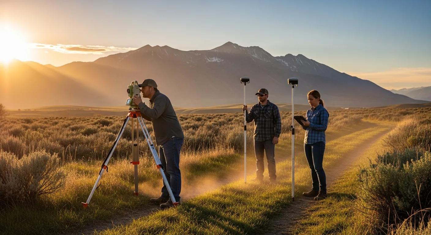
What Should You Expect During Your Land Surveying Appointment in Spanish Fork?
On site, our surveyors set control, search for existing monuments, measure property corners, and record topographic features using GPS, total stations, or drone equipment as appropriate to the scope. Property owners can help by marking gates, sharing access notes or codes, and clearing short sightlines where safe — small steps that speed fieldwork. After the field visit our office prepares certified maps, legal descriptions, and any requested CAD or electronic files; delivery timing will be included in the initial estimate. You can expect professional conduct, minimal disruption, and thorough documentation. Call For Service: to get started, contact Ludlow Engineers and Associates at (435) 623-0897 or use our Spanish Fork inquiry options and provide parcel details to request a quote.
Choosing the right survey depends on your transaction and project needs — we’ll help you match scope to purpose.
Integrated survey and engineering services are often the most efficient option for construction projects in Spanish Fork. Call For Service: contact Ludlow Engineers at (435) 623-0897 to discuss combined survey and engineering packages tailored to your needs.
Steps to get started:
- Gather property information such as address, parcel ID, and deeds.
- Call (435) 623-0897 to describe the purpose and request a scoped estimate.
- Schedule a site visit and provide access notes or gate codes if needed.
Following these steps helps us deliver accurate, timely results that meet your transaction or construction requirements.
The U.S. Rectangular Public Land Survey System (RPLSS) has shaped land division since 1785 and remains a foundational element of how many parcels are described today.
Frequently Asked Questions
What should I do if I have a boundary dispute with my neighbor?
Start by ordering a professional boundary survey — it provides a certified legal description and map of your property lines. Share the results with your neighbor to seek an amicable solution. If an agreement can’t be reached, consider mediation or legal counsel; a professional survey strengthens your position in formal proceedings.
How can I prepare for a land survey appointment?
Gather the property deed, any prior surveys, and the parcel number before the appointment. Ensure gates are unlocked and clear obvious obstacles to give survey crews safe access. Mark any areas of concern you want the crew to note. These simple steps help the team work efficiently and make the survey more accurate.
What are the common challenges faced during land surveys in Spanish Fork?
Common challenges include steep or brush-covered terrain, locked gates or difficult access, and incomplete or ambiguous historical records that require extra research. Knowing these potential issues ahead of time helps you prepare and keeps the survey process moving smoothly.
Can I use a survey from a previous owner when buying a property?
You can use a prior survey, but it may be outdated if boundaries, easements, or structures have changed. If the survey is several years old or the property has seen significant change, ordering a new survey is the safest option to ensure accurate, legally defensible information.
What is the role of technology in modern land surveying?
Technology improves accuracy and speed: GPS, total stations, and drones capture precise field data, while CAD and GIS software turn that data into detailed maps and models. Drones are especially useful for large or difficult sites, and integrated software streamlines delivery of files for design and permitting.
How often should I have my property surveyed?
Frequency depends on changes to the property, planned construction, or disputes. Survey whenever you plan significant improvements, buy or sell a parcel, or suspect boundary issues. Regular surveys help maintain clear property records and prevent surprises.