Boundary Surveys Near You: What’s Included, When to Order One, and What Drives Cost
A boundary survey establishes the exact lines of a property — a step every homeowner, real estate professional, and developer should understand. This guide explains what a boundary survey covers, when you should get one, and the main factors that affect price. Whether you’re buying, selling, applying for permits, or planning construction, a proper survey reduces disputes and keeps projects on track. Below you’ll find clear definitions, common situations that call for a survey, the typical deliverables, pricing guidance, and tips for finding a trusted surveyor .
What Is a Boundary Survey and Why It Matters
A boundary survey is a licensed surveyor’s determination of a property’s legal limits. It identifies property lines on the ground and on maps, helping prevent neighbor disputes, support real estate closings, and ensure compliance with local zoning and permitting requirements. The survey produces legal documentation you can rely on. boundary survey.
What Boundary Surveys Do and Why They’re Used
Boundary surveys do three core things: locate property corners, document the results on a certified plan, and provide a legal record you can present to lenders, title companies, or municipal agencies. Licensed surveyors combine public records, historical plats, and field measurements to re-create accurate boundaries and resolve conflicting information when it appears.
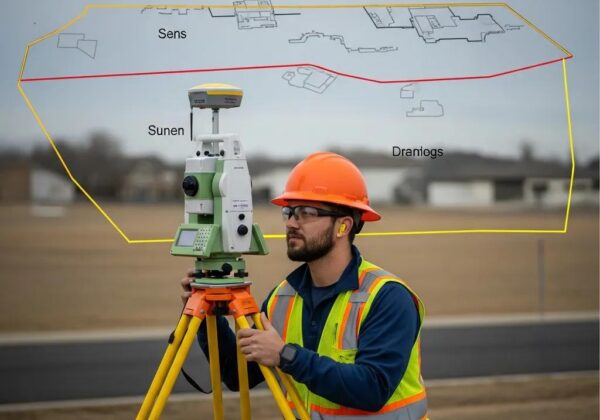
How Property Corner Pins Define Your Land
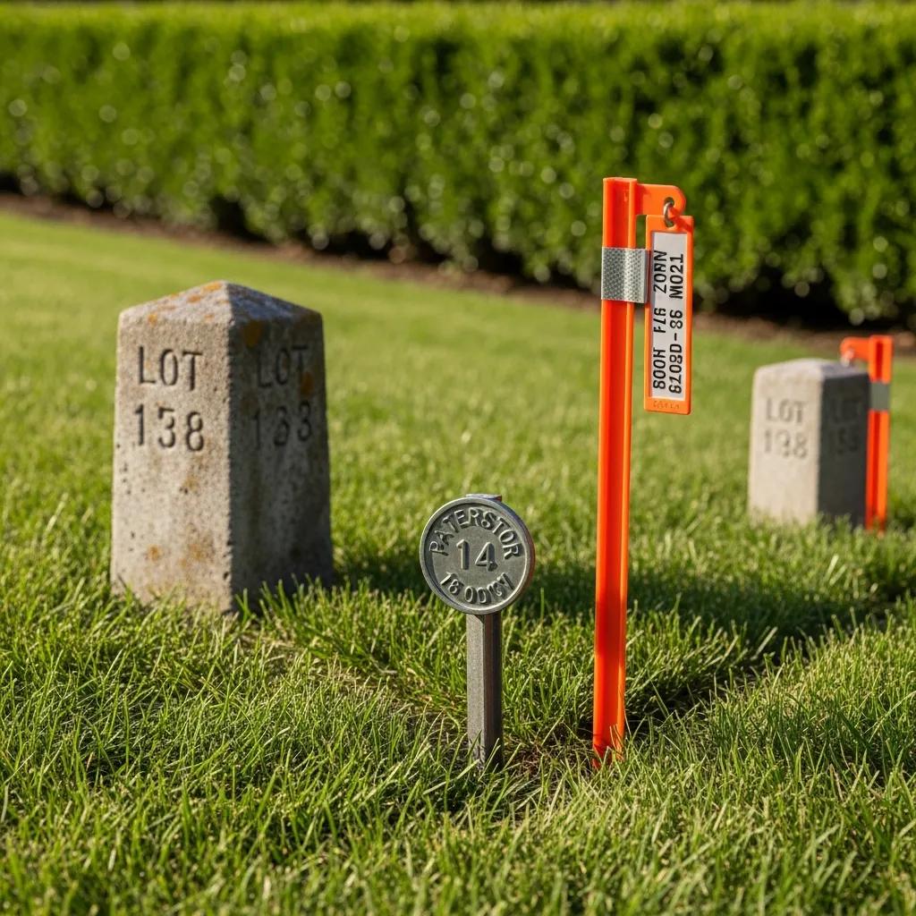
Property corner pins are the physical markers set where parcel corners are legally located. Installed by surveyors, these durable markers — often metal, plastic, or concrete — give a visible, long-term reference for property lines. Because pins are used in legal descriptions and boundary disputes, proper placement and documentation are essential.
Accurately marking and re-establishing these corner points is central to surveying and frequently uses retracement techniques to follow original surveys.
Retracement Survey Methods for Re-establishing Property Corners
The goal is to retrace the original surveyor’s work as closely as possible to re-establish the property corners.
Retracement and apportionment as surveying methods for re-establishing property corners, 1959
When Should You Order a Boundary Survey?
Common Situations That Require a Land Survey
- Buying or Selling Property : Lenders, title companies, or buyers often request a survey to confirm boundaries and avoid surprises at closing — even when not strictly required by law.
- Building Permits : Municipalities commonly require a recent boundary survey as part of permit reviews to check setbacks and zoning compliance.
- Land Development : Developers and builders use surveys for site planning, lot layout, and to ensure construction stays within legal limits.
Legal and Construction Reasons to Get a Boundary Survey
Beyond transactions and permitting, surveys play a critical role in resolving neighbor disputes, clarifying title questions, and supporting subdivision or land division. Clear, professionally documented boundaries reduce the risk of costly legal action and keep construction projects moving without unexpected delays.
Precise boundary determination matters most in complex processes like subdivision, where measurements directly affect lot size, value, and legal compliance.
Boundary Determination in Subdivision Work
The accuracy of existing outer boundaries is essential when dividing a property into smaller parcels. Better-defined boundaries lead to clearer area calculations and more reliable property valuations.
Determination of real estate boundaries for the purposes of subdivision process, A Bieda, 2010
What Is Included in a Boundary Survey?
Typical Steps and Methods Surveyors Use
- Initial assessment: Review deeds, plats, and public records to establish the property’s legal framework.
- Fieldwork: Visit the site to locate monuments, measure existing evidence, and set new markers where required.
- Final report: Deliver a stamped survey plan and supporting documentation showing corners, bearings, distances, and any encroachments or easements.
Tools and Technology Used in Modern Surveys
Today’s surveys blend proven practice with modern instruments. Surveyors commonly use differential GPS, total stations, electronic data collectors, and, where helpful, drones for aerial context. These tools speed fieldwork and improve the positional accuracy of the final deliverables.
How Much Does a Boundary Survey Cost?

Key Factors That Influence Survey Pricing
- Property size: Larger parcels typically require more time to research and measure, raising the cost.
- Location: Local labor rates, access, and travel can affect the price.
- Survey complexity: Irregular boundaries, dense vegetation, existing disputes, or a need to retrace old monuments increase time and expense.
Typical Price Ranges for Boundary Surveys Near You
As a general guide, boundary surveys commonly range from $350 to $1,500 depending on the items above. A straightforward residential lot often falls in the $350–$500 range, while larger or more complex commercial parcels can exceed $1,200. Use these ranges to set expectations and compare quotes responsibly.
This table highlights typical services and their price bands; actual costs depend on your property’s specifics and the scope you request.
How to Find a Reliable Boundary Surveyor Near You
Practical Tips for Choosing a Qualified Surveyor
- Verify credentials: Confirm the surveyor is licensed in your state and carries professional liability insurance.
- Request references: Ask for recent examples of similar work and follow up with past clients when possible.
- Compare quotes: Get several detailed proposals so you can compare scope, timeline, and price rather than picking solely on cost.
Questions to Ask Before You Hire
- Do you have experience with projects like this in my area?
- Are you insured and do you provide a written scope with a stamped plan?
- What is the expected timeline from fieldwork to final deliverables?
What Are Property Corner Pins and How Are They Used?
Common Types of Corner Markers
- Metal pins: Durable, permanent markers commonly used for long-term monuments.
- Plastic stakes: Temporary or short-term markers used during construction or initial staking.
- Concrete monuments: Heavy, permanent markers used where a long-lasting reference is required.
Maintaining and Replacing Property Corner Pins
To keep boundaries clear, check markers periodically and contact a licensed surveyor if pins are missing, moved, or damaged. A professional can locate the original corners, reset pins properly, and document the work. Learn more about the replacement process and legal considerations on our blog .
Following these guidelines — and hiring a qualified surveyor — helps protect your property, reduce conflict, and support future development decisions with confidence.
Frequently Asked Questions
What qualifications should I look for in a boundary surveyor?
Look for a licensed professional surveyor in your state with relevant field experience and professional liability insurance. Membership in industry groups and a record of completed projects similar to yours are also strong indicators of competence.
How long does a boundary survey typically take?
Timeframes vary by size and complexity. A simple residential survey can often be completed in a day of fieldwork with additional days for office mapping and a stamped plan. Larger or disputed sites may take several days on-site plus more time for research and documentation.
Can I perform my own boundary survey?
You can take informal measurements, but a licensed surveyor provides the legal record, access to historical documents, and technical tools necessary for an accurate, defensible boundary. For transactions, permits, or disputes, hire a professional.
What happens if there is a dispute over property boundaries?
A boundary survey supplies documented evidence of lines and corners that can resolve many disputes. If parties still disagree, survey results often form the basis for mediation or legal action; consulting an attorney experienced in real estate helps navigate that path.
Are boundary surveys required for all real estate transactions?
Not always. Some transactions proceed without a new survey, but lenders, title companies, or local authorities may require one. When in doubt — or when construction or unclear boundaries are involved — ordering a current survey is prudent.
What should I do if my property corner pins are missing or damaged?
Contact a licensed surveyor to locate and re-establish the original corners and replace markers as needed. Prompt action prevents boundary confusion and potential disputes with neighbors.
Conclusion
A clear, professionally prepared boundary survey protects property value and reduces surprises during transactions or construction. Working with a licensed, experienced surveyor gives you a reliable legal record and the confidence to move forward with buying, selling, building, or subdividing. If you have questions about your property lines or need a stamped plan, reach out to a qualified surveyor today to get started.