Land Survey Cost Breakdown for Accurate Estimation
When planning for a land survey, property owners and real estate professionals face uncertainties about the factors driving the cost. Accurate estimation is crucial for due diligence during real estate transactions, budgeting future improvements, and complying with local regulations. This article outlines key cost components—from fieldwork expenses to office research fees—and explains how factors such as terrain and vegetation density affect pricing, empowering clients to make informed decisions and negotiate fair estimates.
Key Takeaways: Understanding Your Land Survey Cost Breakdown
- A comprehensive cost breakdown clarifies expenses incurred during fieldwork, office work, equipment use, travel, and monumentation.
- Factors such as property size, terraincomplexity, and record quality significantly affect the survey cost.
- Different survey types (boundary, topographic, ALTA/NSPS, construction staking, subdivision platting) have varying fee structures.
- Clear project requirements and accurate estimates help prevent unexpected fees and ensure the survey scope matches the budget.
Understanding Core Components of Your Land Survey Cost Breakdown

Accurate land survey cost estimation relies on understanding several core components: fieldwork expenses, office work and research, equipment and technology usage, travel and mobilization costs, and monumentation fees.
Defining Fieldwork Expenses in a Land Survey Cost
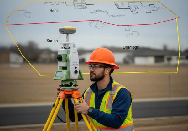
Fieldwork expenses cover on-site labor needed to collect data, mark boundaries, and inspect the property. Costs include wages for the survey crew and operational expenses for equipment. For instance, surveying a rugged terrain will increase both time and physical effort compared to a simple residential lot survey. Property size and complexity directly influence the overall cost.
Office Work and Research Fees Within the Survey Cost Breakdown
Office work and research fees cover the analysis that supports field data. This includes reviewing public records, prior survey reports, and preparing maps and legal descriptions. Time spent using advanced mapping software and compiling legal documents is factored into the cost, ensuring the final survey is accurate and legally sound.
The Impact of Equipment and Technology on Survey Pricing
Using advanced equipment such as high-precision GPS, total stations, drones, and specialized software improves measurement accuracy and efficiency. However, these tools and their maintenance add to the cost. In areas where terrain requires specialized equipment, the overall pricing can increase noticeably, with costs distributed over multiple projects.
How Travel and Mobilization Affect the Land Survey CostWhat is the average cost of a land survey??How do surveyors calculate land survey costs??
Travel and mobilization costs include expenses for moving survey teams and equipment to the property. Factors such as fuel, vehicle rental, and travel allowances become more significant when the property is remote or hard to access. Additionally, costs may rise if temporary accommodation or logistical support is needed during extended surveys or adverse weather conditions.
Understanding Monumentation Fees in Your Estimate
Monumentation fees are charges for placing or restoring survey markers and boundary monuments. They cover the cost of durable materials—such as metal rods or concrete markers—used to clearly demarcate property lines. Expenses vary with soil conditions, property size, and any physical obstructions. In areas with vandalism risk or natural disturbances, additional stabilization measures may further increase costs.
Key Factors Driving Your Overall Land Survey Cost Estimation
Beyond the basic components, several factors affect the overall survey cost by influencing the effort and precision required.
Property Size and Shape Influence on Survey Expenses
Larger properties require more extensive fieldwork and data collection. Irregular or non-standard shapes, such as curved boundaries or lots with outcroppings, may require specialized techniques to accurately mark boundaries, thus raising costs. In contrast, compact, rectangular lots often result in lower fees due to simpler layouts.
TerrainComplexity and Accessibility in Cost Calculation
Surveying flat, open areas is generally less challenging compared to hilly, forested, or steep terrains. Difficult topography may necessitate extra time, advanced equipment, or even aerial imaging, all of which contribute to higher costs. Additionally, accessibility issues, such as the need to create temporary roads, further add to the survey expenses.
Vegetation Density and Its Effect on Survey Duration and Price
High vegetation density can obscure landscape details and complicate boundary identification. In heavily forested or overgrown areas, additional labor may be required to clear sightlines or supplement measurements with aerial drones. This need for extra time and technology elevates both labor and equipment costs, ensuring final survey results meet regulatory standards.
The Role of Record Availability and Quality in the Cost Breakdown
The availability and quality of historical records affect the research workload. Properties with well-documented histories require less extensive office work compared to those with incomplete or outdated records. Quality documentation reduces the risk of boundary disputes and minimizes extra consultation or correction fees.
Required Precision and Detail Level for Your Project
Client requirements regarding precision and detail dictate final costs. High-resolution surveys—necessary for engineering developments, legal disputes, or high-value transactions—often demand multiple passes and advanced equipment, increasing time and expense. Projects with lower precision needs may require less effort, thereby reducing the cost.
Different Land Survey Types and Their Typical Cost Structures

Various types of land surveys address different needs. Each survey type incorporates its own set of cost components and pricing structures essential for budgeting and planning.
Boundary Survey Cost Breakdown Specifics
Boundary surveys determine exact property lines, often used for dispute resolution or confirming legal descriptions. They typically involve fieldwork to locate physical markers, extensive research, and potentially reinstallation or repair of monuments. Because of the high accuracy and documentation demands, boundary surveys tend to be more expensive than general-purpose surveys.
Topographic Survey Pricing Considerations
Topographic surveys focus on capturing the contours and natural features of a landscape. They are critical in construction planning and landscape design. Costs include extensive field data capture with drones or laser scanners, detailed mapping, and data processing. Terrainelevation changes and vegetation obstructions can add extra fees.
ALTA/NSPS Land Title Survey Cost Elements
ALTA/NSPS surveys meet stringent standards required by title insurance companies and lenders. These comprehensive surveys cover boundary lines, easements, and encroachments and require thorough field and office work. Due to their precise legal requirements, ALTA/NSPS surveys command a premium price.
Construction Staking Survey Fee Structure
Construction staking surveys establish where structures will be built. They include labor for setting markers, use of specialized equipment, and sometimes multiple site visits for verification. If initial plans differ from field conditions, additional visits may be necessary, resulting in higher costs.
Subdivision Platting Survey Cost Estimation Factors
Subdivision platting divides a tract of land into smaller lots. This process involves detailed boundary documentation, collaboration with local authorities for zoning and utility mapping, and extensive planning. Given the complexity and legal implications, subdivision surveys are often the most detailed and costly type.
Achieving an Accurate Land Survey Cost Estimation
Obtaining an accurate cost estimate is key to a smooth project execution. Clear requirements and detailed quotes are essential steps in this process.
Providing Clear Project Requirements to Surveyors
Clear project descriptions help surveyors understand exactly what is needed. This includes detailed property descriptions, the required level of precision, and any special considerations. Ambiguities may lead to extra charges, so precise communication is vital.
Obtaining Multiple Quotes for a Comprehensive Cost Comparison
Gathering multiple quotes from reputable surveyors allows for effective cost comparison. This competitive approach not only helps in identifying the best value but also in revealing potential areas for cost savings.
Verifying Surveyor Credentials and Experience
Ensuring that the surveyor is licensed and experienced reinforces the accuracy of the results. A proven track record justifies each cost component and reduces the risk of future disputes related to boundary identification.
Understanding What Is Included in Each Surveyor’s Cost Breakdown
Reviewing the service inclusions of each surveyor—whether it covers fieldwork, office research, equipment use, and travel fees—helps avoid unexpected expenses. A clear, itemized cost breakdown aids in comparing different providers effectively.
Asking About Potential Additional Charges or Contingencies
Discussing potential hidden charges, such as additional site visits or extra data processing fees, upfront can prevent unforeseen costs. Open dialogue about contingencies ensures that the project remains within budget.
Itemized Elements Within a Detailed Land Survey Cost Breakdown
A detailed, itemized cost breakdown supports accurate survey estimation. Below is a simplified table summarizing typical costs:
Before beginning the survey, reviewing this table with your surveyor can help pinpoint potential overcharges and identify areas for cost optimization.
Optimizing Your Investment With a Clear Land Survey Cost Breakdown
A transparent, detailed breakdown helps ensure that expenditures align with project needs and supports effective budgeting.
How a Detailed Breakdown Prevents Unexpected Expenses
When clients know exactly where every dollar is allocated, hidden fees or last-minute additions are less likely. Transparency builds trust and sets a clear cost structure from the beginning.
Using the Cost Breakdown for Project Budgeting
An itemized cost allows project managers to pinpoint negotiable elements and adjust survey scope or precision as needed, potentially lowering overall expenses without compromising quality.
The Long-Term Value of an Accurate Survey Versus Initial Cost
While high-quality surveys come with significant upfront costs, they can prevent future legal disputes, boundary errors, and construction mistakes—providing long-term financial benefits.
Identifying Areas for Potential Cost Savings Without Sacrificing Quality
Experienced surveyors may suggest cost efficiencies such as optimized fieldwork routes or dual-use equipment. Clients should inquire about these options while ensuring the survey remains thorough and accurate.
Ensuring the Survey Scope Matches Your Needs and Budget
Finally, the survey’s scope should match both project requirements and financial constraints. By discussing details and reviewing the breakdown, clients can negotiate modifications that suit their budget.
Final Thoughts
Accurate land survey cost breakdowns are vital for property owners and real estate investors looking to manage budgets effectively and protect investments. Understanding every component—from fieldwork to legal monumentation—enables better anticipation of expenses. A detailed discussion, verification of surveyor credentials, and comparing multiple quotes ensure that the survey process remains transparent and cost-effective. In the long term, investing in a carefully documented survey can mitigate risks and support smoother property transactions.
Frequently Asked Questions
Q: How does property size influence survey costs? A: Larger properties require more extensive fieldwork and data collection, which naturally increases labor and equipment costs.
Q: Can difficult terrain significantly raise survey prices? A: Yes, complex topography and accessibility challenges necessitate specialized equipment and additional fieldwork time, thereby increasing overall expenses.
Q: What is included in a typical ALTA/NSPS survey fee? A: These surveys include precise boundary measurements, historical record research, and installation of markers, often commanding a premium due to stringent requirements.
Q: How can clients avoid unexpected additional fees? A: Clear communication of project requirements, obtaining multiple quotes, and reviewing a detailed cost breakdown help identify potential extra charges before they occur.
Q: Why is a detailed survey valuable for long-term property investments? A: Accurate surveys prevent legal disputes and construction errors, safeguarding property values and reducing unforeseen financial risks.