Local Property Survey Insights
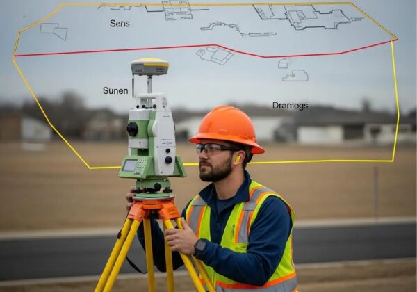
A property survey shows exactly where a parcel’s boundaries, easements, and any encroachments sit. This guide explains typical costs, the maps and reports you’ll receive, usual timelines, and how to find a dependable land surveyor near you. Read on for the practical information you need whether you’re buying, selling, or planning new construction.
Accurate, well-documented boundary work affects a property’s value and legal standing — the evidence supports that link.
Importance of Accurate Real Estate Boundary Determination
Precise boundary determination is fundamental for subdivision and land valuation. Property area — derived from surveyed boundaries — influences market price and, in some cases, payments tied to agricultural land. Clear boundary definitions make value and compensation far more reliable.
Determination of real estate boundaries for the purposes of subdivision process, A Bieda, 2010
How Much Does a Property Survey Cost Near Me in Utah?
Survey costs in Utah depend on the work. For many standard boundary surveys, expect roughly $400 to $1,200. Complexity, terrain, and the survey type all change the final price, so budget with those variables in mind.
What Factors Influence Property Survey Pricing?
- PropertySize and Complexity: Larger parcels or sites with irregular shapes, heavy vegetation, or multiple structures take more time and therefore cost more.
- Type of Survey Required: A basic boundary survey is quicker than an ALTA/NSPS or a full topographic survey, which demand more detail and documentation.
- Geographical Location: Remote locations, permitting hurdles, or local rules can add travel and administrative time — and increase cost.
Discuss these factors with your surveyor so the estimate reflects the work needed for your property.
How Do Boundary Survey and ALTA Survey Costs Compare?
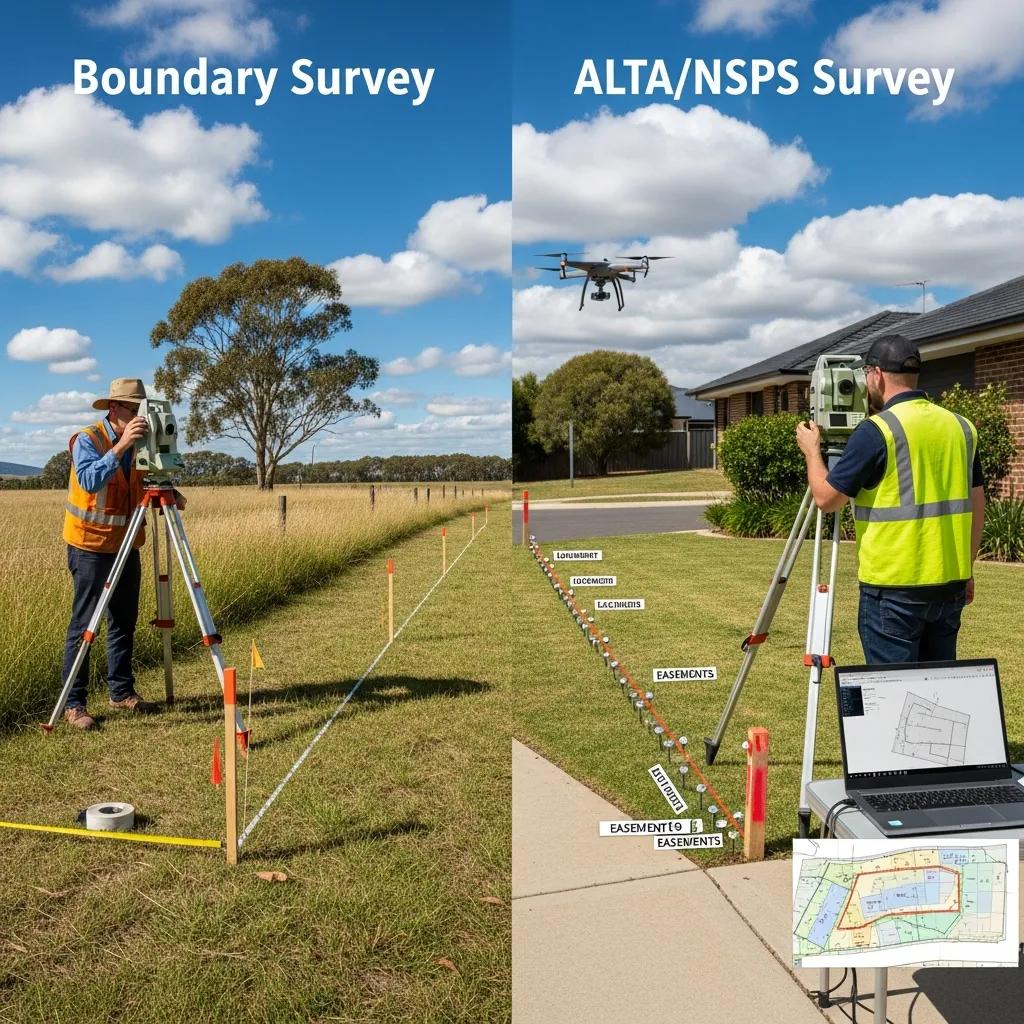
Pick the survey that fits your goal — a homeowner resolving a line dispute may only need a boundary survey, while lenders and title companies typically require an ALTA/NSPS survey.
What Will You Receive from a Property Survey Service?
Hiring a licensed surveyor delivers a set of documents and maps that define your property’s physical and legal limits. These deliverables protect your interests and support real estate or construction decisions.
What Is Included in a Standard Boundary Survey Report?
- Legal Descriptions: Formal written descriptions of the property lines usable in deeds and legal records.
- Maps and Diagrams: Scaled drawings showing property lines, corners, easements, and any observed encroachments.
- Surveyor‘s Certification: A signed statement from the surveyor verifying methods used and the accuracy of measurements.
These items are the foundation for title work, permitting, and dispute resolution.
What Additional Documents Come with an ALTA/NSPS Land Title Survey?
An ALTA/NSPS survey adds the detail title companies and commercial lenders expect. Typical inclusions are:
- Title InsuranceRequirements: Documentation formatted to ALTA/NSPS standards so title companies can underwrite risk.
- Detailed PropertyDescriptions: Expanded notes and drawings showing improvements, utilities, and other features that affect title.
- Zoningand Land Use Information: Notes on zoning classifications or restrictions that may affect development potential.
These deliverables reduce surprises during transactions and give lenders the assurance they need.
How Long Does a Property Survey Take Near Me in Utah?
Turnaround varies by survey type and site conditions. Most surveys finish within one to four weeks from first contact; complex jobs or permitting can extend that timeline.
What Are the Typical Steps in the Land Survey Process?
- Initial Consultation: We review property records, your objectives, and any title or permitting needs.
- Fieldwork and Data Collection: On-site measurements, monument searches, and data capture (GPS, field notes, and observations).
- Report Preparation: Producing maps, legal descriptions, and the surveyor’s certification for delivery.
Each step ensures the final survey is accurate and defensible.
How Do Modern Technologies Like UAV Aerial Surveying Affect Survey Duration?
UAV (drone) surveys and advanced GPS tools speed data collection and improve accuracy on large or difficult sites. They can reduce field time and help deliver maps and models faster without sacrificing quality.
When and Why Do You Need a Property Survey?
Getting a survey at the right time helps you avoid costly mistakes. Surveys are commonly required for real estate closings, building permits, and any project that depends on exact boundary or topographic information.
Do You Need a Property Survey for Real Estate Closings or New Construction?
Often, yes. Surveys help you:
- Ensure Legal Compliance: Confirm the property meets zoning and setback rules before you build.
- Mitigate Risks: Identify boundary disputes or encroachments early so they don’t derail a sale or project.
- Facilitate Financing: Lenders and title companies often require surveys to verify what they’re lending against.
A current survey reduces risk and keeps transactions moving.
What Is the Difference Between Boundary Surveys and ALTA/NSPS Surveys?
Boundary surveys locate and document property lines and corners. ALTA/NSPS surveys are broader — combining boundary work with detailed topography, recorded easements, and other items required for commercial closings and title insurance. Choose the scope that fits your legal and financial needs.
How to Find a Reliable Land Surveyor Near Me in Utah?

Pick a surveyor with local experience, current licensure, and a clear record. The right professional will explain the steps, costs, and how deliverables will be used in your transaction or project.
What to Look for in a Professional Land Surveyor?
- Licensing and Certifications: Verify the surveyor is licensed in Utah and holds required certifications.
- Experience in Local Surveying: Local knowledge matters — familiarity with county records, common boundary issues, and permitting speeds the job.
- Client Testimonials: Reviews, references, and samples of past surveys show how the firm communicates and the quality of deliverables.
Those checks help you find a surveyor who will deliver reliable, defensible results.
How Does Ludlow Engineers and Associates Provide Trusted Survey Services?
Ludlow Engineers and Associates (doing business as Ludlow Engineering) has served Utah since 1975. With decades of civil engineering and land surveying experience, we perform boundary surveys, ALTA/NSPS title surveys, topographic mapping, and more. Our local expertise and straightforward communication make us a practical choice for property owners, developers, and lenders.
What Are the Latest Trends and Regulations Affecting PropertySurveys in Utah?
Survey standards and local rules change over time. Staying current helps ensure surveys meet permitting and title requirements while taking advantage of new technologies that increase efficiency and reduce environmental impact.
How Do Utah’s Land Use and Zoning Changes Impact Survey Requirements?
Recent land use and zoning updates can change what surveyors must show. Typical impacts include:
- Increased Documentation: Some jurisdictions now request more detailed mapping or additional notes to meet new ordinances.
- Environmental Considerations: Surveys may need to identify protected areas, critical slopes, or waterways for land-use reviews.
Working with a local surveyor helps ensure your survey meets current permitting and development standards.
What Are the Benefits of Sustainable and Digital Surveying Techniques?
Modern, sustainable methods offer clear advantages:
- Efficiency Improvements: Digital tools and remote sensing reduce field hours and speed delivery.
- Environmental Benefits: Less intrusive methods limit site disturbance during data collection.
- CostSavings: Faster capture and automated processing can lower overall project costs.
These advances make surveys faster, greener, and often more cost-effective.
Frequently Asked Questions
What should I consider when choosing a land surveyor?
Prioritize licensing, experience, and local knowledge. Confirm the surveyor is licensed in your state and has relevant certifications. Look for professionals with a track record in your area — they’ll understand county records, common boundary issues, and permitting. Read testimonials and request examples of past surveys to judge communication and quality. A good surveyor will explain the process and deliverables clearly so you feel confident.
Can I perform my own property survey?
You can do a basic visual check, but a professional survey is necessary for legal accuracy. DIY efforts usually lack the precision and legal standing required for real estate transactions or disputes. Licensed surveyors use specialized equipment and methods to ensure accurate boundaries and compliance with local rules. For sales, permits, or legal matters, hire a qualified surveyor.
What happens if my property survey reveals encroachments?
If a survey identifies encroachments, address them promptly. Encroachments can cause neighbor disputes and affect property value. Start by discussing findings with your surveyor to understand implications. Often the next step is negotiating a resolution with the other party; in some cases you may need legal advice or formal action. A real estate attorney can guide the best course of action.
How do propertysurveys impact property taxes?
Surveys can affect property taxes by providing accurate measurements of land and improvements. Assessors use survey data when determining value, which influences tax assessments. If a survey reveals size or boundary discrepancies, it may prompt a reassessment. Keeping surveys current helps ensure you’re taxed on accurate information and can support appeals if needed.
What are the legal implications of a property survey?
A property survey has legal weight: it documents official boundaries and easements. That documentation is key for resolving disputes, complying with zoning rules, and completing real estate transactions. A professionally prepared survey can serve as critical evidence in legal matters, so maintaining an accurate, up-to-date survey protects your property rights.
Are there any environmental considerations in propertysurveys?
Yes. Environmental factors are increasingly important. Surveyors may need to mark protected areas, wetlands, or sensitive habitats. Local regulations often require surveys to show environmental features that could affect land use or development. Using sustainable surveying methods can also reduce site impact and align with conservation goals.
What types of propertysurveys are available besides boundary and ALTA/NSPS surveys?
Other common surveys include topographic surveys (showing elevations and contours), construction staking surveys (laying out building footprints and utilities), and subdivision surveys (dividing a parcel into lots). Each serves a specific purpose — choose the type that matches your project needs.
How can I prepare for a property survey?
Gather deeds, prior surveys, and title reports. Mark visible corners if you can, clear obvious vegetation that blocks access, and list questions for the surveyor. The more background you provide, the smoother fieldwork will be.
What should I do if I disagree with the results of my property survey?
First, review the report with the surveyor and ask for clarification on records and methods used. If issues remain, request a review or hire an independent surveyor for a second opinion. In serious disputes, legal counsel or a court-ordered survey may be necessary.
Are propertysurveys required for refinancing a mortgage?
Not always — requirements vary by lender and property type. Many lenders do ask for a current survey to confirm boundaries and rule out encroachments. Check with your lender before you refinance to see what they need.
What are the potential risks of not having a property survey?
Without a current survey you risk boundary disputes, unnoticed encroachments, zoning noncompliance, or costly mistakes during construction. A survey protects your property rights and helps avoid surprises in transactions.
How often should propertysurveys be updated?
Update surveys after significant changes: new construction, changes to property lines, subdivision, or documented disputes. When buying or selling, a recent survey ensures accurate information for everyone involved.
Conclusion
Propertysurveys are practical safeguards — they clarify boundaries, lower risk, and support smart real estate and construction choices. Understanding costs, deliverables, and timelines helps you plan with confidence. When accuracy matters, work with an experienced, licensed surveyor. If you’re ready, contact us to discuss the right survey for your project and get a clear, reliable plan in place.
Conclusion
Propertysurveys are essential tools that define boundaries, reduce uncertainty, and improve decision-making for real estate and construction work. Knowing typical costs, expected deliverables, and likely timelines lets you plan effectively and avoid surprises. Partnering with a licensed, experienced surveyor ensures accurate, defensible results tailored to your needs. Ready to move forward? Reach out and we’ll help you choose the right survey for your project and set a clear path ahead.