Expert Land Surveyors in Utah County: Ensuring Precision and Integrity
Ludlow Engineers provides professional land surveying and civil engineering services across Utah County, offering boundary, ALTA, topographic, and UAV surveys that support residential and commercial projects. If you need on-the-ground measurements, title-ready plats, or drone-based site mapping, Call For Service — Ludlow is available locally in Utah County to evaluate sites, prepare quotes, and schedule field work. This article explains the core survey types available in Utah County, how modern technology like drones and LiDAR improves accuracy and speed, and what typical cost factors mean for homeowners and developers. You will learn when to order a boundary or ALTA/NSPS land title survey, how topographic and UAV surveys feed civil site plans, and why FHA foundation inspections matter for manufactured homes. The following sections cover key services, topographic and UAV methods, reasons to choose Ludlow Engineers, cost guidance with comparative tables, integration with civil engineering and FHA inspections, and practical FAQs to help you select the right surveyor in Utah County.
What Are the Key Land Surveying Services Offered in Utah County?
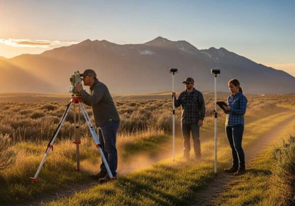
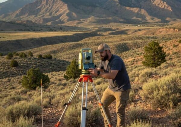
A core set of land surveying services in Utah County includes boundary surveys, ALTA/NSPS land title surveys, topographic mapping, construction staking, UAV aerial surveying, subdivision platting, and FHA foundation inspections; each service produces specific deliverables such as plats, legal descriptions, contours, and monument placement. Boundary surveys establish and mark property lines by reconciling record research and field measurements, producing a legal plat and monuments that resolve ownership questions and support transactions. ALTA surveys follow national standards for commercial real estate and include Table A items when requested, helping lenders and title companies assess encumbrances and easements. Topographic and UAV surveys create contours, point clouds, and ortho imagery that feed civil designs and grading plans, while construction staking translates site plans into field positions for contractors.
These primary services are often chosen for different use cases in Utah County:
- Boundary Survey: Resolve property line questions, place fences, and support lot splits.
- ALTA/NSPS Survey: Support commercial closings, title insurance, and lender requirements.
- Topographic Survey: Provide elevation data for site planning, grading, and drainage design.
- UAV Aerial Surveying: Capture rapid site-wide imagery, volumetrics, and hard-to-reach areas.
Understanding how deliverables differ helps property owners and developers pick the right survey; the next section defines boundary surveys in practical terms and when they are required.
What Is a Boundary Survey and When Is It Needed in Utah County?

A boundary survey determines the legal limits of a parcel by combining title research, deed interpretation, coordinate measurement, and monument setting to provide an authoritative plat and legal description. This process reconciles historical records, monuments, and physical improvements so that property lines can be accurately shown for fence placement, property transfers, or subdivision work. Boundary surveys are commonly needed when buying or selling property, when a fence or structure is placed near a presumed property line, and when resolving neighbor disputes; surveyors document findings with a signed plat and may set monuments to mark the corners. Because local records and physical evidence sometimes conflict, an experienced surveyor will trace chain-of-title issues and verify monuments to reduce ambiguity before proceeding, and that verification prepares the site for subsequent surveys or development.
How Do ALTA Surveys Support Commercial Real Estate in Utah County?
An ALTA/NSPS land title survey is a comprehensive commercial survey designed to meet title insurance and lender requirements by showing property boundaries, easements, rights-of-way, and improvements according to nationally recognized standards. ALTA surveys include mandatory elements plus optional Table A items that specify additional deliverables—such as utility locations, floodplain notes, or precise building measurements—so lenders and title companies can underwrite risk accurately. In Utah County commercial transactions, ALTA surveys reduce closing delays by clarifying encumbrances, confirming access, and providing coordinate-accurate plats that integrate with title commitments and closing documents. Because ALTA work often requires coordination with title companies and engineering teams, ordering an ALTA early in the transaction helps avoid surprises during due diligence and speeds lender approvals.
The ALTA/NSPS Standards are a critical framework for commercial real estate transactions, ensuring a consistent level of detail and accuracy.
How Does Ludlow Engineers Provide Topographic and UAV Aerial Surveying in Utah County?
Topographic surveys measure the three-dimensional shape of land to produce contours, spot elevations, and mapped features that engineers use for grading, drainage, and utility design; Ludlow Engineers combines field GPS/GNSS, total station work, and UAV photogrammetry to create accurate base maps. The process begins with project scoping and flight or field plans to ensure required accuracy, continues with data capture using drones or LiDAR scanners when appropriate, and concludes with processing into contours, point clouds, and deliverables formatted for civil design. Drones reduce field time on steep or inaccessible sites while LiDAR provides dense elevation data for wooded or complex terrain; this combination reduces schedule risk and gives designers actionable datasets. Deliverables typically include DWG-ready base maps, contour sheets, ortho imagery, and point cloud exports that integrate directly into site plans for permitting and construction.
Benefits of combining topographic and UAV methods include:
- Faster data capture: UAVs survey acres per hour compared to traditional ground methods.
- Higher-resolution deliverables: Photogrammetry and LiDAR produce detailed contours and point clouds.
- Safer fieldwork: Remote capture reduces time spent on hazardous slopes or infrastructure.
What Are the Benefits of Topographic Surveys for Utah County Land Development?
Topographic surveys supply elevation models and feature mapping that guide design decisions about grading, drainage, and infrastructure placement, which reduces rework and accelerates permitting for Utah County developments. Accurate contours identify natural drainage patterns and spot elevations that determine whether retaining walls, culverts, or specific grading plans are needed, enabling engineers to design with real-world constraints. When topographic data is integrated into civil site plans, it reduces change orders during construction because contractors receive precise stakeout and cut/fill information. For developers, reliable topo surveys translate into clearer cost estimates, fewer permit revisions, and a smoother path from concept to build, particularly in sloped or hydrologically sensitive parcels.
How Are Drones and UAV Technology Used in Utah County Land Surveys?

Drones and UAVs capture high-resolution aerial imagery and, when combined with ground control, produce orthophotos, digital elevation models, and point clouds used for volumetric calculation, progress monitoring, and site reconnaissance across Utah County projects. Flight planning establishes ground control points and permitted airspace, data capture collects overlapping imagery or LiDAR points, and software processes produce georeferenced deliverables that meet accepted accuracy targets. UAV methods are especially valuable on large commercial sites, quarries, and during construction for frequent updates without repeated ground crews, although photo-based photogrammetry trades off some vertical precision against LiDAR in vegetated areas. Knowing these trade-offs helps project teams select the right sensor and workflow to balance cost, accuracy, and schedule.
Why Choose Ludlow Engineers as Your Commercial and Residential Land Surveyor in Utah County?
Ludlow Engineers and Associates brings long-standing Central Utah presence and a client-first approach that emphasizes integrity, technical accuracy, and practical results for both residential and commercial projects in Utah County. Founded in 1975, the firm’s regional experience supports knowledgeable navigation of local permitting, coordination with county offices, and pragmatic solutions for common site constraints, which reassures owners and developers facing complex approvals. Ludlow’s service mix includes boundary and ALTA surveys, topographic and UAV mapping, and FHA foundation inspections for manufactured homes, enabling integrated workflows that reduce coordination overhead between survey and engineering teams. For a clear next step, Call For Service to request a site visit, ask about deliverables, or arrange a quote tailored to your property and project needs.
What Experience and Local Expertise Does Ludlow Bring to Utah County Surveys?
Ludlow Engineers’ regional history and service in Central Utah provide institutional knowledge about local platting practices, county record nuances, and municipal permitting expectations that speed approvals and reduce surprises during due diligence. Familiarity with the Utah County Surveyor’s office procedures, local utility providers, and typical neighborhood development patterns informs efficient research and field strategies, helping to reconcile old monuments and interpret deed language for accurate boundary resolution. This local experience is particularly helpful for subdivision platting and commercial site work where coordination with multiple agencies is required, and it supports project schedules by anticipating administrative timelines. Those practical advantages combine with technical skills to deliver plats and survey products that meet stakeholder needs for transactions and construction.
How Does Ludlow Ensure Accuracy and Client Satisfaction in Utah County?
Quality assurance at Ludlow includes systematic field validation, calibrated instruments, office QA checks, and clear deliverables that document methods and results so clients and third parties can rely on survey outputs. Field crews perform redundant measurements and monument verification, survey control is tied to recognized coordinate systems, and office processing includes cross-checks against record research and plat archives to verify consistency. Client communication emphasizes timelines, what deliverables include, and how survey findings may affect permitting or title commitments, while an emphasis on integrity and helping “the little guy” frames responsiveness and fair resolution of disputes. These practices reduce errors, build trust with clients, and make it easier for owners and developers to integrate survey data into engineering and title workflows.
What Are the Typical Costs and Factors Affecting Land Surveying Prices in Utah County?
Survey pricing in Utah County depends primarily on parcel size, terrain and access, complexity of record research, density of improvements, survey type (boundary vs ALTA), and requested accuracy or Table A items for ALTA surveys. A simple residential boundary on a small, accessible lot can be significantly less expensive than a commercial ALTA survey that requires extensive title research, utility locates, and optional Table A items; likewise, steep or heavily wooded parcels increase field time and equipment needs. Additional cost drivers include the need for monumentation, retracement of old corners, coordination with title companies, and whether UAV or LiDAR flights are required to meet deliverable specifications. For precise, site-specific pricing, Call For Service to obtain a custom quote that reflects actual site conditions and required deliverables rather than relying solely on generalized ranges.
How Much Does a Boundary or ALTA Survey Cost in Utah County?
Boundary surveys and ALTA surveys have different scopes and therefore different cost profiles: boundary surveys tend to focus on legal corners, monuments, and fence lines, while ALTA surveys add title-related items and often require more record research and coordination with title companies. ALTA surveys commonly cost more because Table A options increase field work, require specific verifications, and produce deliverables that lenders and title insurers rely on; conversely, a simple residential boundary survey omits many of those requirements and therefore is usually less expensive. Variables that commonly increase quotes include remote access, dense vegetation, ambiguous historical records, multiple ownership interests, and required monumentation; given these variables, Call For Service to receive a site-specific quote that reflects the actual scope rather than a generic estimate.
What Influences the Cost of Land Surveys for Residential vs. Commercial Properties?
Residential surveys typically involve smaller parcels, fewer encumbrances, and simpler deliverables focused on fences, setbacks, and plat records, whereas commercial projects more often require ALTA/NSPS surveys, topographic mapping, utility locates, and coordination with engineering and title teams. Commercial projects may include phased surveys for development, repeated construction staking, and higher accuracy tolerances that increase labor and equipment time; residential clients often need a single boundary plat and monumentation. Contracting models also differ: commercial work commonly uses formal proposals, project schedules, and coordination with engineers and contractors, while residential work may be delivered as a single survey contract with a straightforward turnaround. Understanding these scope differences helps property owners budget appropriately and choose the right deliverables for their needs.
How Do FHA Foundation Inspections and Civil Engineering Services Complement Land Surveying in Utah County?
FHA foundation inspections evaluate the load-bearing systems and anchoring of manufactured-home foundations to meet HUD/FHA standards required for certain loan programs, while civil engineering converts survey base data into designs for grading, utilities, and stormwater management that support permitting and construction. Survey data provides the base map—property lines, contours, and utility locations—that engineers use to design compliant foundations, septic systems, and drainage solutions in line with local codes. Coordinating FHA inspections with surveys and engineering reduces rework because an integrated team can align foundation elevations, tie-downs, and site grading early in the design process. For owners of manufactured homes and developers alike, combining survey, FHA foundation inspections, and civil engineering services streamlines approvals and helps avoid costly corrective work later.
What Is an FHA Foundation Inspection and Why Is It Important for Manufactured Homes in Utah County?
An FHA foundation inspection verifies that a manufactured home’s foundation, anchorage, and support system meet HUD criteria necessary for FHA-backed financing and for ensuring structural safety on the site, which lenders and insurers often require prior to loan closing. The inspection assesses anchorage, skirting, tie-downs, footing adequacy, and conformity with local installation standards, producing a documented report that lenders use to release funds or insure the loan. For manufactured-home owners in Utah County, obtaining this inspection is often critical to qualify for FHA loans, and ensuring compliance upfront prevents delays during mortgage processing. Integrating the inspection with survey data ensures foundation elevations and property line setbacks are consistent with local permits and lender requirements.
How Does Civil Engineering Support Site Planning and Development in Utah County?
Civil engineering takes survey deliverables—contours, utility locations, and plats—and transforms them into implementable designs for grading, drainage, utility hookups, road access, and stormwater systems that meet local code and permit requirements. Engineers analyze survey data to model runoff, determine cut-and-fill balances, design detention or retention features if needed, and coordinate utility alignments with existing infrastructure to reduce conflicts during construction. The collaborative workflow between surveyors and engineers shortens the design cycle because accurate base mapping reduces assumptions, and early engagement identifies constructability issues before mobilization. For projects ranging from single-lot developments to commercial sites, integrated survey-and-engineer teams lower risk and help secure permits more quickly.
What Are Common Questions About Land Surveying in Utah County?
Homeowners and developers commonly ask about cost, accuracy, how to choose a surveyor, and how disputes are resolved; succinct answers help readers take the next steps with the right expectations and practical actions. The following short, focused responses are optimized for quick reference and decision-making, covering key selection criteria and dispute pathways. After these guidelines, a practical checklist and steps to resolve survey disagreements are provided to help property owners act effectively.
How Do You Choose the Right Land Surveyor in Utah County?
Choosing the right surveyor requires confirming licensure and insurance, assessing local experience and familiarity with Utah County permitting, reviewing typical deliverables and data formats, and checking references or samples of similar projects. Ask whether the surveyor uses modern tools like GNSS, UAVs, or LiDAR for applicable projects and whether final deliverables include plats, legal descriptions, and electronic files suitable for your engineer or title company. Verify responsiveness, turnaround times, and how the firm documents methods and accuracy to ensure the product meets your needs for transaction or construction. Considering integrated civil engineering capabilities is also useful when site design work will follow the survey, as it reduces coordination overhead between separate providers.
Checklist for selecting a surveyor:
- Confirm licensure and professional insurance.
- Request examples of recent Utah County work and client references.
- Verify technologies used (GNSS, UAV, LiDAR) and deliverable formats.
- Ask about turnaround, monumentation, and dispute handling procedures.
These selection steps help you identify a qualified local surveyor who can meet both technical and administrative requirements for your project.
Can Land Surveys Be Incorrect and How Are Disputes Resolved in Utah County?
Surveys can produce conflicting results due to ambiguous records, disturbed monuments, or physical changes to the landscape, but experienced surveyors follow verification procedures and documentation standards to minimize error and support resolution. Common resolution steps include rechecking field measurements, reviewing chain-of-title and historical plats, attempting boundary agreements between neighbors, and—if necessary—pursuing legal remedies such as quiet title actions where a court adjudicates boundary ownership. A qualified local surveyor documents findings comprehensively, provides signed plats and legal descriptions, and can supply expert testimony if disputes escalate; early mediation and clear documentation often resolve conflicts without lengthy litigation. Working with a surveyor versed in local record practices and county procedures increases the likelihood of a timely, equitable resolution.
Call For Service to arrange a site review, request clarification about dispute steps, or obtain the survey documentation you need for negotiations or title insurance.
Call For Service — use the Contact Us page on Ludlow Engineers and Associates’ website to request a quote, schedule a site visit, or submit project details through the request-for-quote form. A site-specific evaluation will produce an accurate scope, transparent deliverables, and a timeline tailored to your Utah County property and project requirements.