Why February is the Best Month to Get a Land Survey: Benefits and Scheduling Insights
February is often overlooked when it comes to scheduling land surveys, yet it presents unique advantages that can significantly enhance the surveying process. This article will explore why February can be an excellent month for land surveys, focusing on the benefits of reduced foliage, generally stable ground conditions, and increased surveyor availability. Many property owners may not realize that winter conditions can actually lead to more accurate and efficient surveys in certain regions. By understanding these benefits, property owners can make informed decisions about scheduling their land surveys. We will also discuss the types of surveys best suited for this time of year, the challenges posed by winter weather, and how to prepare effectively for a February land survey.
What Are the Key Benefits of Scheduling a Land Survey in February?
Scheduling a land survey in February offers several key benefits that can enhance the accuracy and efficiency of the process. The winter season provides unique conditions that can lead to better survey outcomes in many areas.
How Does Reduced Foliage Improve Survey Accuracy in February?

Reduced foliage during February significantly improves survey accuracy in regions with deciduous vegetation. With fewer leaves and vegetation obstructing sightlines, surveyors can more easily identify property boundaries and features. This clarity allows for precise measurements and reduces the likelihood of errors that can occur when vegetation is dense. Additionally, the visibility of survey markers is enhanced, making it easier to establish reference points during the survey process.
Why Does Frozen Ground Provide Stable Conditions for Surveys?
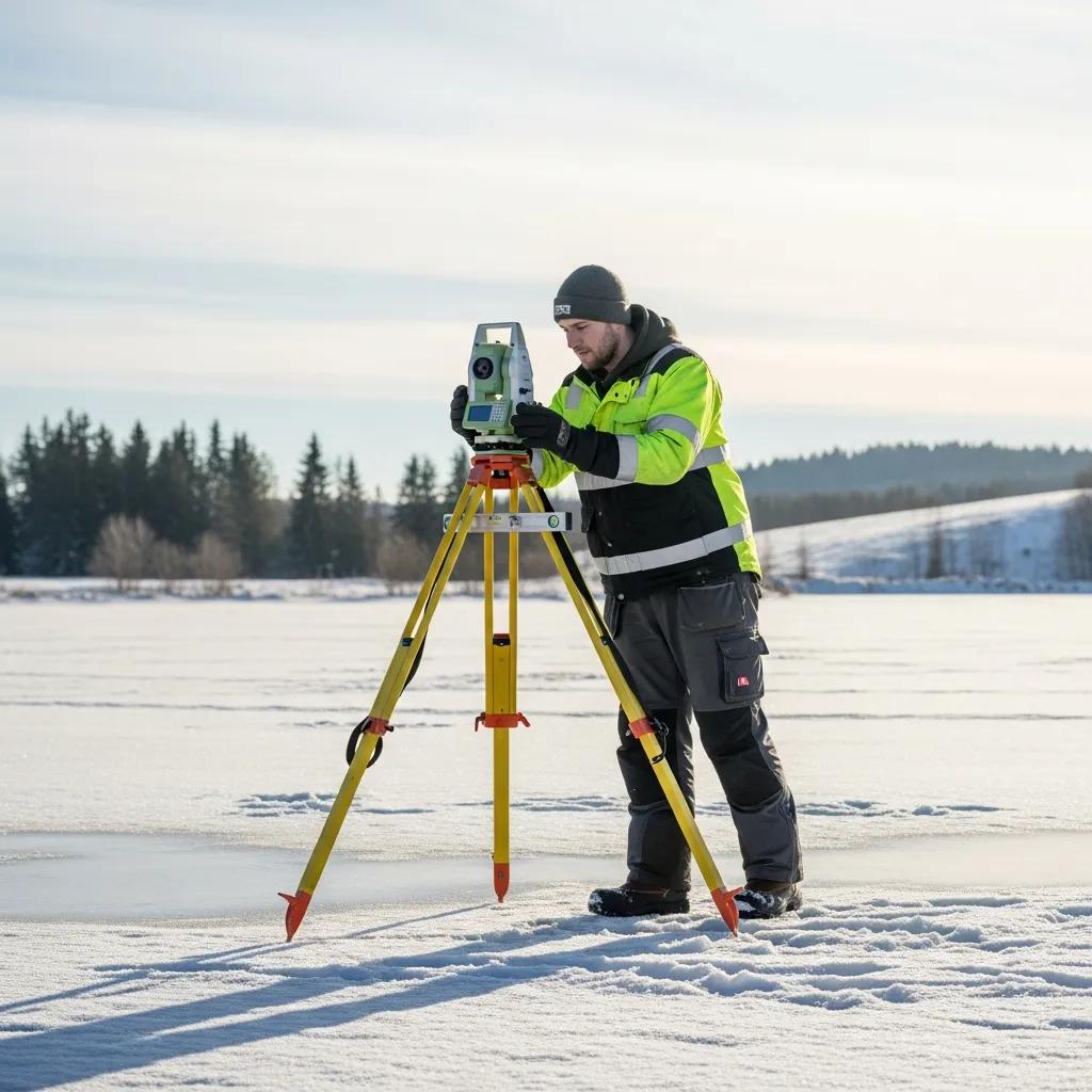
Frozen ground conditions in February can provide a stable base for surveying equipment, which is crucial for accurate measurements in colder climates. When the ground is frozen, there is a reduced risk of ground movement that can occur in warmer months due to thawing and shifting soil. This stability allows surveyors to set up their equipment with confidence, ensuring that measurements taken are reliable and consistent. However, this benefit depends on local climate conditions, as in some regions the ground may not be sufficiently frozen. Case studies have shown that surveys conducted on frozen ground can yield higher accuracy rates compared to those performed in softer, thawed conditions.
Further emphasizing the importance of stable ground, research highlights how frozen conditions contribute to the structural integrity required for precise surveying.
Benefits of Frozen Ground for Land Survey Stability
Frozen ground is soil or rock with a temperature below 0°C. The definition is based entirely on temperature and is independent of the water and ice content of the soil or rock. The large increase in soil strength on freezing has been utilized by engineers in the construction of frozen earth structures. The ice becomes a bonding agent, fusing together adjacent soil particles or blocks of rock to increase their combined strength and make them impervious to water seepage. Excavation and other work can proceed safely inside, or next to, a barrier of strong, watertight frozen earth. In cold regions, perennially frozen ground (or permafrost) remains at a temperature below 0°C continuously from year to year. Moisture in the form of water and ground ice may or may not be present. Seasonally frozen ground involves temperatures below 0°C only during the winter season.
Frozen Ground, 1994
How Does Winter Weather Affect Land Survey Costs and Efficiency?
Winter weather can have a significant impact on the costs and efficiency of land surveys. Understanding these factors can help property owners make informed decisions about scheduling their surveys.
What Cost Savings Can Property Owners Expect from Winter Land Surveys?
Property owners can expect potential cost savings when scheduling land surveys in winter in some markets. With lower demand for surveying services during the colder months, some surveyors may offer reduced rates. This can lead to savings, especially for larger projects. Additionally, some surveyors may provide discounts for off-season work, making February an economically advantageous time to schedule a survey in certain areas.
How Does Surveyor Availability in February Impact Scheduling and Turnaround?
Surveyor availability tends to be higher in February due to the seasonal slowdown in construction and real estate activities in many regions. This increased availability can lead to faster project turnaround times, allowing property owners to complete their surveys more quickly. Clients can benefit from flexible scheduling options, which can accommodate their specific needs and timelines. This flexibility is particularly valuable for those looking to expedite their land development or construction projects.
Which Types of Land Surveys Are Ideal for February and Winter Months?
Certain types of land surveys are particularly well-suited for February and the winter months. Understanding which surveys are ideal can help property owners make the best choices for their needs.
What Makes Boundary and ALTA Surveys Suitable for Winter Conditions?
Boundary surveys and ALTA surveys are often effective during winter months. The clarity provided by reduced foliage allows surveyors to accurately determine property lines and boundaries. Additionally, ALTA surveys, which require detailed information about property features, benefit from the visibility that winter conditions provide. Successful winter boundary surveys have demonstrated that the accuracy of these surveys can be enhanced when conducted in February, especially in areas with deciduous vegetation.
How Do Topographic Surveys Benefit from February’s Seasonal Advantages?
Topographic surveys also benefit from the seasonal advantages of February. With less vegetation, surveyors can obtain clearer readings of the land’s contours and features. This visibility allows for more accurate mapping of elevations and depressions, which is essential for planning construction projects. Case studies of topographic surveys conducted in winter have shown that the data collected can be more reliable, leading to better project outcomes in appropriate climates.
What Challenges Does Winter Present for Land Surveying and How Are They Overcome?
While winter conditions offer many advantages for land surveying, they also present specific challenges that must be addressed to ensure successful outcomes.
How Does Ludlow Engineers Mitigate Snow and Cold Weather Challenges?
Ludlow Engineers employs several strategies to mitigate the challenges posed by snow and cold weather. The use of specialized equipment designed for winter conditions allows surveyors to operate effectively even in adverse weather. Additionally, the team is trained to handle the unique challenges of winter surveying, ensuring that they can maintain accuracy and efficiency despite the elements.
What Techniques Ensure Survey Accuracy Despite Winter Conditions?
To ensure survey accuracy during winter, surveyors utilize various techniques. Adjustments to equipment settings are made to account for temperature variations, and careful planning is conducted to anticipate weather conditions. These techniques help maintain the integrity of the survey data, allowing for reliable results even in challenging winter environments.
How Should Property Owners Prepare for a February Land Survey?
Proper preparation is essential for property owners scheduling a land survey in February. Understanding the necessary steps can help ensure a smooth process.
What Are the Essential Steps in a February Land Survey Checklist?
Property owners should follow a checklist to prepare for their February land survey. Key steps include gathering necessary documents, such as property deeds and previous survey reports, and ensuring clear access to the property for surveyors. Additionally, it is important to communicate any specific concerns or requirements to the surveying team ahead of time.
How Can Clients Expedite Scheduling and Ensure Efficient Survey Completion?
To expedite scheduling and ensure efficient survey completion, clients should contactsurveyors early and be flexible with their scheduling options. Early communication allows surveyors to allocate resources effectively and accommodate client needs. Being proactive in the scheduling process can lead to quicker turnaround times and a more efficient surveying experience.
Where and How Can You Schedule Your February Land Survey with Ludlow Engineers?
Scheduling a land survey with Ludlow Engineers is straightforward and convenient. Understanding the available options can help clients get started.
What Contact Options Are Available for Booking a Winter Land Survey?
Clients can easily schedule their winter land survey by reaching out to Ludlow Engineers through various contact methods. They can call the office directly or send an email to discuss their specific needs and set up an appointment. Additionally, online scheduling options may be available for added convenience.
Why Choose Ludlow Engineers for Your February Land Survey Needs?
Choosing Ludlow Engineers for your February land survey needs comes with several advantages. With over 45 years of experience in land surveying and civil engineering, the firm is well-equipped to handle the unique challenges of winter surveying. Their commitment to client satisfaction and integrity ensures that property owners receive high-quality service tailored to their specific requirements.